
The Tavignano (French pronunciation: [taviɲano]; Corsican: Tavignanu) is a river on the island of Corsica, France. The Tavignano is 88.9 km (55.2 mi) long...
7 KB (789 words) - 00:06, 26 February 2022

around the Corsican coast starting from Cap Corse. Golo (near Bastia) Tavignano (in Aléria) Taravo (near Propriano) Cavu (near Zonza) Po/Pô (near Venice...
19 KB (1,623 words) - 12:14, 4 March 2024

Corsica. The fine barrier beaches are a recreational attraction. The Tavignano River (Tavignanu) enters the commune to the northwest and exits into the...
20 KB (2,559 words) - 09:06, 29 January 2024
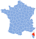
the department of Corse-du-Sud. Rivers include the Abatesco, Golo and Tavignano. The most populous commune is Bastia, the prefecture. As of 2019, there...
9 KB (449 words) - 17:35, 26 March 2024
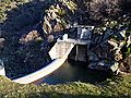
After the Roadblock, teams had to inflate a kayak and then paddle up the Tavignano River to the Pit Stop at the Cardiccia Dam. Episode 7: "Gently Down the...
74 KB (6,616 words) - 10:02, 2 April 2024

Altiani (section ZNIEFF Lower Valley of the Tavignano)
Rogna in Quà microregion consists of cliff villages in the valley of Tavignano. The village overlooks both the plain of Aleria and Corte as well as Venaco...
14 KB (1,629 words) - 13:50, 21 November 2022

Restonica (category Tributaries of the Tavignano)
department of Haute-Corse, Corsica, France. It is a tributary of the river Tavignano. The river has a steep and rocky course with many pools and waterfalls...
7 KB (651 words) - 14:53, 22 April 2024
Folelli-Orezza Moriani-Orezza Prunete-Cervione Alistro Bravone Tallone Pont-du-Tavignano Aleria Puzzichella Ghisonaccia Prunelli-Pietrapola Cavone, Corsica...
2 KB (182 words) - 02:05, 9 March 2024

Filosorma Forêt de l'Onca Forêt de l'Ospédale Forêt de Tartagine Forêt de Tavignano Forêt de Valdo-Niello Forêt de Vizzavona (14 km2) Forêt de Zonza Forêt...
10 KB (1,126 words) - 12:14, 20 March 2024
Niellu to the south. It is drained by the Fango river to the west, the Tavignano to the southeast, the Golo to the east, the Asco and Tartagine to the...
6 KB (304 words) - 02:14, 28 September 2022
21250°N 9.01194°E / 42.21250; 9.01194 Type glacial Primary outflows Tavignano Basin countries France Surface area 0.055 km2 (0.021 sq mi) Average depth...
2 KB (48 words) - 14:04, 24 January 2023

Jubainville's list of those toponyms in Corsica include, north of the Tavignano River: Venzolasca, Grillasca village in Olmeto, Feciasco and Prucinasca...
27 KB (3,417 words) - 14:52, 5 May 2024

turn a tributary of the Restonica river. It is in the watershed of the Tavignano river. Géoportail - IGN, Géoportail, retrieved 12 November 2011 Sandre...
2 KB (91 words) - 21:41, 17 January 2022

Vecchio (river) (category Tributaries of the Tavignano)
department of Haute-Corse, Corsica, France. It is a tributary of the river Tavignano. The Vecchio is 24.27 kilometres (15.08 mi) long. It crosses the communes...
7 KB (697 words) - 13:54, 19 January 2022

part of the Rogna in La micro-region located on the right bank of the Tavignano extending from Vivario to the plain. Access to the commune is by the minor...
7 KB (496 words) - 09:08, 18 January 2024

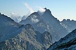
from the Monte Rotondo and Monte Renoso massifs by the valley of the Tavignano river. To the northwest it is separated from the Monte Cinto and Monte...
3 KB (192 words) - 17:11, 14 April 2024

(south) bank. There is a legend that three brothers, Liamone, Golo and Tavignano, suffered from the cold in the mountains of the central chain of Corsica...
8 KB (929 words) - 16:38, 12 March 2024

architectural heritage. There is a legend that three brothers, Liamone, Golo and Tavignano, suffered from the cold in the mountains of the central chain of Corsica...
9 KB (1,034 words) - 04:30, 30 September 2022

Tagnone (category Tributaries of the Tavignano)
department of Haute-Corse, Corsica, France. It is a tributary of the river Tavignano. The Tagnone is 35.14 kilometres (21.83 mi) long. It crosses the communes...
6 KB (605 words) - 13:28, 19 January 2022
and the Étang de Diane. At the north the wetland is delimited by the Tavignano river. The wetland is 3.6 kilometres (2.2 mi) long and covers an area...
8 KB (689 words) - 13:08, 12 April 2024

the north, with the Centre Corse (Centru di Corsica) to the south, the Tavignano valley and the east coast of the island, and (beyond the Col de Vizzavona)...
6 KB (644 words) - 06:06, 13 November 2023

Corsiglièse (category Tributaries of the Tavignano)
department of Haute-Corse, Corsica, France. It is a tributary of the river Tavignano. The Corsiglièse is 24.31 kilometres (15.11 mi) long. The stream rises...
4 KB (226 words) - 13:58, 19 January 2022

It is the highest point on the ridge line that separates the Golo and Tavignano valleys. Punta Artica is 2,327 metres (7,635 ft) high. It has a clean...
6 KB (343 words) - 14:52, 8 September 2023

between the communes of Aléria in the south and Tallone in the north. The Tavignano river enters the sea just south of Aléria and the lagoon. The Étang de...
12 KB (1,287 words) - 21:34, 17 January 2022
of Arbitration. This was the first international commission since the Tavignano inquiry in 1922. Proceedings were divided into a written and an oral stage...
5 KB (542 words) - 08:16, 13 May 2024

by the Golo valley to the north, the Tyrrhenian Sea to the east, the Tavignano valley to the south, and the central valley of Corse from Corte to Ponte...
7 KB (502 words) - 15:04, 19 February 2024

to Casevecchie. The commune is watered by the Tagnone, a tributary of Tavignano that separates an area of hills to the north from the plain, which is...
6 KB (449 words) - 09:07, 18 January 2024

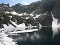
elevation of 1743 m, its surface area is 0.065 km². The lake is on the Tavignano river near to its source below the 1,883 metres (6,178 ft) Bocca a Reta...
2 KB (84 words) - 21:41, 17 January 2022

Casaluna Erco Fium'Alto Buccatoggio Alesani Alistro Chiosura Bravone Tavignano (88.9 km (55.2 mi)) Corsiglièse Restonica Tagnone Vecchio Fiumorbo (45...
5 KB (506 words) - 00:29, 13 December 2022
Sovenzia, Corscia and Castirla hydroelectric plants. The Sega dam on the Tavignano at an altitude of 1,084 metres (3,556 ft) feeds a conduit that carries...
6 KB (558 words) - 23:57, 30 September 2022