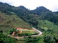
 | The Tenasserim Hills or Tenasserim Range (Burmese: တနင်္သာရီ တောင်တန်း, [tənɪ̀ɰ̃θàjì tàʊɰ̃dáɰ̃]; Thai: ทิวเขาตะนาวศรี, RTGS: Thio Khao Tanao Si, pronounced... 23 KB (2,383 words) - 10:27, 3 April 2024 |
Tanintharyi Region in Myanmar (Burma) Tenasserim town, a former name of Tanintharyi Tenasserim Hills or Tenasserim Range, part of the Indo-Malayan mountain... 661 bytes (124 words) - 19:45, 21 November 2023 |
 | Malay Peninsula (redirect from Tenasserim Peninsula) an Austronesian people. The Titiwangsa Mountains are part of the Tenasserim Hills system and form the backbone of the peninsula and the southernmost... 20 KB (1,380 words) - 02:24, 26 March 2024 |
 | Tanintharyi Region (redirect from Tenasserim Division, Burma) to the Kra Isthmus. It borders the Andaman Sea to the west and the Tenasserim Hills, beyond which lie Thailand, to the east. To the north is the Mon State... 24 KB (1,906 words) - 16:27, 23 April 2024 |
 | Fea's muntjac (redirect from Tenasserim muntjac) named after zoologist Leonardo Fea. Its other name comes from the Tenasserim Hills, between Burma and Thailand. Timmins, R.; Steinmetz, R.; Chutipong... 2 KB (151 words) - 00:26, 23 September 2022 |
 | includes lowland forests along the coasts, and montane forests on the Tenasserim Hills and Bilauktaung range, which form the mountainous spine of the isthmus... 5 KB (478 words) - 13:39, 21 January 2024 |
the Tenasserim Hills, extending further northwards for over 400 km (250 mi) beyond the Three Pagodas Pass. The Kra Isthmus is in the Tenasserim-South... 5 KB (444 words) - 10:02, 14 April 2024 |
 | port. There area seven national parks in the mountainous areas of the Tenasserim Hills, along with two other national parks, make up region 3 (Ban Pong) of... 26 KB (2,065 words) - 16:37, 12 April 2024 |
 | Pinus latteri (redirect from Tenasserim Pine) Pinus latteri, or Tenasserim pine, is a pine native to Mainland Southeast Asia. Pinus latteri is a medium-sized to large tree, reaching 25–45 metres (82–148... 4 KB (383 words) - 18:45, 7 April 2024 |
 | and Thailand. It is named after the Tenasserim Hills. Phylogenetic evidence indicates that the Tenasserim lutung is an ancestor of the far more widespread... 2 KB (124 words) - 18:22, 3 December 2023 |
 | Khao Sok National Park (category Tenasserim Hills) Khao Sok National Park (Thai: เขาสก, pronounced [kʰǎw sòk]) is in Surat Thani Province, Thailand. Its area is 461,712 rai ~ 739 square kilometres (285 sq mi)... 13 KB (1,381 words) - 17:20, 12 April 2024 |
 | kilometres (50 mi) west of Bangkok and borders Myanmar to the west with the Tenasserim Hills as a natural border. The Mae Klong flows through the centre of Ratchaburi... 20 KB (1,561 words) - 16:44, 23 April 2024 |
 | Dawna Range (redirect from Dawna Hills) northern end of the Tenasserim Hills further south and southeast. The Dawna Range extends east of the Salween southwards from the Shan Hills for about 350 km... 9 KB (764 words) - 17:10, 18 March 2024 |
 | overran relatively thin Siamese defenses in the coast, crossed the Tenasserim Hills to the shore of the Gulf of Siam, and turned north towards Ayutthaya... 127 KB (17,165 words) - 15:15, 26 April 2024 |
 | ranges belong to the Titiwangsa Mountains, a southern subrange of the Tenasserim Hills that spans throughout southern Myanmar, southern Thailand and Peninsular... 69 KB (6,060 words) - 09:00, 19 April 2024 |
 | and an equatorial climate. Situated at the southern foothills of the Tenasserim Hills, inselbergs and massifs dominate the state's flat landscape, with Mount... 215 KB (19,249 words) - 12:04, 29 April 2024 |
Thanon Range, the latter a southern prolongation of the Shan Hills, as well as the Tenasserim Hills in Western Thailand. These areas exhibit mountainous terrain... 15 KB (1,904 words) - 10:18, 17 March 2024 |
 | state's highlands are part of the Nakawan Range, a subrange of the Tenasserim Hills system that spans through southern Myanmar, Southern Thailand and Peninsular... 34 KB (2,967 words) - 15:04, 17 April 2024 |
 | mountain ranges belong to the Titiwangsa Mountains, which are part of the Tenasserim Hills that span throughout southern Myanmar, southern Thailand and Peninsular... 66 KB (6,093 words) - 07:44, 19 April 2024 |
 | following the Tenasserim Hills. This narrow region stretches from Bangkok's outer reaches to the border with Myanmar and from the Shan Hills in the north... 7 KB (388 words) - 14:56, 10 April 2024 |
 | Three Pagodas Pass (category Tenasserim Hills) Ong, Thai pronunciation: [dàːn tɕeːdiː sǎːm ʔoŋ]) is a pass in the Tenasserim Hills on the border between Thailand and Myanmar (Burma), at an elevation... 7 KB (632 words) - 19:39, 29 February 2024 |
 | 550 square kilometres (210 sq mi) park in western Thailand in the Tenasserim Hills of Kanchanaburi Province, Amphoe Si Sawat in tambon Tha Kradan. Founded... 6 KB (447 words) - 17:34, 20 April 2024 |
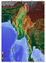 | 00 km2). Southeastern Hills Myanmar's Southeastern Hills and see the Tenasserim Plains have western shores backed by the Tenasserim Range respectively.... 46 KB (3,406 words) - 00:03, 14 April 2024 |
 | sa.wàt]), is a river in western Thailand. It has its source in the Tenasserim Hills and flows for about 380 kilometres (240 mi) through Sangkhla Buri,... 4 KB (427 words) - 05:56, 25 January 2024 |
 | mountain ranges belong to the Titiwangsa Mountains, which is part of the Tenasserim Hills that covers southern Myanmar, southern Thailand and Peninsular Malaysia... 125 KB (8,533 words) - 03:49, 12 April 2024 |
 | short-tailed python (P. kyaiktiyo; Zug, Gotte & Jacobs, 2011) VU West of the Tenasserim Hills, Myanmar † European python (Python europaeus; Szyndlar & Rage, 2003)... 19 KB (1,558 words) - 07:31, 27 March 2024 |
 | from northeast Thailand (Isan) by the Phetchabun mountain range. The Tenasserim Hills separate it from Myanmar to the west. In the north it is bounded by... 11 KB (703 words) - 18:25, 4 April 2024 |
 | Khao Sam Roi Yot National Park (category Tenasserim Hills) Thailand's largest freshwater marsh. The limestone hills are a sub-range of the Tenasserim Hills that arise at the shore of the Gulf of Thailand, with... 12 KB (1,273 words) - 04:55, 30 November 2023 |
 | Tenasserim Hills chain of mountains. Its namesake highest peak, Gunung Tahan, is the tallest mountain in Peninsular Malaysia and the whole Tenasserim... 794 bytes (67 words) - 09:44, 11 August 2023 |
 | Golden Mount or Phu Khao Thong( ภูเขาทอง) (Bangkok (Krungthep)) Sam Muk Hill Archived 2009-01-09 at the Wayback Machine Bangkok Post, "Thailand's highest... 52 KB (1,459 words) - 18:54, 18 April 2024 |