
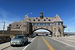
The Towers is a historic structure located at 35 Ocean Road in Narragansett, Rhode Island. It is the only remnant of the Narragansett Pier Casino built...
5 KB (481 words) - 17:18, 29 January 2024

Narragansett is a town in Washington County, Rhode Island, United States. The population was 14,532 at the 2020 census. However, during the summer months...
27 KB (2,432 words) - 13:02, 30 April 2024
Narragansett Pier is an unincorporated village and a census-designated place (CDP) in the town of Narragansett in Washington County, Rhode Island, United...
8 KB (553 words) - 00:35, 16 May 2024

Dutch Island is an island lying west of Conanicut Island at an entrance to Narragansett Bay in Rhode Island, United States. It is part of the town of...
13 KB (1,392 words) - 19:17, 15 November 2023

largest island in Narragansett Bay. It also includes the uninhabited Dutch Island and Gould Island. According to the United States Census Bureau, the town...
23 KB (2,208 words) - 13:01, 30 April 2024

1659 call the island "Red Island" (Roodt Eylandt). The first English settlement in Rhode Island was the town of Providence, which the Narragansett granted...
176 KB (15,405 words) - 10:33, 16 May 2024
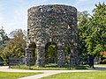
The Newport Tower, also known as the Old Stone Mill, is a round stone tower located in Touro Park in Newport, Rhode Island, the remains of a windmill...
24 KB (2,945 words) - 12:21, 9 April 2024

The Towers Historic District is a historic district in Narragansett, Rhode Island, encompassing a city block bounded by the Atlantic Ocean, Exchange Place...
2 KB (182 words) - 22:28, 9 August 2023

was burned to the ground by the Narragansetts during King Philip's War. Later in the year, the Rhode Island legislature formally rebuked the other colonies...
121 KB (10,502 words) - 17:35, 5 May 2024

the same pillars. The structure is named after Hannah Robinson (1746–1773), a colonial Rhode Island resident and daughter of a wealthy Narragansett society...
7 KB (954 words) - 04:23, 31 October 2023

a village in the town of South Kingstown, Rhode Island, United States, and the commercial center of South Kingstown. Together with the village of Peace...
9 KB (850 words) - 02:30, 17 May 2024

Narragansett Park was an American horse and motor racing venue in Cranston, Rhode Island. Narragansett Park opened on July 31, 1867. The one-mile track...
10 KB (1,113 words) - 15:45, 19 March 2023

long numbered state highway located in Washington County, Rhode Island, United States. The route, which parallels U.S. Route 1 (US 1) for its entire length...
16 KB (1,453 words) - 01:02, 6 March 2023

Newport is a seaside city on Aquidneck Island in Rhode Island, United States. It is located in Narragansett Bay, approximately 33 miles (53 km) southeast...
77 KB (7,012 words) - 22:29, 29 March 2024
Towers (Atlantic Highlands, New Jersey), on the National Register of Historic Places (NRHP) The Towers (Narragansett, Rhode Island), on the NRHP The Towers...
999 bytes (146 words) - 09:06, 24 January 2022

Dunmere is a historic estate at 560 Ocean Road in Narragansett, Rhode Island. The estate, which originally included a 3+1⁄2-story Queen Anne/Stick style...
9 KB (1,272 words) - 05:13, 6 August 2023

County, Rhode Island. The route begins at an intersection with Ocean Road in the village of Narragansett Pier (within the town of Narragansett), just north...
8 KB (808 words) - 01:13, 6 March 2023
PPL Corporation (redirect from Rhode Island Energy)
2021. The sale of the Narragansett Electric Company was completed on May 25, 2022, and Narragansett Electric was renamed Rhode Island Energy. In November...
11 KB (1,074 words) - 14:11, 17 April 2024

is a United States Army Reserve installation in the Point Judith area of Narragansett, Rhode Island. During World War II this was a coastal defense fort...
7 KB (745 words) - 19:26, 15 November 2023

Rhode Island, United States. The population was 16,359 at the 2020 census. Tiverton is located on the eastern shore of Narragansett Bay, across the Sakonnet...
27 KB (2,288 words) - 13:03, 30 April 2024

Quonset Point (redirect from Quonset Point, Rhode Island)
Quonset, is a small peninsula in Narragansett Bay in the town of North Kingstown, Rhode Island. Its name is widely known from the Quonset hut, which was first...
9 KB (1,186 words) - 05:05, 7 February 2024

Sachems of the Narragansett Tribe, Canonicus and Miantonomoh, establishing the boundaries between the Narragansett Tribe and the Colony of Rhode Island, as well...
27 KB (2,219 words) - 13:03, 30 April 2024

Block Island is an island of the Outer Lands coastal archipelago, located approximately 9 miles (14 km) south of mainland Rhode Island and 14 miles (23 km)...
47 KB (4,962 words) - 00:07, 3 May 2024

that spans the East Passage of the Narragansett Bay in Rhode Island (northeastern United States). The bridge, part of RI 138, connects the city of Newport...
19 KB (1,912 words) - 23:46, 23 January 2024

Earlscourt Historic District (category Narragansett, Rhode Island)
Earlscourt Historic District is a residential historic district in Narragansett, Rhode Island, United States. It is centered on a stretch of Earles Court, between...
3 KB (199 words) - 05:15, 6 August 2023

Beach is a public recreation area fronting the Atlantic Ocean in the town of Narragansett, Rhode Island. The state park occupies 60 acres (24 ha) comprising...
3 KB (192 words) - 01:35, 3 August 2023

County, Rhode Island, bounded on the south by the Atlantic Ocean, on the west by the Sakonnet River, on the north by the town of Tiverton, and on the east...
37 KB (3,792 words) - 08:01, 8 May 2024
Ocean Road Historic District (category Narragansett, Rhode Island)
early 20th centuries in Narragansett, Rhode Island. The area is located south of The Towers, the center of the Narragansett Pier area, extending along...
3 KB (194 words) - 01:43, 8 August 2023

It coordinated the coast defenses of Narragansett Bay and Rhode Island from 1895 to 1950, beginning with the Endicott program. These included both coast...
48 KB (6,217 words) - 20:24, 11 February 2024
place in the town of Westerly, Rhode Island. The population was 154 at the 2010 census. It sits at the most-southwestern point in Rhode Island. It came...
20 KB (2,288 words) - 02:37, 17 May 2024