 | covers the western part of the Ruhr Area, as well as the Niederrheinische Tiefebene, the lower Rhine area. It is the most populated of all German administrative... 4 KB (237 words) - 13:53, 13 March 2024 |
 | (German: Norddeutsches Tiefland – North German Plain; Mitteleuropäische Tiefebene; Polish: Nizina Środkowoeuropejska – Central European Plain; Danish: Nordeuropæiske... 4 KB (455 words) - 15:30, 28 March 2024 |
Upper Rhine Plain (redirect from Oberrheinische Tiefebene) Plain, Rhine Rift Valley or Upper Rhine Graben (German: Oberrheinische Tiefebene, Oberrheinisches Tiefland or Oberrheingraben, French: Vallée du Rhin)... 10 KB (1,059 words) - 22:28, 16 November 2023 |
 | North German Plain (redirect from North German Tiefebene) The North German Plain or Northern Lowland (German: Norddeutsches Tiefland) is one of the major geographical regions of Germany. It is the German part... 11 KB (1,399 words) - 17:58, 5 January 2022 |
 | (Hungarian: Kisalföld, Slovak: Malá dunajská kotlina, German: Kleine Ungarische Tiefebene) is a plain (tectonic basin) of approximately 8,000 km² in northwestern... 4 KB (382 words) - 07:47, 30 March 2024 |
 | Silesian Lowlands (redirect from Schlesische Tiefebene) Silesian Lowlands (or Silesian Plains, Polish: Nizina Śląska, Czech: Slezská nížina, German: Schlesische Niederung) are lowlands located in Silesia, Poland... 2 KB (137 words) - 23:35, 8 March 2024 |
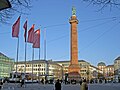 | Darmstadt is located in the Upper Rhine Plain (German: Oberrheinische Tiefebene), a major rift, about 350 km (217 mi) long and on average 50 km (31 mi)... 68 KB (5,935 words) - 05:59, 5 April 2024 |
 | cities of Wiesloch and Walldorf at the border of the Oberrheinischen Tiefebene. The town is located at the foot of the Letzenberg, a hill of 244 m height... 2 KB (134 words) - 18:39, 10 April 2023 |
 | years ago the Neckar flowed through a pastureland in the Oberrheinische Tiefebene in a tangle of meanders, slings,[clarification needed] old waters[clarification... 82 KB (9,579 words) - 09:13, 29 December 2023 |
 | Humboldt's Kosmos"). Geognostische Untersuchungen in der norddeutschen Tiefebene (Geognostic investigations in the North German Plain); magazine, (1845)... 2 KB (153 words) - 13:36, 15 December 2023 |
(Böhmerwald) Boven-Rijnse Laagvlakte Upper Rhine Plain (Oberrheinische Tiefebene) Breylen, Brijlen Brilon Brunswijk Brunswick (Braunschweig) historic Dusseldorp... 6 KB (45 words) - 16:52, 21 March 2022 |
 | Neuere Ergebnisse in der topographischen Untersuchung der Erdwalle in der Tiefebene, Móra Ferenc Múzeum Évkönyve, Szeged, 1969/2 Penguin Atlas of the Roman... 4 KB (512 words) - 07:01, 4 April 2022 |
 | (1931): Beiträge zur Ökologie der Sandvegetation der Oberrheinischen Tiefebene. Zeitschr. f. Botanik 24: 81–185, Jena. Wikimedia Commons has media related... 11 KB (1,277 words) - 12:24, 28 November 2023 |
 | Hans Joachim Franzke, Rainer Müller: Die geologische Entwicklung der Tiefebene und der Mittelgebirge in Niedersachsen.[dead link] (pdf) In: Veröffentlichungen... 9 KB (963 words) - 22:38, 2 April 2024 |
Hainleite descends relatively gently into the Erfurt Lowland (Erfurter Tiefebene, part of the Thuringian Basin). The vegetation on the Hainleite is characterised... 4 KB (562 words) - 19:58, 19 April 2022 |
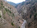 | basin into the Freiburg area of the Upper Rhine Plain (Oberrheinische Tiefebene). Hirschsprung gorge with a deer monument (Hirschsprung saga) St. Oswald... 8 KB (1,085 words) - 01:50, 3 August 2021 |
 | Freiburg. Denzlingen is located in the Upper Rhine Valley (Oberrheinische Tiefebene) at the edge of the Black Forest (Schwarzwald) between the river Elz in... 9 KB (783 words) - 19:03, 11 September 2021 |
 | Forest (Pfälzerwald) and thus leaves the Upper Rhine Plain (Oberrheinische Tiefebene). Within the Palatine Forest, the number of curves along the line increases... 137 KB (15,784 words) - 01:31, 28 March 2024 |
 | edge of the northern part of the Upper-Rhine Valley (Oberrheinischen Tiefebene) on the left side of the Rhine, about 30 kilometres (19 mi) from it. It... 27 KB (4,251 words) - 18:09, 24 September 2023 |