 | Trail Ridge Road is the name for the 48-mile (77 km) stretch of U.S. Highway 34 that traverses Rocky Mountain National Park from Estes Park, Colorado in... 12 KB (994 words) - 02:09, 11 October 2023 |
 | The Civilian Conservation Corps built the main automobile route, Trail Ridge Road, in the 1930s. In 1976, UNESCO designated the park as one of the first... 99 KB (10,390 words) - 18:33, 9 May 2024 |
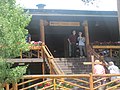
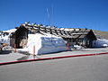 | Alpine Visitor Center (redirect from Trail Ridge, Colorado) sea level at Fall River Pass, one mile west of the highest point on Trail Ridge Road and four miles east of the Continental Divide at Milner Pass in the... 2 KB (272 words) - 21:23, 12 April 2024 |
National Park began when Paleo-Indians traveled along what is now Trail Ridge Road to hunt and forage for food. Ute and Arapaho people subsequently hunted... 37 KB (4,540 words) - 02:28, 2 May 2024 |
 | The Blue Ridge Parkway is a National Parkway and All-American Road in the United States, noted for its scenic beauty. The parkway, which is the longest... 65 KB (4,790 words) - 17:34, 5 May 2024 |
A ridge road is a road or track, usually ancient, that runs along the ridge formed by a line of hills. Ridge Road may refer to: Canada Ridge Road, formerly... 863 bytes (166 words) - 11:35, 5 December 2023 |
 | U.S. Highway 34 on Trail Ridge Road between Granby and Estes Park. However, as at Milner Pass on the Continental Divide, the road does not descend after... 6 KB (277 words) - 18:15, 9 November 2023 |
 | Flat where the original Truckee Trail diverged from modern roads to descend into a steep canyon and use the Bear River ridge to get around impassable terrain... 214 KB (31,614 words) - 23:32, 2 May 2024 |
 | Rollins Pass (redirect from Old Ute Trail) December 31, 1998. "Twice Threading the Eye of the Needle: Rollins Pass, Trail Ridge Road". June 1, 2012. "Arapaho & Roosevelt National Forests Pawnee National... 214 KB (19,010 words) - 05:04, 10 February 2024 |
 | improved road in the state (the highest is Trail Ridge Road, US HWY 34 at 12,183 ft). It is the fourth-highest paved road in the state after Mount Evans Scenic... 5 KB (560 words) - 07:09, 26 September 2022 |
 | northern end. A panoramic view of the range is available from sections of Trail Ridge Road in Rocky Mountain National Park. One of the northernmost peaks, Nokhu... 11 KB (1,133 words) - 08:59, 19 March 2024 |
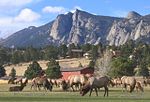 | through the town on their migrations to and from the national park. Trail Ridge Road, the highest continuous highway in the United States, runs from Estes... 39 KB (3,529 words) - 17:41, 28 April 2024 |
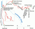
The Trail Ridge Road/Beaver Meadow National Scenic Byway is a 55-mile (89 km) All-American Road and Colorado Scenic and Historic Byway located in Rocky... 4 KB (262 words) - 16:22, 23 December 2023 |
 | largely within Rocky Mountain National Park, extending north from Trail Ridge Road approximately 15 mi (24 km). The Arapaho name is "nooku-bee3ei-no,"... 3 KB (230 words) - 23:45, 7 April 2023 |
 | the trail is 8,500 feet (2,600 m) to 9,000 feet (2,700 m) in elevation. Much of the CDT follows high, grassy ridges with some walking on dirt roads required... 40 KB (4,723 words) - 18:34, 25 March 2024 |
 | Mondays-; Us, 8:00 a m-12:00 p m Saturdays- Sundays in winter Recorded Trail Ridge Road status:586-1222 Contact. "Hiking Essentials - Rocky Mountain National... 23 KB (2,589 words) - 03:30, 8 April 2024 |
 | 1920 to serve tourists visiting Rocky Mountain National Park via the Trail Ridge Road, completed the same year. Located in Grand Lake, Colorado, the rustic... 3 KB (219 words) - 22:22, 6 August 2023 |
 | via Newspapers.com. Ridge, Alice A. & Ridge, John William (2000). Introducing the Yellowstone Trail: A Good Road from Plymouth Rock to Puget Sound, 1912–1930... 9 KB (955 words) - 06:57, 14 December 2023 |
 | 34, also known as Trail Ridge Road between Estes Park and Grand Lake. The pass is not, however, the high point on Trail Ridge Road, which crests at 12... 6 KB (320 words) - 00:12, 4 November 2023 |
 | U.S. Route 34 (category Ronald Reagan Trail) of Chicago. Through Rocky Mountain National Park it is known as the Trail Ridge Road where it reaches elevation 12,183 feet (3,713 m), making one of the... 14 KB (1,249 words) - 18:06, 11 April 2024 |
 | "Address Restricted". Coordinates are those of the Grand Lake end of the trail as provided by its GNIS record; the NRIS gives neither coordinates or a... 15 KB (489 words) - 21:47, 29 January 2024 |
| U.S. Route 34 in Colorado (category Infobox road instances in Colorado) United States (Map). National Geographic. October 2006. "Destinations: Trail Ridge Road, Colorado". Retrieved March 30, 2010. "Interchange Information for... 11 KB (395 words) - 13:44, 7 March 2024 |
 | Grand Lake is located in northeastern Grand County. U.S. Route 34 (Trail Ridge Road) runs through the western side of the town, entering Rocky Mountain... 24 KB (1,557 words) - 16:08, 7 May 2024 |
 | northeast into Rocky Mountain National Park, crossing the mountains as Trail Ridge Road and reaching Estes Park 60 miles (97 km) northeast of Granby. At the... 17 KB (1,375 words) - 18:32, 6 May 2024 |
 | National Historic Trail through Sedgwick County Santa Fe National Historic Trail through southeastern Colorado The National Scenic Trail that passes through... 32 KB (2,586 words) - 18:50, 8 February 2024 |
 | several miles northeast of the pass. Trail Ridge Road is the highest paved through highway in North America. Trail Ridge Road is normally closed from about October... 53 KB (719 words) - 15:07, 5 April 2024 |
Peak to Peak Scenic Byway (category Infobox road temporary tracking category 1) National Historic Landmark. The Peak to Peak Highway connects to the Trail Ridge Road/Beaver Meadow National Scenic Byway at Estes Park. Rocky Mountain National... 4 KB (277 words) - 03:36, 10 May 2023 |
 | The Ridgeway (redirect from Ridgeway National Trail) described as Britain's oldest road. The section clearly identified as an ancient trackway extends from Wiltshire along the chalk ridge of the Berkshire Downs... 15 KB (1,330 words) - 19:44, 13 April 2024 |
 | main part of valley runs the lower section of the Trail Ridge Road - the highest continuous paved road in the United States. The construction of a water... 14 KB (1,359 words) - 01:54, 17 March 2024 |
Hurricane Ridge is a mountainous area in Washington's Olympic National Park. Approximately 18 miles (29 km) by road from Port Angeles, the ridge is open... 12 KB (1,158 words) - 23:12, 11 February 2024 |