Transportation in Phoenix, Arizona is primarily via private cars. Public transport is run under the brand Valley Metro, and consists of buses, light rail... 14 KB (1,289 words) - 02:29, 28 January 2024 |
Swift Transportation is a Phoenix, Arizona-based American truckload motor shipping carrier, part of Knight-Swift. With over 23,000 trucks, it is the largest... 11 KB (1,188 words) - 17:01, 18 April 2024 |
The metropolitan area of Phoenix in the U.S. state of Arizona contains one of the nation's largest and fastest-growing freeway systems, with over 1,405... 42 KB (4,354 words) - 15:48, 23 March 2024 |
 | Phoenix (/ˈfiːnɪks/ FEE-niks; Spanish: Fénix;) is the capital and most populous city of the U.S. state of Arizona, with 1,608,139 residents as of 2020... 204 KB (19,432 words) - 22:56, 10 May 2024 |
 | in Arizona, as in all U.S. states, is regulated by the United States Department of Transportation as well as by state and tribal law. All of Arizona is... 6 KB (558 words) - 02:59, 9 May 2024 |
 | Sun Belt, runs east from California, enters Arizona near the town of Ehrenberg and continues through Phoenix and Tucson and exits at the border with New... 61 KB (4,274 words) - 18:36, 19 March 2024 |
Arizona Department of Transportation (ADOT, /ˈeɪdɒt/) is an Arizona state government agency charged with facilitating mobility within the state. In addition... 8 KB (762 words) - 20:59, 5 March 2024 |
 | Phoenix Union Station is a former train station at 401 South 4th Avenue in downtown Phoenix, Arizona, United States. From 1971 to 1996 it was an Amtrak... 17 KB (1,687 words) - 20:47, 27 December 2023 |
Valley Metro (redirect from Valley metro phoenix) Public Transportation Authority, more popularly known as Valley Metro, is the unified public brand of the regional transit system for the Phoenix metropolitan... 32 KB (4,194 words) - 12:27, 7 May 2024 |
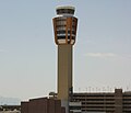 | downtown Phoenix, in Maricopa County, Arizona, United States. It is Arizona's largest and busiest airport; among the largest commercial airports in the United... 83 KB (4,820 words) - 00:52, 11 May 2024 |
 | freeways in metropolitan Phoenix Arizona Department of Transportation (2014). "Arizona Parkways, Historic and Scenic Roads" (PDF). Phoenix: Arizona Department... 40 KB (2,441 words) - 21:49, 3 March 2024 |
 | Arizona State Route 101 (SR 101) or Loop 101 is a semi-beltway looping around the Phoenix Metropolitan Area in central Arizona, United States. It connects... 25 KB (1,732 words) - 02:40, 6 February 2024 |
The transportation system of Arizona comprises car, rail, air, bus, and bicycle transport. Amtrak operates the Southwest Chief, Sunset Limited, and Texas... 10 KB (960 words) - 15:37, 9 May 2024 |
 | route is in Maricopa County. Arizona portal U.S. roads portal "2008 State Highway System Log" (PDF). Arizona Department of Transportation. December... 6 KB (727 words) - 17:33, 13 June 2023 |
 | Valley Metro Rail (redirect from Light rail in phoenix) 29.8-mile (48 km) light rail system serving the cities of Phoenix, Tempe, and Mesa in Arizona, USA. The network, which is part of the Valley Metro public... 62 KB (5,439 words) - 04:04, 21 April 2024 |
published monthly in Phoenix by a unit of the Arizona Department of Transportation (ADOT). The magazine began in July 1921 by the Arizona Highway Department... 9 KB (982 words) - 14:35, 31 March 2024 |
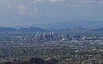 | statistical area in the Southwestern United States, with its largest principal city being the city of Phoenix. It includes much of central Arizona. The United... 42 KB (3,641 words) - 02:55, 9 May 2024 |
 | Interstate 17 (redirect from Interstate 17 in Arizona) entirely within the US state of Arizona. I-17's southern terminus lies in Phoenix, at I-10/US 60 and its northern terminus is in Flagstaff, at Milton Road north... 26 KB (1,442 words) - 03:47, 5 May 2024 |
 | Kate Gallego (category Mayors of Phoenix, Arizona) serving as the 62nd mayor of Phoenix, Arizona, since 2019. A member of the Democratic Party, she previously served on the Phoenix City Council from 2014 to... 15 KB (1,232 words) - 09:43, 28 April 2024 |
 | Arizona State Route 51 (SR 51), also known as the Piestewa Freeway, is a numbered state highway in Phoenix, Arizona. It connects Interstate 10 and Loop... 15 KB (1,203 words) - 05:49, 7 February 2024 |
 | Knight-Swift (redirect from Knight Transportation, Inc.) Knight-Swift Transportation Holdings Inc. (referred to as Knight-Swift) is a publicly traded, American motor carrier holding company based in Phoenix, Arizona. It... 10 KB (789 words) - 22:53, 3 April 2024 |
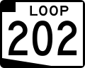 | Arizona State Route 202 (SR 202) or Loop 202 (202L) is a semi-beltway circling the eastern and southern areas of the Phoenix metropolitan area in central... 45 KB (3,333 words) - 03:07, 6 February 2024 |
 | The Stack (category Transportation buildings and structures in Phoenix, Arizona) four-level stack interchange in Phoenix, Arizona that facilitates movements between Interstate 17/U.S. Route 60 and Interstate 10. In 2006, the Stack interchange... 4 KB (269 words) - 23:25, 31 January 2024 |
 | of Phoenix, Arizona, goes back millennia, beginning with nomadic paleo-Indians who existed in the Americas in general, and the Salt River Valley in particular... 80 KB (9,580 words) - 18:43, 10 March 2024 |
 | southeastern suburbs of Phoenix to planned ones in northwestern Pinal County. It is the lowest-numbered state route in Arizona. The first mile from Loop... 18 KB (1,667 words) - 07:40, 25 March 2024 |
(Phoenix) Arizona Federal Credit Union (Phoenix) Arizona Public Service (Phoenix) Arizona Republic (Phoenix) Axon (Scottsdale) Banner Health (Phoenix)... 5 KB (422 words) - 23:06, 30 May 2022 |
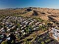 | village of Phoenix, Arizona. Ahwatukee forms the southernmost portion of Phoenix, and is considered part of the East Valley region of the Phoenix metropolitan... 23 KB (2,053 words) - 22:10, 15 April 2024 |
of the city of Phoenix, Arizona, United States. 1–300 – Hohokam establish several villages along the Gila River. 300 – Ceramics appear in the Hohokam culture... 72 KB (6,652 words) - 15:40, 9 May 2024 |
 | of Transportation. Archived from the original (PDF) on December 28, 2010. Retrieved April 9, 2008. "Arizona Scenic Roads Map" (PDF). Phoenix, Arizona: Arizona... 20 KB (1,696 words) - 21:00, 23 March 2024 |
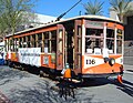 | The Phoenix Street Railway provided streetcar service in Phoenix, Arizona, United States, from 1888 to 1948. The motto was "Ride a Mile and Smile the... 8 KB (1,003 words) - 19:20, 23 April 2024 |