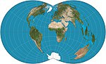
 | The transverse Mercator map projection (TM, TMP) is an adaptation of the standard Mercator projection. The transverse version is widely used in national... 37 KB (4,481 words) - 08:45, 7 November 2023 |
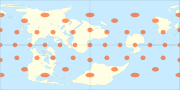
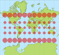
 | The Mercator projection (/mərˈkeɪtər/) is a conformal cylindrical map projection presented by Flemish geographer and cartographer Gerardus Mercator in... 42 KB (5,968 words) - 14:36, 13 March 2024 |
 | The Universal Transverse Mercator (UTM) is a map projection system for assigning coordinates to locations on the surface of the Earth. Like the traditional... 17 KB (2,610 words) - 23:05, 29 February 2024 |
 | constant. These are some conformal projections: Mercator: Rhumb lines are represented by straight segments Transverse Mercator Stereographic: Any circle of... 58 KB (6,482 words) - 15:55, 11 January 2024 |
 | Projected coordinate system (section Projections) map projection. Each projected coordinate system, such as "Universal Transverse Mercator WGS 84 Zone 26N," is defined by a choice of map projection (with... 21 KB (2,802 words) - 02:18, 12 April 2024 |
| Northern Ireland (OSNI) in 2001. The name is derived from the Transverse Mercator projection it uses and the fact that it is optimised for the island of... 7 KB (696 words) - 22:44, 13 August 2023 |
Transverse Mercator projection has many implementations. Louis Krüger in 1912 developed one of his two implementations that expressed as a power series... 25 KB (4,237 words) - 10:02, 3 September 2023 |
 | The oblique Mercator map projection is an adaptation of the standard Mercator projection. The oblique version is sometimes used in national mapping systems... 5 KB (555 words) - 17:31, 10 January 2023 |
Universal Transverse Mercator coordinate system. MTM uses a transverse Mercator projection with zones spaced 3° of longitude apart. The coordinate system... 471 bytes (50 words) - 13:52, 3 October 2019 |
drawn as a straight line on the map.) Transverse Mercator projection Gauss–Krüger coordinate system (This projection preserves lengths on the central meridian... 11 KB (1,207 words) - 14:35, 23 April 2024 |
 | coordinate system for Israel. The name is derived from the transverse Mercator projection it uses and the fact that it is optimized for Israel. ITM has... 5 KB (447 words) - 23:59, 6 January 2024 |
meridian, measured on the Transverse Mercator projection N = distance north of the equator, measured on the Transverse Mercator projection ε=2r−1(r−1)2=a2−b2(b2){\displaystyle... 9 KB (1,421 words) - 08:11, 1 July 2023 |
 | parallels (as red lines) on the commonly used Mercator projection and the Transverse Mercator projection. On the former the parallels are horizontal and... 47 KB (6,180 words) - 14:50, 26 April 2024 |
 | a superior alternative to the commonly used Mercator projection, on the basis that the Mercator projection greatly distorts the relative sizes of regions... 19 KB (2,104 words) - 01:50, 27 April 2024 |
based on either a transverse Mercator projection or a Lambert conformal conic projection. The choice between the two map projections is based on the shape... 7 KB (965 words) - 15:06, 26 February 2024 |
 | Nevertheless, the use of the Cassini projection has largely been superseded by the transverse Mercator projection, at least with central mapping agencies... 5 KB (771 words) - 00:39, 9 November 2023 |
 | Space-oblique Mercator projection is a map projection devised in the 1970s for preparing maps from Earth-survey satellite data. It is a generalization... 4 KB (682 words) - 08:57, 26 July 2023 |
 | systems having moved onto conformal projection systems, typically modeled on the transverse Mercator projection. The rectangular polyconic has one specifiable... 3 KB (380 words) - 14:59, 3 November 2023 |
 | Tissot's indicatrix (category Map projections) The transverse Mercator projection with Tissot's indicatrices The stereographic projection with Tissot's indicatrices The sinusoidal projection with... 19 KB (2,683 words) - 02:54, 15 April 2024 |
 | inspired by the Dymaxion map. The projection does not have some of the major distortions of the Mercator projection, like the expansion of countries in... 5 KB (509 words) - 16:53, 17 April 2024 |
 | similar to the Palestine Grid but used the transverse Mercator projection. The difference between the two projections was only a few metres. After the establishment... 5 KB (519 words) - 00:57, 6 April 2024 |
| and to be slightly less flattened). The British maps adopt a transverse Mercator projection with an origin (the "true" origin) at 49° N, 2° W (an offshore... 19 KB (2,130 words) - 10:22, 14 April 2024 |
 | Scale (map) (section Mercator projection) prompted the development of the transverse Mercator projections in which a meridian is treated 'like an equator' of the projection so that we obtain an accurate... 35 KB (5,382 words) - 16:07, 7 March 2024 |
 | country (projected to the Airy ellipsoid then flattened using the Transverse Mercator projection), or as the point farthest from the boundary of the country... 13 KB (1,218 words) - 15:39, 11 February 2024 |
 | instance of a stereographic projection of the Earth's surface. Its popularity in cartography increased after Rumold Mercator used its equatorial aspect... 6 KB (721 words) - 18:13, 10 January 2023 |
| State University provides the following parameters for the projection: Jordan Transverse Mercator Geographic Coordinate System: GCS_International_1924 Datum:... 2 KB (275 words) - 20:39, 18 January 2022 |
 | The Winkel tripel projection (Winkel III), a modified azimuthal map projection of the world, is one of three projections proposed by German cartographer... 6 KB (593 words) - 06:18, 22 November 2023 |
| example, "Universal Transverse Mercator WGS 84 Zone 16N") comprises a choice of Earth ellipsoid, horizontal datum, map projection (except in the geographic... 15 KB (1,546 words) - 22:10, 9 April 2024 |
 | Johann Heinrich Lambert (section Map projection) any of his projections but they are now known as: Lambert conformal conic Transverse Mercator Lambert azimuthal equal area Lagrange projection Lambert cylindrical... 21 KB (2,267 words) - 04:11, 1 April 2024 |
 | proposed by Émile Guyou in 1887, and a transverse aspect was proposed by Oscar Adams in 1925. The projection has seen use in digital photography for... 13 KB (1,486 words) - 05:28, 5 February 2024 |