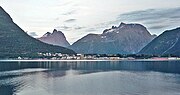
 | Trollryggen is a peak along the Trolltindene ridge along the Romsdalen valley. It is located in Rauma Municipality in Møre og Romsdal county, Norway.... 2 KB (164 words) - 22:51, 17 October 2023 |
winter, include: Trollryggen, Norway in winter 1972, Noshaq, Afghanistan in winter 1973, Trollryggen, Norway in winter 1974, Trollryggen, Norway in winter... 6 KB (643 words) - 22:38, 31 March 2024 |
 | below. From Trollstigrennet around 1952 (Stein Eriksen with ski pole). Trollryggen mountains, located between Romsdalen and Trollstigen. Acception Document... 16 KB (1,205 words) - 06:30, 27 September 2023 |
 | E136 highway lie 1 kilometre (0.62 mi) to the east in the valley. The Trollryggen peak is located about 700 metres (2,300 ft) to the south. The easiest... 2 KB (169 words) - 11:22, 15 November 2023 |
 | valley, including the mountains Store Trolltind, Store Venjetinden, Trollryggen, and Romsdalshornet. The Rauma Line railroad follows the river through... 3 KB (364 words) - 15:33, 11 June 2021 |
 | the valley) lies the mountain Store Trolltind—part of the Troll Wall/Trollryggen ridge. Romsdalshornet is a popular mountain for climbing, which is best... 3 KB (235 words) - 11:10, 1 July 2023 |
 | valley, including the mountains Store Trolltind, Store Venjetinden, Trollryggen, and Romsdalshornet. Romsdalen is joined by the Isterdalen valley with... 14 KB (1,560 words) - 23:00, 24 March 2024 |
 | 788 metres (5,866 ft), the highest point along the Troll Wall ridge Trollryggen at 1,740 metres (5,710 ft) Romsdalshorn at 1,550 metres (5,090 ft) Kyrkjetaket... 2 KB (120 words) - 23:58, 2 October 2022 |
 | time a groundbreaking achievement. Heen had several times attempted Trollryggen, a 2 kilometer long pillar at the edge of Trollveggen. One attempt was... 5 KB (572 words) - 13:36, 22 February 2024 |
Trollveggen or Troll Wall in Rauma, a vertical rock face, part of Trolltindane Trollryggen a summit and pillar in Trolltindane range Trolltindane (890 m), mountains... 870 bytes (135 words) - 21:55, 8 May 2020 |
 | in 1978), the Dolomites (north face of Cima Grande in 1975), Norway (Trollryggen in winter 1976), Caucasus (solo winter ascent of Donguz Orun 1983), Pamir... 4 KB (469 words) - 02:08, 18 September 2023 |
 | – Koshtan-Tau traverse (5145m) – Dykh-Tau (5198m), (Caucasus) 1976 – Trollryggen north face of the Trolls – 1st winter ascent via Rimon route – Norway... 7 KB (649 words) - 23:46, 28 August 2023 |
 | Trolltindane peaks stands opposite across the Rauma. The North Face of Trollryggen peak (1,740 m), Trollveggen (Troll Wall), is the tallest vertical cliff... 11 KB (1,332 words) - 00:34, 2 April 2024 |
 | of the municipality. The mountains Romsdalshornet, Store Trolltind, Trollryggen, Store Venjetinden, and the Troll Wall are all in the central part of... 24 KB (1,489 words) - 01:56, 17 January 2024 |
1969 Eiger, north face (Heckmair), Mont Maudit southeast arête 1971/72 Trollryggen, northeast face (Norway) 1974 Cengalo, northwest pillar 1976 Rotwand [de]... 4 KB (430 words) - 01:06, 11 January 2024 |
routes up to 7c+ in limestone part of Tatras Mountains of Norway 1973 – Trollryggen, N face (Troll Wall), Romsdal Valley, French route (French directissima)... 13 KB (1,635 words) - 16:06, 16 April 2023 |
 | is a noted mountaineer. In 1958, he was part of the first climbing of Trollryggen. He also climbed the mountain Tirich Mir in an expedition led by the... 5 KB (612 words) - 02:29, 27 September 2023 |
 | Sivorgfjella 74°51′S 11°22′W / 74.850°S 11.367°W / -74.850; -11.367 12192 Trollryggen 2670 Sør Rondane Mountains 72°40′48″S 27°00′00″E / 72.68000°S 27.00000°E... 119 KB (398 words) - 02:46, 11 July 2022 |