Tullah is a town in the northern part of the West Coast Range, on the west coast of Tasmania, about 111 km south of Burnie. The town has a population of...
7 KB (861 words) - 01:04, 23 October 2023

Wee Georgie Wood Railway (redirect from The Tullah Tramway)
tramway running from Tullah, on a 1.9 km (1.2 mi) short track by the edge of Lake Rosebery in the West Coast Municipality of Tasmania. The originally 10 km...
10 KB (1,004 words) - 03:14, 21 August 2023
containing the towns and settlements of Queenstown, Rosebery, Strahan, Tullah, and Zeehan. The Central councils contain three LGAs: Central Highlands...
25 KB (1,180 words) - 15:59, 7 May 2024
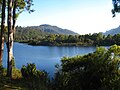
Lake Mackintosh (category Reservoirs in Tasmania)
development running north–south past Mount Farrell, adjacent to the town of Tullah in Tasmania. Fed by the damming of the Mackintosh, Sophia, Fury, Southwell, and...
5 KB (280 words) - 10:09, 10 March 2023

Zeehan (redirect from Zeehan, Tasmania)
Zeehan /ˈziːən/ is a town on the west coast of Tasmania, Australia 139 kilometres (86 mi) south-west of Burnie. It is part of the West Coast Council, along...
23 KB (2,310 words) - 02:14, 28 March 2024
Anthony Road (category Roads in Western Tasmania)
Road (Route B28) is a major B Route in Western Tasmania, running from the Murchison Highway (A10) at Tullah to the Zeehan Highway (A10) north of Queenstown...
3 KB (286 words) - 07:11, 5 July 2023
scheme" (PDF). Hydro Tasmania. February 2015. Archived from the original (PDF) on 6 July 2015. Retrieved 4 July 2015. "Tullah, Tasmania". Western Wilderness...
4 KB (251 words) - 21:23, 2 June 2023

Queenstown is a town in the West Coast region of the island of Tasmania, Australia. It is in a valley on the western slopes of Mount Owen on the West Coast...
17 KB (1,728 words) - 08:51, 31 March 2024

range and within the top thirty highest mountains in Tasmania. Lying close to the Williamsford and Tullah mining areas, the mountain is often found referred...
7 KB (725 words) - 21:28, 9 August 2022
The history of Tasmania begins at the end of the Last Glacial Period (approximately 12,000 years ago) when it is believed that the island was joined to...
67 KB (8,489 words) - 17:01, 12 May 2024

is a list of all bounded localities in Tasmania, Australia, as recognised by the Land Information System Tasmania. The definition of a locality for this...
130 KB (178 words) - 18:10, 14 February 2022
the Henty Gold Mine, and Hydro Tasmania dam on the Henty River; and south of Lake Mackintosh, Lake Murchison and Tullah. "Mount Tyndall (TAS)". Gazetteer...
4 KB (270 words) - 19:31, 28 July 2022

Murchison Highway (category Highways in Tasmania)
through to Tullah by going just west of the West Coast Range. The highway crosses the Mackintosh River and the Murchison River near the town of Tullah, where...
5 KB (342 words) - 09:04, 3 September 2022
Lake Selina (redirect from Lake Selina (Tasmania))
Lake Selina, Western Tasmania". Australasian Quaternary Association Biennial Conference. 17. Victor Harbour, Australia. "Tullah Online Access Centre"...
6 KB (350 words) - 17:12, 5 March 2024

The West Coast of Tasmania is one of the regions of Tasmania in Australia. It is mainly isolated rough country and is associated with wilderness, mining...
16 KB (1,866 words) - 13:56, 16 May 2024
its confluence with the Mackintosh River to form the Pieman River near Tullah in what is now Lake Rosebery, formed by the impounding of the Pieman by...
6 KB (366 words) - 12:38, 16 September 2021

West Coast Range (redirect from West Coast Tasmania Range)
West Coast Range is a mountain range located in the West Coast region of Tasmania, Australia. The range lies to the west and north of the main parts of the...
36 KB (3,192 words) - 17:45, 3 February 2024

Eldon Range (redirect from Eldon Range, Tasmania)
is claimed that Henry Hellyer named the present day Mount Farrell near Tullah with this same name in 1828 after Lord Eldon Lord Chancellor of England...
9 KB (781 words) - 00:42, 26 December 2023

Rail transport in Tasmania consists of a network of narrow gauge track of 1,067 mm (3 ft 6 in) reaching virtually all cities and major towns in the island...
17 KB (1,616 words) - 10:35, 7 September 2023

Pieman River (redirect from Pieman River, Tasmania)
Pieman River is a major perennial river located in the west coast region of Tasmania, Australia. Formed by the confluence of the Mackintosh River and Murchison...
7 KB (521 words) - 05:24, 28 February 2024
The rail transport in the island state of Tasmania, Australia has had many train accidents since its historic opening in 1871. The following is a list...
186 KB (23,978 words) - 04:17, 2 October 2023
Julia and Lake Selina adjacent to the Anthony Road that travels between Tullah and Queenstown. The features that separate the lakes are: Anthony Road and...
4 KB (188 words) - 07:06, 26 April 2023
Dundas Dundas Extended, Dundas East Hercules Mine, Rosebery Farrell Mine, Tullah (also as North Farrell) Federation Mine, Mount Heemskirk Fraser Creek Mine...
31 KB (2,917 words) - 20:09, 16 May 2024
May 2023, with plans to extend length) Wee Georgie Wood Steam Railway, Tullah—610 mm (2 ft) gauge. West Coast Wilderness Railway 1,600 mm (5 ft 3 in)...
20 KB (1,546 words) - 15:49, 14 May 2024
Mount Read – 2 ft (610 mm) North Mount Farrell Tramway Farrell Siding to Tullah – 2 ft (610 mm) North Mount Lyell Railway Gormanston and Linda to Pillinger/Kelly...
14 KB (1,572 words) - 23:28, 29 March 2024
Mackintosh River (redirect from Mackintosh River, Tasmania)
with features known as Granite Tor, and High Tor, which lie due east of Tullah. The northern Mackintosh catchment has a number of named tributaries. From...
8 KB (609 words) - 12:38, 16 September 2021
Road routes in Tasmania assist drivers navigating roads in urban, rural, and scenic areas of the state. The route numbering system is composed of National...
146 KB (1,129 words) - 13:35, 9 January 2024
the Henty Gold-Mine, and Hydro Tasmania dam on the Henty River – and south of Lake Mackintosh, Lake Murchison and Tullah. Australia portal Mountains portal...
5 KB (457 words) - 09:23, 14 July 2023
FA. (Tullah Football Association) As Tullah was in the early 20th century an isolated community, teams were made up from the township of Tullah only....
95 KB (15,060 words) - 06:05, 17 October 2023

Division of Braddon (state) (redirect from Division of Braddon, Tasmania)
includes north-west and western Tasmania as well as King Island. Braddon takes its name from the former Premier of Tasmania, Sir Edward Braddon. The division...
32 KB (177 words) - 01:05, 7 April 2024