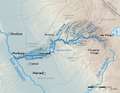
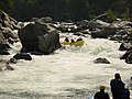
 | The Tuolumne River /tuˈɒləmi/ (Yokutsan: Tawalimnu) flows for 149 miles (240 km) through Central California, from the high Sierra Nevada to join the San... 70 KB (7,726 words) - 19:40, 6 March 2024 |
 | Tuolumne Meadows (/tuˈɒləmi/) is a gentle, dome-studded, sub-alpine meadow area along the Tuolumne River in the eastern section of Yosemite National Park... 12 KB (1,004 words) - 17:34, 9 April 2024 |
Tuolumne may refer to: Tuolumne River, one of the major rivers draining the western slope of the Sierra Nevada mountains Tuolumne Grove, of giant sequoia... 621 bytes (111 words) - 16:19, 25 December 2023 |
 | Creek Tuolumne River Dry Creek New Don Pedro Dam, Lake Don Pedro Moccasin Creek Sullivan Creek Woods Creek North Fork Tuolumne River Clavey River Hull... 69 KB (5,980 words) - 23:42, 17 February 2024 |
 | Hetch Hetchy (category Tuolumne River) the northwestern part of Yosemite National Park and is drained by the Tuolumne River. For thousands of years before the arrival of settlers from the United... 62 KB (6,693 words) - 10:32, 28 April 2024 |
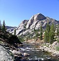
 | Canyon of the Tuolumne is the notable canyon section of the river valley of the Tuolumne River, located within Yosemite National Park, in Tuolumne County and... 5 KB (566 words) - 01:19, 7 January 2024 |
 | from this mountain drains south to the Tuolumne River via Cherry Creek, and north to the Middle Fork Stanislaus River via Relief and Summit creeks. The landform's... 4 KB (320 words) - 00:55, 9 January 2023 |
The Tuolumne River Regional Park is a large urban park under development along a seven-mile (11 km) stretch of the Tuolumne River between the cities of... 7 KB (946 words) - 15:28, 29 February 2024 |
 | River is a tributary of the Tuolumne River in the Sierra Nevada, located in the Stanislaus National Forest and Tuolumne County, California. The river... 8 KB (588 words) - 14:14, 29 September 2021 |
 | Tuolumne Grove is a giant sequoia grove located near Crane Flat in Yosemite National Park, at the southeastern edge of the Tuolumne River watershed. It... 3 KB (167 words) - 22:15, 6 October 2021 |
 | O'Shaughnessy Dam (California) (category Dams on the Tuolumne River) (131 m) high concrete arch-gravity dam in Tuolumne County, California, United States. It impounds the Tuolumne River, forming the Hetch Hetchy Reservoir at... 43 KB (4,446 words) - 16:00, 6 April 2024 |
 | 46361°W / 37.66361; -120.46361 (37.6635433, -120.4635289) along the Tuolumne River, and is near the La Grange Dam and the New Don Pedro Dam. The name is... 6 KB (649 words) - 22:04, 26 July 2023 |
 | High Sierra Camps (section Tuolumne Meadows Lodge) Peak is also nearby. The Glen Aulin High Sierra Camp is located on the Tuolumne River at an elevation of 7,800 feet (2,400 m), and was one of the original... 16 KB (2,193 words) - 01:32, 26 January 2024 |
 | Mount Lyell "2008 Pack Stock Use Assessment in Subalpine Meadows of the Tuolumne River Watershed" (PDF). NPS. Retrieved 1 February 2019. Equine trekking, through... 1 KB (104 words) - 20:33, 24 September 2022 |
 | Little Devils Postpile (category Tuolumne River) south in the Sierra Nevada. It is located along the Tuolumne River, several miles west of Tuolumne Meadows. List of places with columnar jointed volcanics... 1 KB (125 words) - 11:04, 11 February 2024 |
 | Lembert Dome (category Landforms of Tuolumne County, California) 800 feet (240 m) above Tuolumne Meadows and the Tuolumne River and can be hiked starting at the Tioga Road in the heart of Tuolumne Meadows, 8 miles (13 km)... 4 KB (331 words) - 05:27, 28 March 2024 |
 | the Sierra Nevada mountain range, and is the largest tributary of the Tuolumne River. The creek is 44.6 miles (71.8 km) long measured to its farthest headwaters;... 12 KB (1,328 words) - 19:46, 2 February 2024 |
 | watercourses include the Stanislaus River, the Tuolumne River and Dry Creek which empties into the Tuolumne River. Area groundwater, which is the principal... 99 KB (9,362 words) - 03:06, 23 April 2024 |
 | Dana Meadows (California) (category Landforms of Tuolumne County, California) foot of Mount Dana, not far from Tuolumne Meadows and the Tioga Pass entrance station. The Dana Fork of the Tuolumne River originates adjacent to the meadows... 2 KB (267 words) - 02:30, 2 February 2019 |
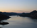 | Don Pedro Reservoir (category Tuolumne River) formed by the construction of the New Don Pedro Dam across the Tuolumne River in Tuolumne County, California, United States. The California Office of Environmental... 9 KB (736 words) - 12:51, 8 February 2024 |
 | the Stanislaus and Tuolumne Rivers. Suenumne - Lower Stanislaus River. Tuolumne - Lower Stanislaus River. Ausumne - Lower Merced River. Chulumne - Sand... 27 KB (2,959 words) - 06:54, 5 April 2024 |
 | Jacksonville, California (category History of Tuolumne County, California) in 1924. Jacksonville was founded by farmer Julian Smart along the Tuolumne River at an elevation of 800 feet . In spring 1849, Smart planted a garden... 3 KB (206 words) - 16:13, 18 March 2024 |
 | The North Fork Tuolumne River is a 35.7-mile (57.5 km) long river in the central Sierra Nevada of Tuolumne County, California and is a major tributary... 5 KB (331 words) - 19:57, 26 February 2023 |
 | Stanislaus, Tuolumne, and Merced River tributaries). The southern third of the range is drained by the Kings, Kaweah, Tule, and Kern rivers, which flow... 70 KB (7,049 words) - 10:52, 28 April 2024 |
 | (1 January 2016). "The giant, spike-toothed salmon, and the "Proto-Tuolumne River" (early Pliocene) of Central California". PaleoBios. 33: 13. doi:10... 10 KB (977 words) - 08:30, 29 February 2024 |
 | (0.10 km2) of it (1.72%) is water. The city was founded around the Tuolumne River. City population signs report Waterford's elevation is 51 feet (16 m)... 17 KB (1,528 words) - 15:53, 8 September 2023 |
 | Nevada. To the north it is bordered by the watershed of the Tuolumne River, the other major river draining Yosemite National Park. On the south, the Merced... 45 KB (5,131 words) - 18:17, 19 January 2024 |
 | its largest tributary, the Tuolumne. Near Vernalis, it is joined by another major tributary, the Stanislaus River. The river passes between Manteca and... 126 KB (14,226 words) - 20:10, 10 December 2023 |
Tuolumne City is a former settlement on the Tuolumne River, originally in Tuolumne County, during the California Gold Rush. The site has been in Stanislaus... 2 KB (186 words) - 01:56, 28 June 2022 |
an oceanic plate, which eventually resulted in the accretion of the Tuolumne River and Slate Creek terranes to North America. This is analogous to the... 16 KB (2,022 words) - 02:24, 21 March 2024 |