 | 38.02; -119.94 Tuolumne County (/tuˈɒləmi/ ), officially the County of Tuolumne, is a county located in the U.S. state of California. As of the 2020... 50 KB (2,127 words) - 15:29, 23 April 2024 |
 | Tuolumne City (/tuˈɒləmi/ ) is an unincorporated town in Tuolumne County, California. A census-designated place (CDP) officially known as Tuolumne also... 16 KB (1,577 words) - 22:53, 21 February 2024 |
 | Sonora is the county seat of Tuolumne County, California, United States. Founded during the California Gold Rush by Mexican miners from Sonora (after which... 26 KB (2,112 words) - 01:19, 14 April 2024 |
community and a census-designated place (CDP) in Tuolumne County, California. Strawberry is located on California State Route 108 10 miles (16 km) northeast... 7 KB (680 words) - 22:43, 21 February 2024 |
 | 320-foot-elevation (3,146 meter) mountain summit located in Tuolumne County, California, United States. Granite Dome is set within the Emigrant Wilderness... 4 KB (320 words) - 00:55, 9 January 2023 |
The Tuolumne Band of Me-Wuk Indians is a federally recognized tribe of Miwok people in Tuolumne County, California. The Tuolumne Band are central Sierra... 6 KB (555 words) - 20:32, 6 April 2024 |
 | The Tuolumne River /tuˈɒləmi/ (Yokutsan: Tawalimnu) flows for 149 miles (240 km) through Central California, from the high Sierra Nevada to join the San... 70 KB (7,726 words) - 19:16, 29 April 2024 |
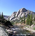
 | Tuolumne Meadows (/tuˈɒləmi/) is a gentle, dome-studded, sub-alpine meadow area along the Tuolumne River in the eastern section of Yosemite National Park... 12 KB (1,004 words) - 17:34, 9 April 2024 |
This is a list of school districts in California. California school districts are of several varieties, usually a Unified district, which includes all... 58 KB (5,117 words) - 03:41, 9 May 2024 |
 | Chinese Camp is a census-designated place (CDP) in Tuolumne County, California, United States. The population was 126 at the 2010 census, down from 146... 19 KB (1,657 words) - 21:17, 3 May 2024 |
 | Cherokee, California is a historical mining town site in Tuolumne, California in Tuolumne County, California. The site of the Cherokee, California is a California... 3 KB (291 words) - 01:51, 13 October 2023 |
Major intersections County Route J20 (CR J20) was a county highway in Tuolumne and Mariposa counties in the U.S. state of California. It ran from its western... 117 KB (4,843 words) - 16:47, 19 December 2023 |
 | Area codes 209 and 350 (category Tuolumne County, California) Ridge Pine Mountain Lake Sonora Soulsbyville Strawberry Tuolumne City Twain Harte List of California area codes "Planning Letter PL-556: Transition to 10-digit... 12 KB (640 words) - 16:11, 8 May 2024 |
 | foot of Mount Dana, not far from Tuolumne Meadows and the Tioga Pass entrance station. The Dana Fork of the Tuolumne River originates adjacent to the... 2 KB (268 words) - 02:19, 6 May 2024 |
 | the Tuolumne is the notable canyon section of the river valley of the Tuolumne River, located within Yosemite National Park, in Tuolumne County and the... 5 KB (566 words) - 01:19, 7 January 2024 |
 | after the Stanislaus River. The forest is located primarily in eastern Tuolumne County, adjacent to the northwestern part of Yosemite National Park, but parts... 5 KB (427 words) - 20:18, 24 December 2023 |
 | California is a historical farming town site in Chinese Camp, California in Tuolumne County, California. The site of the Jacksonville, California is... 3 KB (206 words) - 16:13, 18 March 2024 |
 | elevation gain when starting from the Tuolumne Wilderness Office. The hike is easy from Tuolumne Meadows, following the Tuolumne River to the head of the Lyell... 8 KB (680 words) - 00:18, 9 October 2023 |
Tuolumne County, California, located in the Sierra Nevada Tuolumne City, California, an unincorporated community in Tuolumne County "Tuolumne", a song by Eddie... 621 bytes (111 words) - 16:19, 25 December 2023 |
 | in Tuolumne County, California, United States. The population was 3,433 at the 2010 census, up from 3,017 at the 2000 census. Formerly a California Gold... 11 KB (1,105 words) - 09:37, 11 November 2023 |
 | Twain Harte is a census-designated place (CDP) in Tuolumne County, California, United States. The population was 2,226 at the 2010 census, down from 2... 13 KB (1,216 words) - 01:52, 16 April 2024 |
properties and districts listed on the California Historical Landmark listing in Tuolumne County, California. Click the "Map of all coordinates" link... 7 KB (105 words) - 03:21, 13 October 2023 |
 | Soulsbyville is an unincorporated census-designated place in Tuolumne County, California. The population was 2,215 at the time of the 2010 census, up... 12 KB (1,083 words) - 21:35, 13 July 2023 |
community in Tuolumne County, in the U.S. state of California. U.S. Geological Survey Geographic Names Information System: Yankee Hill, Tuolumne County, California... 2 KB (32 words) - 06:08, 27 July 2023 |
 | Groveland is a census-designated place (CDP) in Tuolumne County, California. Groveland sits at an elevation of 3,136 feet (956 m). The 2020 United States... 13 KB (902 words) - 04:45, 19 April 2024 |
Strawberry, California may refer to: Strawberry, El Dorado County, California Strawberry, Marin County, California Strawberry, Tuolumne County, California This... 186 bytes (52 words) - 05:34, 30 December 2019 |
 | districts listed on the National Register of Historic Places in the 58 counties of California, including 145 designated as National Historic Landmarks. The following... 18 KB (381 words) - 20:53, 8 April 2024 |
 | Ahwahnee, before crossing into Mariposa County. State Route 49 then continues northward through the counties of Tuolumne, Calaveras, Amador, El Dorado, Placer... 36 KB (2,930 words) - 12:41, 26 April 2024 |
 | Moccasin, an unincorporated community in Tuolumne County, California, is located at the intersection of State Route 49 and State Route 120. The community... 8 KB (737 words) - 14:26, 23 April 2024 |
Commerce. "Smith Peak, California". Peakbagger.com. "Smith Peak". SummitPost.org. Retrieved 2016-03-28. Gudde, Erwin G. (1949). California Place Names. Berkeley:... 2 KB (115 words) - 06:04, 6 May 2024 |