 | The United States Geological Survey (USGS), founded as the Geological Survey, is an agency of the United States government whose work spans the disciplines... 34 KB (3,664 words) - 17:46, 1 April 2024 |
A geological survey is the systematic investigation of the geology beneath a given piece of ground for the purpose of creating a geological map or model... 4 KB (445 words) - 15:41, 14 June 2022 |
 | States Geological Survey, United States Department of the Interior. "Lone Mountain". Geographic Names Information System. United States Geological Survey, United... 168 KB (13,958 words) - 21:44, 19 March 2024 |
| The United States Geological Survey Library (USGS Library) is a program within the United States Geological Survey (USGS), a scientific bureau within the... 14 KB (1,634 words) - 03:15, 17 February 2024 |
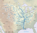 | segment of a river, as contrasted to its tributaries". The United States Geological Survey (USGS) defines a main-stem segment by listing coordinates for... 60 KB (3,151 words) - 02:06, 26 November 2023 |
 | Tapestry of Time and Terrain: The Union of Two Maps – Geology and Topography". United States Geological Survey. Archived from the original on May 15, 2006. Retrieved... 49 KB (5,606 words) - 00:06, 27 February 2024 |
January 2024). "M 7.5 - 2024 Noto Peninsula, Japan Earthquake". United States Geological Survey. Retrieved 1 January 2024. Ishikawa, Yuzo; Bai, Ling (2024)... 56 KB (2,677 words) - 13:39, 15 April 2024 |
 | The California Geological Survey, previously known as the California Division of Mines and Geology, is the California state geologic agency. Although... 8 KB (1,084 words) - 19:47, 21 October 2022 |
January 2023). "M 5.5 - 9 km ESE of Jayapura, Indonesia". United States Geological Survey. Archived from the original on 1 January 2023. Retrieved 4... 323 KB (17,576 words) - 03:13, 6 April 2024 |
 | United States Geological Survey. February 27, 1955. Retrieved July 26, 2021. "M 7.6 – Peru-Brazil border region". United States Geological Survey. August... 142 KB (4,422 words) - 21:12, 11 April 2024 |
 | List of mountain ranges in Wyoming (category Lists of mountain ranges of the United States) Geological Survey, United States Department of the Interior. "The Vees". Geographic Names Information System. United States Geological Survey, United... 25 KB (5,401 words) - 09:57, 23 July 2023 |
 | material from "Geologic Provinces of the United States: Records of an Active Earth". USGS Geology in the Parks. United States Geological Survey. Archived from... 51 KB (6,773 words) - 02:23, 10 March 2024 |
 | March 14, 2023. "USGS GNIS query". United States Board on Geographic Names, United States Geological Survey, United States Department of the Interior. Seaport... 15 KB (475 words) - 02:25, 15 April 2024 |
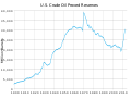 | Energy Information Administration using data compiled by the United States Geological Survey under the Department of the Interior estimated US undiscovered... 17 KB (1,964 words) - 00:04, 25 February 2024 |
landmass United States Geological Survey, a government scientific research agency which studies the landscape of the United States Astronomical survey, imaging... 3 KB (463 words) - 13:33, 1 November 2023 |
 | Appalachian Basin Coal Regions (PDF). United States Geological Survey. "The Sedimentary Appalachians". NYC Regional Geology. Archived from the original on May... 23 KB (2,594 words) - 21:26, 10 April 2024 |
The United States Geological Survey National Volcanic Threat Assessment is a report containing a ranked list of active volcanoes in the United States posing... 18 KB (336 words) - 19:35, 11 April 2024 |
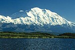
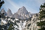 | List of mountain peaks of California (category Lists of mountains of the United States) Geodetic Survey. Retrieved 8 June 2016. "Mount Whitney". Geographic Names Information System. United States Geological Survey, United States Department... 54 KB (5,512 words) - 00:21, 24 February 2024 |
 | 2010. "United States Penitentiary in Leavenworth Cemetery". Geographic Names Information System. United States Geological Survey, United States Department... 15 KB (1,826 words) - 10:56, 10 February 2024 |
June 2023). "M 5.9 - 82 km SSW of Bambanglipuro, Indonesia". United States Geological Survey. Retrieved 30 June 2023. National Earthquake Information Center... 46 KB (1,921 words) - 17:20, 4 April 2024 |
| map of the United States in 1850. The National Program for Topographic Mapping was initiated in 1884 by the United States Geological Survey (USGS). Geography... 2 KB (176 words) - 21:15, 15 April 2024 |
 | of the United States Mean center of the United States population Median center of the United States population United States Geological Survey (USGS)... 11 KB (1,279 words) - 02:44, 25 November 2023 |
2023 based on data by the United States Geological Survey (USGS). List of silver mines "Silver" (PDF). U.S. Geological Survey, Mineral Commodity Summaries... 2 KB (39 words) - 10:57, 24 February 2024 |
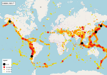
 | earthquake reports". United States Geological Survey. Retrieved 2017-05-10. "Earthquake Statistics". United States Geological Survey. Retrieved 2017-05-10... 177 KB (7,958 words) - 00:11, 23 March 2024 |
 | domain material from "Rocky Mountains". Geologic Provinces of the United States. United States Geological Survey. Archived from the original on 2006-09-22... 18 KB (2,187 words) - 06:02, 13 December 2023 |
 | List of the highest major summits of Colorado (category Lists of mountains of the United States) Geodetic Survey. Retrieved 18 May 2016. "Mount Elbert". Geographic Names Information System. United States Geological Survey, United States Department... 40 KB (7,379 words) - 05:07, 14 December 2023 |
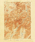 | Quadrangle (geography) (redirect from United States Geological Survey quadrangle) "quadrangle" is a topographic map produced by the United States Geological Survey (USGS) covering the United States. The maps are usually named after local physiographic... 4 KB (361 words) - 01:11, 20 August 2023 |
 | of western United States (1931), and Physiography of eastern United States (1938). "Physiographic Regions". United States Geological Survey. 2003-04-17... 10 KB (427 words) - 10:06, 22 December 2023 |
United States Geological Survey. January 10, 2021. Retrieved January 10, 2021. "M 4.3 - 11 km W of Kalecik, Turkey". United States Geological Survey.... 257 KB (11,928 words) - 13:28, 6 March 2024 |
 | The Hayden Geological Survey of 1871 explored the region of northwestern Wyoming that later became Yellowstone National Park in 1872. It was led by geologist... 38 KB (5,214 words) - 09:05, 8 April 2024 |