
The United States Geological Survey (USGS), founded as the Geological Survey, is an agency of the United States government whose work spans the disciplines...
35 KB (3,773 words) - 22:52, 12 July 2024
A geological survey is the systematic investigation of the geology beneath a given piece of ground for the purpose of creating a geological map or model...
4 KB (445 words) - 15:41, 14 June 2022
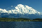
States Geological Survey, United States Department of the Interior. "Lone Mountain". Geographic Names Information System. United States Geological Survey, United...
166 KB (13,958 words) - 19:07, 19 July 2024

The California Geological Survey, previously known as the California Division of Mines and Geology, is the California state geologic agency. Although...
8 KB (1,084 words) - 19:47, 21 October 2022
The United States Geological Survey Library (USGS Library) is a program within the United States Geological Survey (USGS), a scientific bureau within the...
14 KB (1,634 words) - 03:15, 17 February 2024
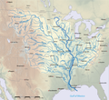
segment of a river, as contrasted to its tributaries". The United States Geological Survey (USGS) defines a main-stem segment by listing coordinates for...
60 KB (3,176 words) - 22:31, 23 June 2024
The United States Geological Survey National Volcanic Threat Assessment is a report containing a ranked list of active volcanoes in the United States posing...
18 KB (336 words) - 19:35, 11 April 2024
Tapestry of Time and Terrain: The Union of Two Maps – Geology and Topography". United States Geological Survey. Archived from the original on May 15, 2006. Retrieved...
49 KB (5,624 words) - 23:03, 18 July 2024

material from "Geologic Provinces of the United States: Records of an Active Earth". USGS Geology in the Parks. United States Geological Survey. Archived from...
51 KB (6,773 words) - 08:52, 14 July 2024
Kentucky. It is one of the United States's oldest geological organizations, pre-dating the United States Geological Survey by 25 years. It has worked...
11 KB (1,485 words) - 16:02, 7 April 2024
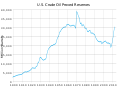
Energy Information Administration using data compiled by the United States Geological Survey under the Department of the Interior estimated US undiscovered...
17 KB (1,965 words) - 08:40, 21 April 2024
of the United States Mean center of the United States population Median center of the United States population United States Geological Survey (USGS)...
11 KB (1,285 words) - 02:40, 23 May 2024

March 14, 2023. "USGS GNIS query". United States Board on Geographic Names, United States Geological Survey, United States Department of the Interior. Seaport...
15 KB (473 words) - 16:05, 6 July 2024

2010. "United States Penitentiary in Leavenworth Cemetery". Geographic Names Information System. United States Geological Survey, United States Department...
15 KB (1,847 words) - 07:33, 26 July 2024
January 2023). "M 5.5 - 9 km ESE of Jayapura, Indonesia". United States Geological Survey. Archived from the original on 1 January 2023. Retrieved 4...
323 KB (17,578 words) - 02:25, 7 July 2024
Quadrangle (geography) (redirect from United States Geological Survey quadrangle)
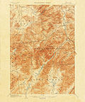
"quadrangle" is a topographic map produced by the United States Geological Survey (USGS) covering the United States. The maps are usually named after local physiographic...
4 KB (361 words) - 01:11, 20 August 2023

of western United States (1931), and Physiography of eastern United States (1938). "Physiographic Regions". United States Geological Survey. 2003-04-17...
10 KB (427 words) - 19:51, 11 July 2024

Appalachian Basin Coal Regions (PDF). United States Geological Survey. "The Sedimentary Appalachians". NYC Regional Geology. Archived from the original on May...
23 KB (2,593 words) - 16:15, 12 June 2024

The director of the U.S. Geological Survey (USGS) is responsible for direction and leadership of the agency. Within the director's office are the deputy...
6 KB (399 words) - 22:02, 4 June 2024

Mount Erebus (section Geology and volcanology)
United States Geological Survey, United States Department of the Interior "The Fang", Geographic Names Information System, United States Geological Survey...
40 KB (5,669 words) - 23:37, 18 June 2024
Colorado State Geological Survey publishes first geological map and report. 1916 – The name is changed to the Colorado Geological Survey. 1925 – The Colorado...
5 KB (509 words) - 20:19, 20 July 2024

The United States Coast and Geodetic Survey (abbreviated USC&GS; known as the Survey of the Coast from 1807 to 1836; as the United States Coast Survey from...
103 KB (11,240 words) - 20:57, 17 July 2024

The Hayden Geological Survey of 1871 explored the region of northwestern Wyoming that later became Yellowstone National Park in 1872. It was led by geologist...
38 KB (5,214 words) - 09:05, 8 April 2024
map of the United States in 1850. The National Program for Topographic Mapping was initiated in 1884 by the United States Geological Survey (USGS). Geography...
2 KB (176 words) - 04:43, 26 July 2024
List of U.S. places named after non-U.S. places (category Lists of United States placename etymology)
United States Geologic Survey. "Bastogne Gables, North Carolina". Geographic Names Information System. United States Geological Survey, United States...
138 KB (3,623 words) - 14:34, 23 July 2024
area British Geological Survey, a body which carries out geological surveys and monitors the UK landmass United States Geological Survey, a government...
3 KB (486 words) - 23:04, 20 July 2024

domain material from "Rocky Mountains". Geologic Provinces of the United States. United States Geological Survey. Archived from the original on 2006-09-22...
18 KB (2,187 words) - 19:48, 11 July 2024
List of mountain peaks of California (category Lists of mountains of the United States)
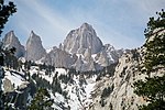
Geodetic Survey. Retrieved 8 June 2016. "Mount Whitney". Geographic Names Information System. United States Geological Survey, United States Department...
54 KB (5,512 words) - 00:21, 24 February 2024
United States Geological Survey, United States Department of the Interior. "Olean". Geographic Names Information System. United States Geological Survey...
24 KB (895 words) - 01:51, 3 April 2024
that the Michigan Geological Survey could concentrate on economic geology, Wadsworth arranged for the United States Geological Survey to assume responsibility...
26 KB (2,105 words) - 01:43, 11 December 2023