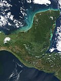
 | The Usumacinta River (Spanish pronunciation: [usumaˈsinta]; named after the howler monkey) is a river in southeastern Mexico and northwestern Guatemala... 11 KB (1,109 words) - 06:56, 6 January 2024 |
ARM Usumacinta may refer to one of the following vessels of the Mexican Navy named for the Usumacinta River: ARM Usumacinta (B06), the former American... 776 bytes (133 words) - 09:51, 22 September 2021 |
 | The Usumacinta mangroves ecoregion (WWF ID: NT1437) covers the mangrove forests ont the Gulf Coast of Mexico, around the margins of the Laguna de Términos... 5 KB (397 words) - 19:21, 9 March 2024 |
The Usumacinta sea catfish (Potamarius usumacintae) is a species of catfish in the family Ariidae. It was described by Ricardo Betancur-Rodriguez and Philip... 1 KB (86 words) - 22:16, 19 December 2021 |
 | Maya civilization (section Usumacinta) include Chicanná, Hormiguero, and Xpuhil. The Usumacinta style developed in the hilly terrain of the Usumacinta drainage. Cities took advantage of the hillsides... 183 KB (22,561 words) - 03:04, 1 March 2024 |
 | Poecilia kykesis (redirect from Usumacinta molly) Poecilia kykesis, also known as the Usumacinta molly, Petén molly, spiketail molly, or swordtail molly, is a poeciliid fish species native to the fresh... 10 KB (1,062 words) - 05:10, 10 February 2024 |
 | USS Frederick (LST-1184) (redirect from ARM Usumacinta (A412)) Assistance Program and entered service in December 2002 renamed ARM Usumacinta. Usumacinta has since taken part in three RIMPAC multi-national naval exercises... 14 KB (1,359 words) - 05:39, 23 March 2024 |
 | Cañón del Usumacinta is a protected natural area in southern Mexico. It protects part of the Usumacinta Canyon, where the Usumacinta River winds northwards... 2 KB (169 words) - 16:28, 27 October 2021 |
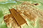
 | Yaxchilan (category Usumacinta River) (pronounced [ʝaʃtʃiˈlan]) is an ancient Maya city located on the bank of the Usumacinta River in the state of Chiapas, Mexico. In the Late Classic Period Yaxchilan... 47 KB (5,968 words) - 10:53, 9 May 2024 |
 | Tucson, who is part a research team started in 2017 called the Middle Usumacinta Archaeological Project. The site is located near the San Pedro River in... 7 KB (498 words) - 02:19, 26 September 2023 |
 | below is solely that of the main stem. In the case of the Grijalva and Usumacinta, it is the combined lengths of two river systems that share a delta. In... 18 KB (660 words) - 18:44, 10 January 2024 |
 | USS Don O. Woods (redirect from ARM Usumacinta (B06)) 1946. In 1963, she was transferred to Mexico, where she served as ARM Usumacinta/Miguel Hidalgo (B-06) until 2001. Don Otis Woods was born on 19 May 1922... 7 KB (542 words) - 17:22, 6 April 2023 |
 | USS Annapolis (PF-15) (redirect from ARM Río Usumacinta) State. Renamed ARM General Vicente Guerrero and later renamed ARM Rio Usumacinta, the ship was scrapped in 1964. This article incorporates text from the... 6 KB (560 words) - 19:29, 11 March 2023 |
 | of Campeche, Tabasco and Chiapas. The border includes stretches of the Usumacinta River, the Salinas River, and the Suchiate River. Geopolitically, this... 9 KB (1,005 words) - 10:33, 30 December 2023 |
 | unevenly distributed throughout the country. Indeed, five rivers—the Usumacinta, Grijalva, Papaloapán, Coatzacoalcos, and Pánuco—account for 52 percent... 34 KB (4,562 words) - 20:35, 12 May 2024 |
 | route through Cancuén river, which communicated with Petén through the Usumacinta River on the border with Mexico and the only road that existed was a dirt... 227 KB (27,540 words) - 13:25, 23 April 2024 |
 | Kab 101 (section Usumacinta accident timeline) independent studies of the accident. October 21, 2007: The jackup rig Usumacinta is moved to the location of Kab 101 to prepare for work on the well Kab... 7 KB (790 words) - 23:34, 2 November 2022 |
 | suffering extensive deforestation. Mangroves occur along the coast, with the Usumacinta mangroves around the Laguna de Términos in the southwest, the Petenes... 25 KB (2,520 words) - 01:55, 23 February 2024 |
 | art and monumental architecture. The Mayan city of Yaxchilan, on the Usumacinta River in present-day southern Mexico, specialized in the stone carving... 10 KB (1,128 words) - 14:31, 18 December 2023 |
 | Lacandon Jungle (category Usumacinta River) Dividing the Chiapas part of the forest from the Guatemalan side is the Usumacinta River, which is the largest river in Mexico and the seventh largest in... 45 KB (5,806 words) - 14:45, 15 February 2024 |
 | states of Campeche, Tabasco and Chiapas, and includes stretches of the Río Usumacinta, Río Salinas and Río Suchiate. Five nations and Mexico share a marine... 3 KB (255 words) - 21:11, 14 May 2024 |
 | suspension bridge believed to have been built by the Maya across the Usumacinta River, Chiapas, Mexico. If so, it would have been the longest bridge discovered... 4 KB (528 words) - 13:50, 4 May 2024 |
 | 400 km2 (51,900 sq mi) in size. Because of the close connection to the Usumacinta River (the two combine, flowing into the Gulf of Mexico in a single delta)... 5 KB (457 words) - 15:01, 28 March 2024 |
 | the area of Petén in Guatemala. Flowing within the Rainforest is the Usumacinta River, considered to be one of the largest rivers in Mexico and seventh... 198 KB (23,218 words) - 23:04, 8 May 2024 |
 | other buffalofish species: the fleshylip buffalo found in Mexico, or the usumacinta buffalo found in Mexico and Guatemala. Buffalofish are not carp, nor is... 9 KB (908 words) - 20:16, 4 January 2024 |
 | documentation. The two major regions are called the Grijalva and the Usumacinta. The Grijalva Region is named after the river on which most of the municipalities... 82 KB (8,011 words) - 15:40, 20 April 2024 |
 | bank of the Usumacinta River in the Petén department of northwestern Guatemala. Piedras Negras is one of the most powerful of the Usumacinta ancient Maya... 20 KB (2,489 words) - 14:34, 3 May 2024 |
 | listed. The Usumacinta mangroves extend around the edges of the lagoon where freshwater meets salt, and westward into the lower Usumacinta-Grijalva basin... 13 KB (1,511 words) - 19:01, 4 March 2024 |
"Proyecto de remodelación Restaurante Pollo Brujo, Heredia, Costa Rica". "Pollo Brujo -usumacinta Delivery in Villahermosa | Menu & Prices | Uber Eats". v t e... 1 KB (72 words) - 09:00, 5 March 2024 |
 | Pantanos de Centla (category Usumacinta River) states of Tabasco and Campeche. The Centla swamps occupy the delta of the Usumacinta and Grijalva rivers, which empty into the Gulf of Mexico and the Laguna... 7 KB (666 words) - 22:50, 12 April 2024 |