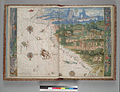
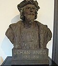
The Vallard Atlas is a world atlas, one of the Dieppe school of maps, produced in 1547. It is believed to have been owned by Nicolas Vallard, its authorship...
4 KB (499 words) - 13:43, 10 August 2023
The Vallard Atlas is an atlas produced in Dieppe, Northern France, in 1547. It was ascribed to Nicolas Vallard. However, there is a degree of uncertainty...
3 KB (390 words) - 20:34, 4 March 2023

2015. Retrieved 3 March 2022. First map of Australia from Nicholas Vallard's atlas, 1547, in the Library of Sir Thomas Phillipps, Bart. at Middle Hill...
67 KB (8,447 words) - 19:26, 8 April 2024
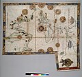
chart. c1547. British Library, London Anonymous, made for Nicholas Vallard, portolan atlas, c. 1547. Huntington Library, Los Angeles, California Pierre Desceliers...
74 KB (10,345 words) - 06:56, 10 February 2024
coast. Trickett uses one of the Dieppe maps in the highly decorated "Vallard" atlas of 1547 to demonstrate this. Trickett claims that Mendonça travelled...
16 KB (1,884 words) - 11:21, 16 April 2024

the superficial resemblance may have misled them. Terra Java in the Vallard Atlas of 1547, another product of the Dieppe school, bears the vestigial toponym...
25 KB (3,583 words) - 00:04, 3 December 2022
Sailing ship near Java la Grande in Vallard Atlas 1547, Dieppe school....
5 KB (481 words) - 17:57, 28 November 2023

on 7 November 2002. Museum of New Zealand – Te Papa ref B.024210 The Vallard Atlas, produced in early 17th century by the French and held in a Los Angeles...
88 KB (9,660 words) - 20:34, 25 February 2024

Sailing ship near Java la Grande in Vallard Atlas 1547, Dieppe school....
1 KB (128 words) - 18:27, 1 October 2018
Sailing ship near Java la Grande in Vallard Atlas 1547, Dieppe school....
1 KB (120 words) - 14:54, 12 December 2022

Jave La Grande's east coast: from Nicholas Vallard's atlas, 1547. This is part of an 1856 copy of one of the Dieppe Maps. Copy held by the National Library...
21 KB (3,072 words) - 07:07, 8 July 2023

Sailing ship near Java la Grande in Vallard Atlas 1547, Dieppe school...
58 KB (6,467 words) - 23:17, 2 February 2024
Alexipharmaka Tractatus de Herbis Universal Atlas of Diogo Homem Universal Atlas of Fernao Vaz Dourado Vallard Atlas Fonseca, Jesús. "Las joyas bibliográficas...
7 KB (862 words) - 21:42, 6 October 2022
Sailing ship near Java la Grande in Vallard Atlas 1547, Dieppe school....
2 KB (241 words) - 21:19, 20 September 2020

Jave La Grande's east coast: from Nicholas Vallard's atlas, 1547. Copy held by the National Library of Australia...
9 KB (991 words) - 11:53, 26 March 2024

General of Western Australia "First map of Australia from Nicholas Vallard's atlas, 1547, in the Library of Sir Thomas Phillipps, Bart. at Middle Hill...
9 KB (866 words) - 11:07, 6 March 2024

University of Chicago Press. ISBN 978-0-226-28510-8. Sunyoto, Agus (2017). Atlas Walisongo. South Tangerang: Pustaka IIMaN. Manguin, Pierre-Yves; Nicholl...
110 KB (11,823 words) - 15:03, 7 May 2024

Holy Cross Island, Rauchine Island, Kicheriniou Island, Réaumur Island, Vallard Island, Bélanger Island, Morain Island, Verreault Island, Thevet Island...
14 KB (1,687 words) - 13:55, 31 October 2023