 | Wahkiakum County (/wəˈkaɪ.əkʌm/) is a county located in the U.S. state of Washington. As of the 2020 census, the population was 4,422, making it one of... 16 KB (1,330 words) - 21:50, 26 April 2024 |
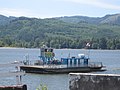 | The Wahkiakum County ferry crosses the lower Columbia River between the U.S. states of Washington and Oregon, and is the last regularly scheduled car... 9 KB (643 words) - 01:21, 10 September 2023 |
Wahkiakum County may refer to: Places Wahkiakum County, Washington Ships USS Wahkiakum County (LST-1162), a United States Navy landing ship tank in commission... 519 bytes (98 words) - 08:45, 19 June 2011 |
 | island and Census-designated place (CDP) in the Columbia River in Wahkiakum County, Washington, United States. The island was named for Peter Puget, a lieutenant... 7 KB (394 words) - 03:35, 27 September 2023 |
 | Spokane Stevens Thurston Wahkiakum Walla Walla Whatcom Whitman Yakima This is a list of properties and historic districts in Washington that are listed on the... 10 KB (567 words) - 19:07, 10 January 2024 |
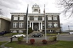
 | located along the Ocean Beach Highway in Wahkiakum County, Washington, United States, where it is the county seat. The population was 532 at the 2010... 17 KB (1,386 words) - 03:48, 26 February 2024 |
The Wahkiakum County Eagle is a weekly newspaper, originally founded in 1891, based in Cathlamet and covering Wahkiakum County in the U.S. state of Washington... 3 KB (347 words) - 05:19, 6 January 2024 |
 | East Cathlamet is a census-designated place (CDP) in Wahkiakum County, Washington, on the eastern border of the town of Cathlamet. The population was 491... 7 KB (710 words) - 03:26, 27 September 2023 |
 | Skamokawa (/skʌˈmɑːkəˌweɪ/) is an unincorporated community in Wahkiakum County, Washington, United States. Skamokawa Valley, a census-designated place (CDP)... 4 KB (127 words) - 04:06, 27 September 2023 |
 | Krist Novoselic (category People from Wahkiakum County, Washington) reform from its grassroots. In 2009, Novoselic ran for county clerk of Wahkiakum County, Washington, but later withdrew his candidacy. He had sought the... 77 KB (6,551 words) - 00:04, 14 April 2024 |
 | short Washington state highway in Wahkiakum County. The highway runs north from the Wahkiakum County Ferry on Puget Island to SR 4 in the county seat of... 15 KB (1,323 words) - 04:55, 16 February 2024 |
 | Giants in the Trees (category Alternative rock groups from Washington (state)) Giants in the Trees was an American rock band formed in Wahkiakum County, Washington, in 2017. The band was formed by former Nirvana bassist Krist Novoselic... 5 KB (410 words) - 17:51, 23 January 2024 |
 | counties of Lewis, Pacific, Wahkiakum, Cowlitz, Clark, and Skamania; as well as a small portion of southern Thurston county. The district is represented... 33 KB (1,121 words) - 23:02, 7 March 2024 |
 | Grays River Covered Bridge (category Transportation buildings and structures in Wahkiakum County, Washington) Grays River in western Wahkiakum County, Washington. It is the only covered bridge still in use as a public highway in Washington State. The bridge was... 7 KB (545 words) - 16:17, 12 February 2023 |
Deep River is a census-designated place (CDP) in Wahkiakum County, Washington, northwest of the town of Cathlamet and east of the city of Long Beach. In... 7 KB (523 words) - 03:23, 27 September 2023 |
Lower Elochoman is a census-designated place (CDP) in Wahkiakum County, Washington, United States. The population was 185 at the 2010 census. "Lower Elochoman... 3 KB (49 words) - 12:23, 21 July 2023 |
eastern Willapa Hills in Washington state's southwestern Pacific County. It flows generally southwesterly across western Wahkiakum County. The river has three... 9 KB (891 words) - 03:52, 7 December 2023 |
 | Pierce, Skamania, Thurston, and Wahkiakum counties). Washington Tourism Marketing Act HB 1938/ SB 5916 (PDF), Washington Tourism Alliance. "About Us". official... 8 KB (500 words) - 02:40, 11 June 2023 |
Census-designated place (CDP) in Wahkiakum County, Washington, United States. Rosburg is located on the Grays River near Washington State Route 4, 15 miles (24 km)... 4 KB (260 words) - 21:19, 13 July 2023 |
salmon-canning and fishing town located on the Columbia River in Wahkiakum County, Washington, United States, from 1873 to 1957. It was the home of the J.G... 9 KB (870 words) - 18:57, 30 September 2023 |
Upper Elochoman is a census-designated place (CDP) in Wahkiakum County, Washington, United States. The population was 193 at the 2010 census. The CDP includes... 3 KB (53 words) - 03:42, 27 September 2023 |
 | won every county except heavily unionized Grays Harbor and Pacific Counties, in the process being the first Republican to carry Wahkiakum County (another... 28 KB (252 words) - 22:21, 26 April 2024 |
Skamokawa Valley is a census-designated place (CDP) in Wahkiakum County, Washington, north of the town of Cathlamet. The population was 401 as of the 2010... 8 KB (646 words) - 20:15, 3 February 2024 |
known as Little Cape Horn, is an unincorporated community in Wahkiakum County, Washington. It is located on the Columbia River six miles east of Cathlamet... 4 KB (203 words) - 21:59, 14 April 2024 |
 | Washington, officially the State of Washington, is a state in the Pacific Northwest region of the United States. It is often referred to as Washington... 244 KB (18,866 words) - 15:31, 26 April 2024 |
 | 503 State Route 504 Lewis County - north Skamania County - east Clark County - south Wahkiakum County - west Columbia County - south Gifford Pinchot National... 20 KB (1,695 words) - 21:42, 26 April 2024 |
 | county by land area and fourth-smallest by total area. Wahkiakum County, Washington (northwest) Cowlitz County, Washington (northeast) Clark County,... 25 KB (2,208 words) - 18:39, 26 April 2024 |
 | Pierce, Yakima, Skamania, Cowlitz, Wahkiakum, and Pacific counties. According to the United States Census Bureau, the county has a total area of 2,436 square... 37 KB (3,427 words) - 21:46, 26 April 2024 |
 | Pioneer Church (category Buildings and structures in Wahkiakum County, Washington) known as the Congregational Church, is a historic church in Cathlamet, Washington. It was built in 1895 and added to the National Register of Historic Places... 2 KB (84 words) - 21:26, 8 August 2023 |
also including Wahkiakum County, Washington. Defined as the Spokane-Spokane Valley-Coeur d'Alene, WA-ID CSA and also including Benewah County, Idaho, Shoshone... 52 KB (5,526 words) - 22:13, 4 January 2024 |