 | A waituna is a freshwater coastal lagoon on a mixed sand and gravel (MSG) beach, formed where a braided river meets a coastline affected by longshore... 6 KB (737 words) - 05:41, 12 April 2024 |
Waituna West is a village and rural community in the Manawatū District and Manawatū-Whanganui region in New Zealand's central North Island. It is located... 4 KB (457 words) - 04:47, 25 March 2024 |
 | of a braided river where there are mixed sand and gravel beaches, while waituna, an ephemeral coastal waterbody, is neither a true lagoon, lake nor estuary... 17 KB (1,924 words) - 19:35, 9 March 2024 |
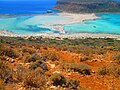
The Waituna Lagoon is on the southern coastline of the South Island of New Zealand. It forms part of the Awarua Wetland, a Ramsar site that was established... 6 KB (408 words) - 16:36, 20 August 2022 |
 | Lake Ellesmere / Te Waihora is a broad, shallow coastal lake or waituna, in the Canterbury region of the South Island of New Zealand. It is directly to... 18 KB (2,200 words) - 08:09, 25 April 2024 |
 | Submarine canyon Tidal island Tidal marsh Tide pool Tied island Tombolo Waituna Windwatt Beaches Beach cusps Beach evolution Coastal morphodynamics Beach... 34 KB (3,315 words) - 09:42, 25 April 2024 |
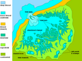
Awarua Wetland (redirect from Waituna Wetlands Scientific Reserve) international significance under the Ramsar Convention in 1976, using the name Waituna Wetlands Scientific Reserve. Conservation Minister Steve Chadwick unveiled... 4 KB (293 words) - 05:46, 12 April 2024 |
 | stretch of coast includes the peninsula of Tiwai Point, Awarua Bay, the Waituna Lagoon, and Toetoes Bay. The Mataura River is the major river responsible... 7 KB (770 words) - 02:58, 6 March 2024 |
 | 46°46′30″S 168°30′20″E / 46.77500°S 168.50556°E / -46.77500; 168.50556 Waituna Lagoon Southern Southland District East of Bluff 46°34′00″S 168°35′00″E... 165 KB (1,033 words) - 17:27, 12 April 2024 |
 | Submarine canyon Tidal island Tidal marsh Tide pool Tied island Tombolo Waituna Windwatt Beaches Beach cusps Beach evolution Coastal morphodynamics Beach... 13 KB (1,356 words) - 18:20, 15 March 2024 |
Makikihi Morven Otaio Saint Andrews Studholme Waihao Downs Waihaorunga Waituna Like much of rural New Zealand, Waimate suffered from an economic downturn... 17 KB (1,832 words) - 02:49, 9 February 2024 |
 | peninsula at the western end of the bay, on the edge of Bluff harbour. Waituna Lagoon is located halfway along the bay, and towards the eastern end the... 2 KB (199 words) - 06:41, 12 April 2024 |
 | Lake Grassmere / Kapara Te Hau is a New Zealand waituna-type lagoon in the northeastern South Island, close to Cook Strait. The lake is used for the production... 8 KB (982 words) - 05:40, 12 April 2024 |
 | Submarine canyon Tidal island Tidal marsh Tide pool Tied island Tombolo Waituna Windwatt Beaches Beach cusps Beach evolution Coastal morphodynamics Beach... 16 KB (1,697 words) - 20:05, 5 March 2024 |
 | Waitara WT 067 Waitati WTI 024 22 Waiterimu WTE 0817 65 Waitoa WTO 0819 21 Waituna West WNL 063 286 Waiuku WKU 085 Wakanui WNU 053 23 Wakefield WLD 054 Walton... 35 KB (1,824 words) - 03:38, 5 May 2024 |
 | West Cape (Te Waituna) Māori: Te Waituna Cape West Cape & Newton River Mouth, Fiordland, New Zealand West Cape (Te Waituna) Location of West Cape (Te Waihuna)... 3 KB (138 words) - 07:03, 13 April 2024 |
 | Submarine canyon Tidal island Tidal marsh Tide pool Tied island Tombolo Waituna Windwatt Beaches Beach cusps Beach evolution Coastal morphodynamics Beach... 11 KB (1,546 words) - 10:43, 22 August 2022 |
 | Submarine canyon Tidal island Tidal marsh Tide pool Tied island Tombolo Waituna Windwatt Beaches Beach cusps Beach evolution Coastal morphodynamics Beach... 4 KB (430 words) - 19:56, 7 March 2024 |
 | Island. It flows south from its source in Titirangi, meets the tributaries Waituna Stream and Waiohua Creek which run through the suburbs of Waima and Woodlands... 7 KB (551 words) - 00:05, 4 April 2024 |
 | Submarine canyon Tidal island Tidal marsh Tide pool Tied island Tombolo Waituna Windwatt Beaches Beach cusps Beach evolution Coastal morphodynamics Beach... 67 KB (8,003 words) - 23:11, 28 April 2024 |
Kapuka on the Southern Scenic Route. To the south are Toetoes Bay and Waituna Lagoon; Rimu is to the north. Mokotua was once a railway terminus. On 16... 2 KB (288 words) - 06:41, 12 April 2024 |
 | differentiates hapua from similar lagoons located on the New Zealand coast termed waituna. Hapua are often located on paraglacial coastal areas where there is a... 15 KB (2,224 words) - 05:40, 12 April 2024 |
Southland region of New Zealand's South Island. It is in a rural setting near Waituna and Woodlands to the north, Rimu to the west, and to the south on the Southern... 1 KB (154 words) - 04:38, 25 March 2024 |
34°27′20″S 172°48′00″E / 34.45556°S 172.80000°E / -34.45556; 172.80000 Waituna Lagoon Awarua Plain Southland Foveaux Strait 46°34′00″S 168°35′25″E /... 7 KB (34 words) - 00:20, 15 April 2024 |
Other nearby settlements are Rakahouka to the northwest and Rimu and Waituna to the south. Woodlands is defined by Statistics New Zealand as a rural... 6 KB (624 words) - 03:35, 5 March 2024 |
region of New Zealand's South Island. It is situated on Toetoes Bay and Waituna Lagoon. Kapuka and Ashers are to the north on the Southern Scenic Route... 2 KB (191 words) - 04:32, 25 March 2024 |
chain of lagoons along the east and south coast of the island, including Waituna, Wainono and Washdyke Lagoons, Coopers Lagoon / Muriwai, and Lake Ellesmere... 22 KB (2,867 words) - 08:11, 25 April 2024 |
Waimate State 4 306 [133] 362 Waimate Main School 1–6 Coed Waimate State 2 88 [134] 3574 Waituna Creek School 1–8 Coed Waituna State 5 28 [135] 3579... 45 KB (926 words) - 02:48, 12 November 2023 |
Coed Tangimoana State 2 20 [68] 2461 Taonui School 1–8 Coed Feilding State 5 45 [69] 2462 Waituna West School 1–8 Coed Waituna West State 7 51 [70] 2475... 61 KB (885 words) - 05:37, 22 September 2023 |
the Southern Scenic Route; Oteramika is to the north, and Kapuka South, Waituna Lagoon, and Toetoes Bay are to the south. Agriculture figures prominently... 3 KB (362 words) - 04:32, 25 March 2024 |