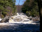
 | Walloomsac River (/ˈwɑːluːmsæk, ˈwælʊmsɪk/) from the Native American name, Wal-loom-sac is a 16.8-mile-long (27.0 km) tributary of the Hoosic River in... 5 KB (536 words) - 18:33, 28 October 2023 |
Walloomsac may refer to: Walloomsac, New York, a location in New York State Walloomsac River, a tributary of the Hoosic River This disambiguation page... 154 bytes (55 words) - 19:40, 30 December 2019 |
 | (23 km) above the city of Troy. North Branch Hoosic River Green River Little Hoosick River Walloomsac River - Native American name, also Wal-loom-sac Owl Kill... 7 KB (460 words) - 18:10, 21 October 2023 |
 | Lansing Kill Haynes Brook Blue Brook Hoosic River Tomhannock Creek Owl Kill Walloomsac River Little Hoosic River Fish Creek Kayaderosseras Creek Glowegee... 44 KB (3,593 words) - 04:13, 20 January 2024 |
 | water. Bennington is drained by the Walloomsac River and its tributaries, flowing to the Hoosic and then the Hudson River. The town is located along the western... 46 KB (4,540 words) - 07:32, 8 May 2024 |
 | Hoosic River, Schaghticoke, New York Walloomsac River, Hoosick, New York Roaring Branch, Bennington Batten Kill, Greenwich, New York Green River, West... 9 KB (534 words) - 21:48, 5 May 2023 |
 | The East River is a saltwater tidal estuary or strait in New York City. The waterway, which is actually not a river despite its name, connects Upper New... 74 KB (9,218 words) - 18:49, 30 April 2024 |
 | Walloomsac River, while the northeastern corner, including Lake Shaftsbury, drains north to the Batten Kill. Both rivers are part of the Hudson River... 13 KB (1,040 words) - 19:22, 30 March 2024 |
Glastenbury River. The southwest end of Glastenbury Mtn. drains into Bolles Brook, thence into the Roaring Branch of the Walloomsac River, the Hoosic River, the... 3 KB (247 words) - 01:30, 25 March 2023 |
 | Walloomsac, New York is a location in New York State, on the Walloomsac River. It is to the east, and upstream, from North Hoosick, New York. It includes... 1 KB (111 words) - 09:19, 17 August 2021 |
Sacandaga River Saranac River Susquehanna River Taghkanic Creek Taughannock Falls State Park Tioughnioga River Tonawanda Creek Walloomsac River Willowemoc... 8 KB (458 words) - 23:20, 2 May 2024 |
 | Jersey Palisades or the Hudson River Palisades, are a line of steep cliffs along the west side of the lower Hudson River in Northeastern New Jersey and... 21 KB (2,122 words) - 23:29, 19 November 2023 |
 | Covered Bridge is a covered bridge, carrying Silk Road across the Walloomsac River between downtown Bennington, Vermont and the village of North Bennington... 4 KB (377 words) - 17:54, 24 September 2022 |
 | drains into the Walloomsac River of Bennington, then west to the Hudson River, while the eastern half of the town drains to the Deerfield River, a tributary... 8 KB (606 words) - 00:41, 6 May 2024 |
downtown area of the town of Bennington, ranging from the Walloomsac River/Roaring Branch/Walloomsac Brook on the north, to the village of Old Bennington and... 6 KB (540 words) - 21:34, 7 July 2023 |
 | Batten Kill (redirect from Battenkill River) rather than by geographic regions." p77 Basin 1 - Batten Kill, Walloomsac River & Hoosic River Watersheds, Water Quality and Aquatic Habitat Assessment Report... 11 KB (1,264 words) - 21:47, 28 June 2022 |
(Abnaki) "mushy/quaky land" Ottauquechee River: (uncertain – Natick?) "swift mountain stream" Walloomsac River Popasquash Island Queneska Island: (Abnaki)... 108 KB (8,688 words) - 12:39, 8 May 2024 |
 | town of Shaftsbury. The southern border of the village follows the Walloomsac River. Vermont Route 67 passes through the village, leading northeast to... 12 KB (994 words) - 07:24, 8 May 2024 |
 | is in the water / is actively submerged"] is a waterfall on the Mohawk River shared by the city of Cohoes and the town of Waterford, New York. Cohoes... 7 KB (789 words) - 17:15, 10 April 2024 |
 | covered bridge that spans the Walloomsac River near Bennington, Vermont. A Town lattice truss bridge, it carries River Road, just south of the village... 4 KB (342 words) - 19:05, 2 December 2023 |
Walker River – Nevada Walla Walla River – Washington Wallkill River – New Jersey, New York Walloomsac River – Vermont, New York Wallooskee River – Oregon... 10 KB (707 words) - 19:18, 14 March 2022 |
 | which attacked the Tory or Loyalist Redoubt on the east side of the Walloomsac River. The American victory seemed to be complete and the exhausted militia... 39 KB (5,290 words) - 01:20, 16 April 2024 |
Covered Bridge in Cornwall was destroyed by fire on September 10, 2016. The River Road Covered Bridge in Troy was destroyed by a snowmobile fire on February... 41 KB (712 words) - 14:31, 31 August 2022 |
Ottauquechee Queneska Island: (Abnaki) "elbow" or "long joint" Walloomsac River Winooski River (and city): (Abnaki) "wild onions" Former names: Mozodepo wadso:... 30 KB (3,164 words) - 14:34, 11 October 2023 |
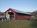 | Bridge, is a wooden covered bridge that carries Murphy Road across the Walloomsac River northwest of Bennington, Vermont. Built in 1889, it was listed on the... 5 KB (371 words) - 03:34, 14 October 2023 |
into the Walloomsac River, the Hoosic River, and the Hudson. The west side drains into White Creek, thence into Owl Kill, the Hoosic River, and the Hudson... 2 KB (155 words) - 02:13, 30 December 2021 |
 | Kill, a tributary of the Shawangunk Kill and by extension the Wallkill River. "Minnewaska State Park Preserve: Sam's Point Area". New York State Parks... 2 KB (92 words) - 04:18, 17 December 2023 |
 | Vermont that have been removed as physical impediments to free-flowing rivers or streams. Map all coordinates using OpenStreetMap Download coordinates... 17 KB (188 words) - 02:31, 12 February 2024 |
 | and begins to parallel the Walloomsac River as the river and highway enter the Green Mountains. VT 9 continues along the river into the town of Woodford... 11 KB (994 words) - 20:45, 18 October 2022 |
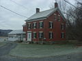
 | located northwest of downtown Bennington, on the eastern bank of the Walloomsac River, bounded by Holden and Leonard Streets to the north and south, and... 4 KB (423 words) - 15:06, 9 February 2022 |