 | Water Remote Sensing is the observation of water bodies such as lakes, oceans, and rivers from a distance in order to describe their color, state of ecosystem... 10 KB (1,143 words) - 05:43, 17 February 2024 |
Remote sensing techniques in archaeology are an increasingly important component of the technical and methodological tool set available in archaeological... 16 KB (2,072 words) - 03:19, 24 November 2023 |
 | Remote sensing is the acquisition of information about an object or phenomenon without making physical contact with the object, in contrast to in situ... 62 KB (7,676 words) - 12:12, 25 April 2024 |
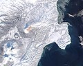
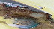 | Remote sensing is used in the geological sciences as a data acquisition method complementary to field observation, because it allows mapping of geological... 58 KB (6,685 words) - 15:33, 12 April 2024 |
India's remote sensing program was developed with the idea of applying space technologies for the benefit of humankind and the development of the country... 12 KB (910 words) - 22:03, 10 April 2024 |
Water Index (NDWI) may refer to one of at least two remote sensing-derived indexes related to liquid water: One is used to monitor changes in water content... 8 KB (1,263 words) - 14:43, 13 June 2023 |
The Indian Institute of Remote Sensing is an institute for research, higher education and training in the field of remote sensing, geoinformatics and GPS... 7 KB (692 words) - 09:17, 9 December 2023 |
 | Thermal remote sensing is a branch of remote sensing in the thermal infrared region of the electromagnetic spectrum. Thermal radiation from ground objects... 13 KB (1,272 words) - 14:24, 19 February 2024 |
 | Ocean color (category Water) brown or red in some cases. This field of study developed alongside water remote sensing, so it is focused mainly on how color is measured by instruments... 41 KB (4,274 words) - 12:29, 2 March 2024 |
Remote sensing in oceanography is a widely used observational technique which enables researchers to acquire data of a location without physically measuring... 33 KB (4,474 words) - 01:32, 30 April 2024 |
 | The Bangladesh Space Research and Remote Sensing Organization (Bengali: বাংলাদেশ মহাকাশ গবেষণা ও দূর অনুধাবন প্রতিষ্ঠান, romanized: Bangladesh mohakash... 5 KB (442 words) - 09:46, 14 April 2024 |
Society for Photogrammetry and Remote Sensing (ASPRS) is an American learned society devoted to photogrammetry and remote sensing. It is the United States'... 6 KB (467 words) - 10:48, 6 November 2023 |
Collocation is a procedure used in remote sensing to match measurements from two or more different instruments. This is done for two main reasons: for... 16 KB (2,105 words) - 23:56, 24 July 2023 |
propagation to navigate, communicate with or detect objects on or under water Remote sensing, acquisition of information about an object or phenomenon without... 1 KB (207 words) - 10:23, 14 September 2021 |
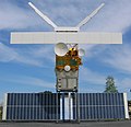 | European Remote Sensing satellite (ERS) was the European Space Agency's first Earth-observing satellite programme using a polar orbit. It consisted of... 9 KB (1,003 words) - 17:39, 22 February 2024 |
SEBAL (category Remote sensing) model which determines water use, primarily in agriculture landscape, using remote sensing-based information "Precious Resources: Water and Landsat's Thermal... 4 KB (451 words) - 22:54, 7 June 2022 |
Flash drought (category Remote sensing) have explored their impacts on agriculture, ecosystems, and water resources. Remote sensing data, such as satellite-derived measurements of soil moisture... 4 KB (355 words) - 08:56, 30 April 2024 |
The Remote Sensing Applications Center (RSAC) is a facility of the United States Forest Service (USFS). It receives weather and fire-monitoring data remotely-sensed... 1 KB (139 words) - 23:39, 27 April 2024 |
 | Ocean optics (category Water) How light acts in water is critical to how ecosystems function underwater. Knowledge of ocean optics is needed in aquatic remote sensing research in order... 29 KB (2,675 words) - 00:00, 16 April 2024 |
 | Vegetation index (category Remote sensing) healthy green vegetation. Since the 1960s scientists have used satellite remote sensing to monitor fluctuation in vegetation at the Earth's surface. Measurements... 16 KB (1,747 words) - 16:39, 27 March 2024 |
 | ground. As remote sensing instruments, they are designed to operate continuously and autonomously often in combination with other atmospheric remote sensors... 20 KB (2,305 words) - 04:23, 25 April 2024 |
 | time scale. These changes increased political interest in gathering remote-sensing data on the Earth itself and stimulated the science of climatology.... 38 KB (1,190 words) - 11:41, 17 April 2024 |
 | Wave radar (category Water waves) description of the most common ground-based radar remote sensing techniques. Instruments based on radar remote sensing techniques have become of particular interest... 16 KB (2,019 words) - 06:31, 22 October 2022 |
 | Evapotranspiration (category Water conservation) Am. Water Resour. Assn. 1996;32:465–473. Bastiaanssen, W. G. M.; Menenti, M.; Feddes, R. A.; Holtslag, A. A. M. (1998-12-01). "A remote sensing surface... 25 KB (3,232 words) - 09:20, 30 April 2024 |
 | Landsat program (redirect from Land remote-sensing satellite) director of the United States Geological Survey, proposed the idea of a remote sensing satellite program to gather facts about the natural resources of our... 41 KB (3,813 words) - 21:11, 5 January 2024 |
 | 2015: Results of the Global WaterPack: a novel product to assess inland water body dynamics on a daily basis. Remote Sensing Letters, Vol. 6, No. 1, 78–87... 15 KB (1,005 words) - 13:00, 30 April 2024 |
 | from Satellite Remote Sensing Data". Remote Sensing. 1 (1): 3–21. Bibcode:2009RemS....1....3L. doi:10.3390/rs1010003. "Remote Sensing of Soil Moisture"... 22 KB (2,926 words) - 08:08, 29 April 2024 |
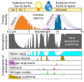 | Atmospheric window (section In remote sensing) sensor) remote sensing techniques work with wavelength ranges contained in the atmospheric windows. Optical window Infrared window Radio window Water window... 9 KB (825 words) - 12:44, 3 January 2024 |
 | Spectroradiometry is a technique in Earth and planetary remote sensing, which makes use of light behaviour, specifically how light energy is reflected... 71 KB (6,330 words) - 17:10, 9 March 2024 |
 | Atmospheric physics (section Remote sensing) Remote sensing is the small or large-scale acquisition of information of an object or phenomenon, by the use of either recording or real-time sensing... 16 KB (1,848 words) - 07:10, 7 April 2024 |