Wedde (Dutch pronunciation: [ˈʋɛdə]) is a village in the municipality Westerwolde in the province Groningen in the Netherlands. It is located 9 km southeast...
7 KB (487 words) - 20:57, 26 February 2022
new municipality of Westerwolde on 1 January 2018. The municipality continues to use both municipal halls in Sellingen and Wedde. The municipality is...
11 KB (383 words) - 17:30, 31 January 2023

Onstwedde, Sellingen, Ter Apel, Vlagtwedde, Vriescheloo, and Wedde. The people in Westerwolde speak Dutch and the West Low German dialect Westerwolds. Historically...
3 KB (106 words) - 23:16, 7 April 2021

Bellingwedde (category Westerwolde (municipality))
Bellingwedde and Vlagtwedde had merged into Westerwolde. The name Bellingwedde is a portmanteau of Bellingwolde and Wedde, which are the names of the two municipalities...
27 KB (1,891 words) - 07:29, 23 February 2024
Blijham (category Westerwolde (municipality))
[blɛiˈɦɑm]) is a village with a population of 2,240 in the municipality of Westerwolde in the province of Groningen in the Netherlands. The origins of the settlement...
10 KB (731 words) - 19:42, 26 February 2024

Bellingwolde (category Westerwolde (municipality))
municipality Westerwolde in the Netherlands. It is situated in the southeast of the region Oldambt, in the north of the region Westerwolde, and in the...
16 KB (1,347 words) - 15:58, 3 October 2023
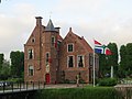
Wedderborg (category Westerwolde (municipality))
the court of Westerwolde until 1818. In 1828, the borg became privately owned. The Wedderborg is located at the Hoofdweg in the village Wedde in the municipality...
11 KB (998 words) - 15:45, 28 March 2023

Veelerveen (category Westerwolde (municipality))
the municipality of Westerwolde in the Netherlands. In 1968, Veelerveen became part of Bellingwedde. And in 2018, part of Westerwolde. Veelerveen is located...
5 KB (314 words) - 18:55, 9 April 2022
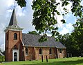
37466 13th century plastered since 20th century ↑ Wedde, Westerwolde Reformed church Kerk van Wedde(NL) RCE 8928 th century ↓ Winschoten Marktpleinkerk...
247 KB (745 words) - 18:45, 21 May 2023
Immediate Media Company. Retrieved 1 August 2015. "Result Stage 1 : Westerwolde, Wedde - Ter Apel" (PDF). Energiewacht Tour. 9 April 2015. Archived from...
31 KB (824 words) - 20:56, 25 January 2024
part around Roermond was left for the Austrian duchy of Guelders. Westerwolde and Wedde: what is now the southeastern part of the province of Groningen...
6 KB (672 words) - 12:23, 7 July 2023

Provincial road N973 (Netherlands) (category Westerwolde (municipality))
provincial road in the municipality of Westerwolde in the province of Groningen in the Netherlands. It runs from Wedde to Bellingwolde. The provincial road...
2 KB (95 words) - 23:56, 11 April 2024

Coat of arms of Bellingwedde (category Westerwolde (municipality))
15 August 2015. (in Dutch) Wedde, Heraldry of the World. Retrieved 15 August 2015. Media related to Symbols of Westerwolde (municipality) at Wikimedia...
3 KB (347 words) - 18:53, 4 December 2020

Duchy of Guelders Gheldria With the Lordship of Drenthe, Lingen, Wedde, and Westerwolde. Since 1543. Territory integrated into the United Provinces in 1581;...
21 KB (1,634 words) - 08:07, 27 February 2024

Wedderveer (category Westerwolde (municipality))
(Dutch pronunciation: [ˌʋɛdərˈveːr]) is a hamlet near Wedde in the municipality of Westerwolde in the Netherlands. It has a population of around 135 and...
4 KB (86 words) - 21:04, 9 April 2022

the Dutch–German border. It is situated in the north of the region of Westerwolde. The building was established in 1643. One side of the building has a...
8 KB (535 words) - 17:23, 5 April 2022

Provincial road N368 (Netherlands) (category Westerwolde (municipality))
8 mi) long. It starts in Blijham in the municipality of Westerwolde, it runs south via Wedde in the same municipality, and ends in Vlagtwedde also in...
2 KB (93 words) - 23:55, 11 April 2024

Spinnenkop Wedderveer (category Westerwolde (municipality))
Spinnenkop Wedderveer Origin Mill location Near the road from Blijham to Wedde Coordinates 53°05′03″N 7°04′06″E / 53.084056°N 7.068366°E / 53.084056;...
4 KB (328 words) - 19:18, 7 March 2023