 | Duluth, but extending into the valleys of the Ush-kab-wan River, Whiteface River, and Cloquet River, for which it is named. The city of Cloquet is located... 5 KB (506 words) - 11:07, 2 October 2022 |
 | Saco River, which reaches the Gulf of Maine at Saco, Maine. The south side of Whiteface is drained by the Whiteface River, thence into the Cold River, Bearcamp... 6 KB (489 words) - 15:41, 2 November 2023 |
 | The Whiteface River is a 5.9-mile-long (9.5 km) river rising in the White Mountains of New Hampshire in the United States. Its waters flow by way of the... 4 KB (184 words) - 13:02, 31 March 2024 |
 | Adirondack Park (redirect from Adirondack State Forest Preserve) wilderness area. Intensive Use: <1%. Places like state campgrounds or day use areas. The developed ski area Whiteface Mountain is in this classification. Historic:... 54 KB (5,823 words) - 14:50, 11 April 2024 |
 | Whiteface River is a 1.9-mile-long (3.1 km) stream in the White Mountains of New Hampshire in the United States. It is a tributary of the Whiteface River... 3 KB (112 words) - 13:49, 4 August 2023 |
 | yellow box, Blakely's red gum, river red gum, bulloak and river she-oak. Native plant species recorded within the state forest include nardoo, rock fern,... 7 KB (441 words) - 20:01, 31 December 2023 |
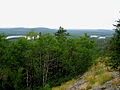
Road). Whiteface is located within the Cloquet Valley State Forest of Saint Louis County. The Whiteface River flows through the community. "Whiteface, Minnesota"... 3 KB (89 words) - 05:40, 30 July 2023 |
 | or 0.98%, is water. The Whiteface River flows through the western portion of the township. The Whiteface River State Forest is located within Meadowlands... 7 KB (575 words) - 06:29, 10 September 2023 |
 | Forest Preserve, comprises almost all the lands owned by the state of New York within the Adirondack and Catskill parks. It is managed by the state Department... 27 KB (3,793 words) - 06:40, 16 April 2024 |
 | Minnesota (redirect from Gopher State) fresh water covering at least ten acres each; roughly a third of the state is forested; much of the remainder is prairie and farmland. More than 60% of Minnesotans... 165 KB (14,582 words) - 02:01, 18 April 2024 |
 | Forestville Mystery Cave State Park is a state park in Minnesota. It contains the village of Forestville, which has been restored to a 19th-century appearance... 6 KB (481 words) - 00:48, 5 March 2024 |
Forest. The river flows generally east and then southeast, leaving the national forest, passing New Hampshire Route 113A in the village of Whiteface,... 3 KB (134 words) - 14:41, 2 February 2021 |
The Rum River State Forest is a state forest located in Kanabec, Mille Lacs and Morrison counties in central Minnesota. The forest is nearby the city of... 4 KB (318 words) - 01:07, 23 June 2022 |
The Lost River State Forest is a state forest located in Roseau County, Minnesota. The forest borders the Canadian province of Manitoba to the north, and... 3 KB (169 words) - 10:18, 10 April 2023 |
 | northern forests. The dome electrolier (chandelier) is lit every Statehood Day on May 11, commemorating when Minnesota became the 32nd state in the union... 45 KB (5,021 words) - 19:52, 19 April 2024 |
 | Program Spurs Work in State Forest Parks". Star Tribune. p. 28. Retrieved January 9, 2021. G. M., Schwartz. "The Geology of Gooseberry State Park" (PDF). Geological... 6 KB (470 words) - 22:16, 1 August 2023 |
 | Superior National Forest, part of the United States National Forest system, is located in the Arrowhead Region of the state of Minnesota between the Canada–United... 12 KB (1,196 words) - 17:37, 17 September 2023 |
 | administered by the state auditor, who had many other duties. Itasca State Park, meanwhile, was being administered as a state forest. In 1923, state auditor Ray... 90 KB (2,841 words) - 09:47, 14 April 2024 |
(east) Whiteface Reservoir Unorganized Territory (southwest) Linwood Lake Unorganized Territory (west and northwest) The Superior National Forest is also... 7 KB (532 words) - 21:56, 21 July 2023 |
The Hill River State Forest is a state forest located in Aitkin County, Minnesota. It borders the Savanna State Forest to the east, and the Chippewa National... 3 KB (205 words) - 20:07, 16 March 2022 |
Cloquet River and the Saint Louis River, it is part of the watershed of Lake Superior. It flows through Whiteface Reservoir Unorganized Territory and... 4 KB (189 words) - 16:05, 15 January 2022 |
 | Long Path (redirect from Long Path through Mine Kill State Park) west or along the Chateaugay River to the north. Curiously, Schaefer's account in Torrey's column never mentions Whiteface as a possible ending point.... 38 KB (5,498 words) - 17:29, 13 September 2023 |
The South Branch of the Whiteface River flows through the southwest part of the township. The North Branch of the Whiteface River flows through the northwest... 7 KB (614 words) - 01:24, 10 September 2023 |
 | Great River Bluffs State Park is a state park of Minnesota, United States, on the Mississippi River southeast of Winona. Originally known as O. L. Kipp... 9 KB (909 words) - 22:16, 1 August 2023 |
Wilmington-Franklin Falls road, the Whiteface Mountain Memorial Highway and the west branch of the Ausable River form the eastern boundary; the Saranac... 4 KB (414 words) - 17:40, 26 March 2023 |
 | The Lake Vermilion-Soudan Underground Mine State Park is a Minnesota state park at the site of the Soudan Underground Mine, on the south shore of Lake... 15 KB (1,293 words) - 18:43, 10 January 2024 |
borders the Superior National Forest and the Boundary Waters Canoe Area Wilderness to the east, the Sturgeon River State Forest to the south, the Nett Lake... 4 KB (268 words) - 20:15, 16 March 2022 |
 | ranger district offices in Blackduck, Deer River and Walker. The Forest was established as the Minnesota Forest Reserve on 27 June 1902, with passage of... 10 KB (1,007 words) - 20:39, 25 March 2024 |
 | Exmoor (redirect from Exmoor Forest) grasses and heather. Traditional breeds include Exmoor Horn, Cheviot and Whiteface Dartmoor and Greyface Dartmoor sheep. North Devon cattle are also farmed... 78 KB (7,470 words) - 19:29, 6 March 2024 |
(179 km2) is land and 2.7 square miles (7.0 km2), or 3.79%, is water. The Whiteface River flows through the township. The following are adjacent to Cotton Township :... 8 KB (596 words) - 00:39, 10 September 2023 |