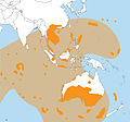
Wilkes Land crater is an informal term that may apply to two separate cases of conjectured giant impact craters hidden beneath the ice cap of Wilkes Land... 13 KB (1,399 words) - 05:33, 16 April 2024 |
 | satellites to discover the 300-mile-wide Wilkes Land crater, which probably formed about 250 million years ago. Wilkes Land is featured prominently in the 1998... 5 KB (438 words) - 23:25, 10 June 2023 |
 | suggested. Another possible cause may be the impact that formed the Wilkes Land crater in Antarctica, which is estimated to have occurred around the same... 22 KB (2,618 words) - 09:22, 13 February 2024 |
 | Australasian strewnfield (section Source crater) Southeast Asia include the Wilkes Land crater in Antarctica, the Zhamanshin crater in Kazakhstan, and the Elgygytgyn crater in Siberia. It has been proposed... 15 KB (1,800 words) - 22:24, 7 May 2024 |
 | History of Earth (section Colonization of land) level fluctuations, and a major anoxic event. Either the proposed Wilkes Land crater in Antarctica or Bedout structure off the northwest coast of Australia... 150 KB (16,266 words) - 09:59, 19 February 2024 |
 | Potts used GRACE data to discover the 480-kilometer-wide (300 mi) Wilkes Land crater in Antarctica, which was probably formed about 250 million years ago... 40 KB (3,442 words) - 13:46, 29 April 2024 |
 | T.; Kim, H. (2009). "GRACE gravity evidence for an impact basin in Wilkes Land, Antarctica". Geochemistry, Geophysics, Geosystems. 10 (2): n/a. Bibcode:2009GGG... 21 KB (1,664 words) - 11:20, 4 January 2024 |
magnetic anomalies Bangui and Jackpine Creek, the gravity anomalies Wilkes Land crater and Falkland Islands, and others have been considered as being of... 130 KB (10,037 words) - 00:20, 7 April 2024 |
| (300 mi) Wilkes Land crater of East Antarctica. An impact has not been proved in either case, and the idea has been widely criticized. The Wilkes Land geophysical... 346 KB (37,474 words) - 15:05, 13 May 2024 |
tectonics. Another possible cause may be the impact that formed the Wilkes Land crater, which may have been contemporaneous and would have been antipodal... 36 KB (3,225 words) - 12:45, 2 April 2024 |
Smith (redirect from Smith (crater)) Ellsworth Land Smith Cliff, Ellsworth Land Smith Glacier, Marie Byrd Land Smith Heights, Oates Land Smith Islands, Wilkes Land Smith Knob, Ellsworth Land Smith... 4 KB (457 words) - 08:53, 13 May 2024 |
Weiss Amphitheater, a caldera in Marie Byrd Land, Antarctica Weiss Hall, a dormitory of Wilkes University, Wilkes-Barre, Pennsylvania, on the National Register... 1 KB (207 words) - 07:07, 28 July 2023 |
 | Mount Erebus (redirect from Side Crater) around 1.3 million years and has a long-lived lava lake in its inner summit crater that has been present since at least the early 1970s. On 28 November, 1979... 39 KB (5,584 words) - 08:46, 29 April 2024 |
a lake in Aveyron Maury Bay, Wilkes Land Maury Glacier, Palmer Land Maury Channel, Nunavut Maury (crater), a small crater on the Moon 3780 Maury, an asteroid... 1 KB (171 words) - 13:52, 6 October 2021 |
Henry (redirect from Henry (crater)) Henry (Obotrite prince) (died 1127), "King of the Slavs" Henry Bay, Wilkes Land Henry River (New South Wales), a tributary of the Mann River Henry River... 6 KB (760 words) - 12:50, 12 May 2024 |
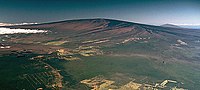 | Mauna Loa (redirect from Wilkes Campsite) Charles Wilkes (1849). Narrative of the United States Exploring Expedition. Vol. IV. G. P. Putnam. pp. 111–162. Russell A. Apple (1973). "Wilkes Campsite... 93 KB (9,938 words) - 23:11, 25 April 2024 |
 | Wilkes named the island's highest point Mount Erie. When Henry Kellett reorganized the official British Admiralty charts in 1847, he removed Wilkes'... 6 KB (623 words) - 22:24, 10 April 2024 |
inventor and entrepreneur Cape Morse, Wilkes Land Mount Morse, Churchill Mountains Morse Nunataks Morse Spur, Victoria Land Rural Municipality of Morse No.... 3 KB (379 words) - 14:20, 18 April 2024 |
 | Trail Kīlauea Crater Puna-Kāʻu Historic District Volcano House Whitney Seismograph Vault No. 29 at the Hawaiian Volcano Observatory Wilkes Campsite The... 32 KB (2,983 words) - 17:36, 21 April 2024 |
 | Hut Point Peninsula (redirect from Sheppard Crater) relation to First Crater and Crater Hill, but the name has fallen into disuse. Twin Crater, alluding to the nested cones in the crater, was applied as early... 16 KB (2,687 words) - 15:34, 24 February 2024 |
 | Frazier Islands (category Islands of Wilkes Land) Interior. Retrieved 2012-04-06. "Frazier Islands, Windmill Islands, Wilkes Land, East Antarctica" (PDF). Management Plan for Antarctic Specially Protected... 3 KB (214 words) - 23:36, 3 July 2021 |
 | (60–400 m) deep. Rift lakes Landslide and ice dam lakes Salt lakes Oxbow lakes Crater lakes Glacial lakes Subglacial lakes Ancient lake formation is similar to... 11 KB (970 words) - 07:20, 2 April 2024 |
 | Molokini (redirect from Molokini Crater) Molokini is a crescent-shaped, partially submerged volcanic crater which forms a small, uninhabited islet located in ʻAlalākeiki Channel between the islands... 11 KB (1,107 words) - 19:04, 21 April 2024 |
 | homosexuality, in 1950s Australia. 2015 saw Berry star as Brian Cleaver in The Crater: A True Story of Vietnam. The film revolves around the experiences of Cleaver... 12 KB (711 words) - 16:35, 13 May 2024 |
 | Bailey Peninsula (category Peninsulas of Wilkes Land) (1 mi) wide, on the Budd Coast of Wilkes Land in Antarctica. It is the site of Australia’s Casey Station. An area of land on the peninsula, lying only some... 2 KB (188 words) - 14:15, 1 February 2024 |
 | Cenote (section Chicxulub crater) alignment of cenotes overlies the measured rim of the Chicxulub crater. This crater structure, identified from the alignment of cenotes, but also subsequently... 25 KB (2,667 words) - 16:56, 27 April 2024 |
 | East Antarctica comprises Coats Land, Queen Maud Land, Enderby Land, Mac. Robertson Land, Wilkes Land, and Victoria Land. All but a small portion of the... 138 KB (14,955 words) - 13:50, 22 April 2024 |
 | southeast flank at 2000 feet of elevation and reached Mokuaweoweo, the summit crater, at 13,200 feet (4,000 m). It was sometimes called Menzies Trail after Archibald... 7 KB (733 words) - 06:49, 9 October 2022 |
Cape Geology (redirect from Botany Bay (Victoria Land)) western limit of Botany Bay, in the southern part of Granite Harbour, Victoria Land, Antarctica. It was charted and named by the Western Geological Party of... 3 KB (374 words) - 18:37, 9 April 2023 |
 | Shackleton went into McMurdo Sound in 1908, having failed to land on King Edward VII Land, he decided to build a hut at Cape Royds, a small promontory... 12 KB (1,875 words) - 13:08, 29 March 2024 |