 | Williamsbridge is a neighborhood geographically located in the north-central portion of the Bronx in New York City. Its boundaries, starting from the... 23 KB (2,356 words) - 10:30, 15 March 2024 |
 | location simply as "Gun Hill Road" (a nearby thoroughfare) rather than "Williamsbridge". Other neighborhood names have greater popularity. For example, Riverdale... 8 KB (884 words) - 15:35, 29 April 2024 |
 | estimated 22% of Woodlawn Heights and Williamsbridge residents lived in poverty, compared to 25% in all of the Bronx and 20% in all of New York City. One... 25 KB (2,467 words) - 10:31, 15 March 2024 |
an estimated 22% of Baychester and Williamsbridge residents lived in poverty, compared to 25% in all of the Bronx and 20% in all of New York City. One... 20 KB (2,025 words) - 11:10, 24 April 2024 |
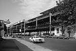
 | Williamsbridge Oval is a park located in Norwood, Bronx, New York City. It is listed in the National Register of Historic Places. The Williamsbridge Oval... 6 KB (364 words) - 19:20, 9 October 2022 |
 | Park (Community District 11); Williamsbridge, Eastchester, Baychester, Edenwald and Wakefield (Community District 12). (Bronx Community District 10) City... 202 KB (21,203 words) - 03:57, 27 April 2024 |
 | Gun Hill Road station (IRT White Plains Road Line) (category Williamsbridge, Bronx) Avenue to East 219th Street–White Plains Road, providing the Bronx communities of Williamsbridge and Wakefield with access to rapid transit service. Service... 11 KB (758 words) - 17:26, 28 April 2024 |
 | Westchester Square, and Williamsbridge. The East Bronx is less densely populated than the West Bronx. While the West Bronx is older and its underlying... 6 KB (631 words) - 02:48, 21 March 2024 |
 | an estimated 22% of Eastchester and Williamsbridge residents lived in poverty, compared to 25% in all of the Bronx and 20% in all of New York City. One... 26 KB (2,682 words) - 10:30, 15 March 2024 |
 | are East Tremont Avenue, Westchester Avenue and Williamsbridge Road. The neighborhood is part of Bronx Community District 10, and its ZIP Codes include... 21 KB (1,935 words) - 20:59, 13 February 2024 |
 | 225th Street station (category Williamsbridge, Bronx) White Plains Road Line of the New York City Subway. Located in Williamsbridge, Bronx, at the intersection of 225th Street and White Plains Road, it is... 9 KB (776 words) - 15:38, 28 April 2024 |
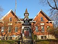
 | White Plains Road at 215th Street in Williamsbridge, Bronx, New York City, New York. The church served the Williamsbridge area along with a parish school on... 5 KB (533 words) - 14:22, 12 October 2023 |
 | Evander Childs Educational Campus (category Williamsbridge, Bronx) campus: Bronx Academy of Health Careers (X290) Bronx Aerospace High School (X545) Bronx High School for Writing and Communication Arts (X253) Bronx Lab School... 6 KB (585 words) - 15:51, 25 March 2024 |
 | Williamsbridge Road and Morris Park Avenue are the primary thoroughfares. The neighborhood is part of Bronx Community District 11 in the East Bronx,... 39 KB (4,070 words) - 02:16, 17 April 2024 |
 | Williamsbridge Reservoir was a natural lake (despite its name) measuring 13.1 acres (5.3 ha) just south of Van Cortlandt Park in the Bronx, New York. Specifically... 8 KB (497 words) - 14:39, 4 January 2022 |
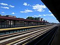 | 233rd Street station (category Williamsbridge, Bronx) Avenue to East 219th Street–White Plains Road, providing the Bronx communities of Williamsbridge and Wakefield with access to rapid transit service. Service... 9 KB (779 words) - 14:36, 22 April 2024 |
 | Richard Manitoba (redirect from Born in the Bronx) neighborhood of Williamsbridge, Bronx, New York City, following his 1954 birth. He spent his last three teenage years living in Co-op City, Bronx, New York... 11 KB (1,084 words) - 19:07, 21 April 2024 |
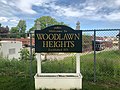
 | Norwood and Williamsbridge (10467) or due to the "Williamsbridge Oval" in Norwood. Irish Americans in New York City Woodlawn Heights, Bronx Woodlawn Cemetery... 37 KB (4,119 words) - 02:42, 28 April 2024 |
 | Williamsbridge Reservoir is a historic home located in the Borough of the Bronx in New York City. It was built in 1889 as part of the Williamsbridge Reservoir... 4 KB (289 words) - 22:30, 19 May 2023 |
geographically located in the East Bronx section of the Bronx, New York City. It is named in honor of Daniel Allerton, an early Bronx settler who purchased and... 25 KB (2,657 words) - 15:57, 15 April 2024 |
 | Burke Avenue station (category Williamsbridge, Bronx) Avenue to East 219th Street–White Plains Road, providing the Bronx communities of Williamsbridge and Wakefield with access to rapid transit service. Service... 10 KB (808 words) - 15:34, 28 April 2024 |
 | Catholic Archdiocese of New York, located at 754 Gun Hill Road, Williamsbridge, Bronx, New York City, New York. The parish was established in 1902–1903... 7 KB (655 words) - 14:52, 9 April 2024 |
Dodge House William Sloane House William Street (Manhattan) Williamsbridge, Bronx Williamsbridge Oval Williamsburg, Brooklyn Willowbrook, Staten Island Windsor... 45 KB (5,440 words) - 12:05, 14 January 2024 |
 | Street–Williamsbridge station, signed as Williamsbridge–210th Street, was the penultimate station on the demolished IRT Third Avenue Line in the Bronx, New... 4 KB (287 words) - 14:58, 3 November 2023 |
 | September 10, 2018. Retrieved March 14, 2019. "Wakefield-Williamsbridge, New York City-Bronx, New York Zip Code Boundary Map (NY)". United States Zip... 23 KB (2,147 words) - 23:27, 7 April 2024 |
The West Bronx is a region in the New York City borough of the Bronx. The region lies west of the Bronx River and roughly corresponds to the western half... 5 KB (591 words) - 19:29, 12 June 2023 |
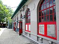
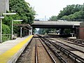 | Williams Bridge station (redirect from Williamsbridge (NYC station)) the Metro-North Railroad's Harlem Line, serving the Williamsbridge and Norwood sections of the Bronx, New York City. The station is located at the intersection... 7 KB (581 words) - 02:38, 14 March 2024 |
 | Avenue–138th Street station (via Morris-Jerome Avenues) Bx41 and Bx41 SBS: to Williamsbridge, Gun Hill Road (via Webster Avenue) M125: to Manhattanville (via 125th... 11 KB (1,001 words) - 16:38, 31 January 2024 |
Killing of Ramarley Graham (category Williamsbridge, Bronx) The killing of Ramarley Graham took place in the borough of the Bronx in New York City on February 2, 2012. Richard Haste, a New York Police Department... 11 KB (1,049 words) - 21:41, 19 December 2023 |
 | neighborhood in the southwestern section of the New York City borough of the Bronx. It adjoins the business and one-time theater area known as The Hub. Melrose... 28 KB (2,951 words) - 06:44, 15 January 2024 |