flows into the East Fork and eventually into the Yukon River. Wind River is a National Wild and Scenic River. The main stem, headwaters, and an unnamed tributary—140... 4 KB (154 words) - 05:58, 6 January 2023 |
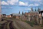 | Fort Yukon (Gwichyaa Zheh in Gwich'in) is a city in the Yukon-Koyukuk Census Area in the U.S. state of Alaska, straddling the Arctic Circle. The population... 25 KB (1,645 words) - 20:11, 18 April 2024 |
 | 000 sq mi) lies in Canada. The total area is more than 25% larger than Texas or Alberta. The longest river in Alaska and Yukon, it was one of the principal means... 46 KB (3,662 words) - 12:53, 21 April 2024 |
Wind River may refer to: Wind River (Yukon) Wind River (Yukon–Koyukuk Census Area, Alaska), a designated National Wild and Scenic River Wind River (Colorado)... 975 bytes (147 words) - 06:02, 17 December 2023 |
 | city in the Yukon-Koyukuk Census Area of the Unorganized Borough of the U.S. state of Alaska. The population was 105 at the 2010 census. Several Native... 20 KB (1,668 words) - 15:22, 18 April 2024 |
 | The Fortymile River is a 60-mile (97 km) tributary of the Yukon River in the U.S. state of Alaska and the Canadian territory of Yukon. Beginning at the... 9 KB (672 words) - 15:07, 26 April 2024 |
 | Picea mariana. The river forms part of the boundary between the Southeast Fairbanks and Yukon–Koyukuk census areas. The Charley River is generally floated... 6 KB (382 words) - 05:45, 6 January 2023 |
 | Taatthee Niign) is a 180-mile (290 km) tributary of the Yukon River in the U.S. state of Alaska. The creek begins at the confluence of Champion and Bear... 9 KB (749 words) - 06:01, 6 January 2023 |
 | The Koyukuk National Wildlife Refuge is a 3,500,000-acre (14,000 km2) conservation area in Alaska. It lies within the floodplain of the Koyukuk River, in... 4 KB (430 words) - 20:18, 30 June 2022 |
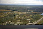
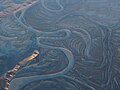
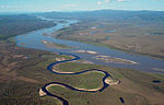
 | The Yukon Flats National Wildlife Refuge is a protected wetland area in the U.S. state of Alaska. It encompasses most of the Yukon Flats, a vast wetland... 5 KB (385 words) - 03:34, 14 January 2023 |
 | The Alaska Railroad continued to operate the remaining TVRR narrow gauge line as the Chatanika Branch (the terminus was located near the Yukon River), until... 44 KB (4,346 words) - 19:31, 16 April 2024 |
 | Wood River (Nushagak River tributary) Wulik River Yahtse River Yentna River Yetna River Yuki River Yukon River Zitiana River List of islands of Alaska List... 38 KB (3,512 words) - 19:36, 16 November 2023 |
 | North Fork of the Koyukuk River is one of the principal forks of the Koyukuk River, approximately 105 mi (160 km) long, in northern Alaska in the United States... 4 KB (225 words) - 03:16, 7 February 2024 |
 | The John River (Iñupiaq: Atchiiniq) is a 125-mile (201 km) tributary of the Koyukuk River in the northern part of the U.S. state of Alaska. It was named... 8 KB (528 words) - 15:36, 21 January 2024 |
 | extending to the Bering Sea, covering the delta created by the Yukon and Kuskokwim rivers. The delta includes extensive wetlands near sea level that are... 5 KB (450 words) - 14:01, 24 December 2023 |
 | enters the larger river at Fort Yukon, Alaska. It derives its name from the Gwich'in word for the river, Ch'oonjik, or "Porcupine Quill River". The Porcupine... 6 KB (474 words) - 23:17, 16 January 2022 |
 | The Nowitna River is a 250-mile (400 km) tributary of the Yukon River in the U.S. state of Alaska. The river flows northeast from the Kuskokwim Mountains... 6 KB (400 words) - 05:42, 6 January 2023 |
 | The Tinayguk River is a 44-mile (71 km) tributary of the North Fork Koyukuk River in the U.S. state of Alaska. Heading in the Endicott Mountains of the... 6 KB (369 words) - 08:46, 23 February 2022 |
 | Elliott Highway (redirect from Elliott Highway (Alaska)) at the Yukon River. The last 12 miles is private property, and belongs to the village corporation Tozitna Limited. The parking lot by the river is for... 6 KB (563 words) - 00:35, 11 May 2023 |
 | and the only habitable area of Little Diomede Island in the Nome Census Area of the Unorganized Borough of the U.S. state of Alaska. All the buildings are... 41 KB (4,506 words) - 20:22, 18 April 2024 |
 | Birch Creek is a 150-mile (240 km) tributary of the Yukon River in the U.S. state of Alaska. Beginning at the confluence of Ptarmigan and Eagle creeks... 10 KB (814 words) - 15:44, 23 December 2023 |
 | Arctic National Wildlife Refuge (category Protected areas of Yukon–Koyukuk Census Area, Alaska) which conserves the wildlife of Alaska. In 1929, a 28-year-old forester named Bob Marshall visited the upper Koyukuk River and the central Brooks Range on... 41 KB (4,751 words) - 16:54, 20 March 2024 |
 | Yukon–Charley Rivers National Preserve is a United States national preserve located in east central Alaska along the border with Canada. Managed by the... 17 KB (2,118 words) - 19:29, 19 May 2022 |
 | Mount Doonerak (category Landforms of Yukon–Koyukuk Census Area, Alaska) most popular climbing areas in the park. Precipitation runoff from the mountain drains north into the North Fork Koyukuk River. Topographic relief is... 6 KB (519 words) - 19:05, 8 March 2024 |
 | Dillon Mountain (category Landforms of Yukon–Koyukuk Census Area, Alaska) Dietrich Rivers merge to form Middle Fork Koyukuk River. Sukakpak Mountain rises 3 mi (5 km) to the southwest, and Dietrich Camp of the Trans-Alaska Pipeline... 4 KB (323 words) - 00:14, 23 December 2023 |
 | north-northwest of Fairbanks, where the Bettles and Dietrich Rivers merge to form Middle Fork Koyukuk River. The peak's Sukakpak name was reported in 1930 by the... 5 KB (344 words) - 05:52, 11 February 2024 |
 | The Unalakleet River (Iñupiaq: Uŋalaqłiit Kurgat) in the U.S. state of Alaska flows southwest 90 miles (145 km) from the Kaltag Mountains to near the town... 7 KB (460 words) - 19:02, 12 June 2023 |
the Yukon and the coast and are occupied almost exclusively with buying up furs from the natives living along the Yunnaka (Koyukuk River, a Yukon tributary)... 442 KB (33,705 words) - 16:31, 26 April 2024 |
 | last section of the river continues to flow in a SSE direction through the Alatna Hills into its confluence with the Koyukuk River near the small village... 6 KB (478 words) - 16:06, 31 October 2021 |
 | Alaska, United States. The population was 282 at the 2000 census and 324 as of the 2010 census. Anaktuvuk Pass was named after the Anaktuvuk River. Anaktuvuk... 23 KB (1,847 words) - 15:22, 18 April 2024 |