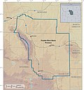
 | The Wyodak mine is a coal mine in Wyodak, Wyoming, United States, located about 6 miles (9.7 km) east of Gillette in the coal-rich Powder River Basin.... 6 KB (481 words) - 22:15, 5 January 2020 |
 | Black Hills Corporation (redirect from Wyodak Resources Development) the Wyodak Mine near Gillette, Wyoming in the Powder River Basin, which is the oldest operating surface mine for coal in the United States. The mine has... 13 KB (1,275 words) - 05:26, 15 April 2024 |
 | the original on 2009-04-17. Retrieved 2009-04-21. "Wyodak Resources Development Home Page". Wyodak website. Black Hills Corporation. Retrieved 2009-04-21... 10 KB (336 words) - 00:54, 9 May 2023 |
 | 1960s the company planned to mine the area and the houses were gradually moved. The following highways pass through Wyodak: I-90 (Interstate 90) US 14... 4 KB (105 words) - 06:09, 27 July 2023 |
 | Development (Wyodak Mine) Contura Energy (Belle Ayr Mine, Eagle Butte Mine) Navajo Transitional Energy Company (Antelope Mine, Cordero Rojo Mine) Kiewit Corporation... 29 KB (3,329 words) - 07:58, 19 October 2023 |
Union-Wasatch Formation. The Roland coalbed, which was being surface mined at the Wyodak Mine 25 miles (40 km) to the east, lies at depths of 1,000 feet (300 m)... 7 KB (870 words) - 20:30, 13 March 2024 |
2019-09-10. Retrieved 2020-06-07. "Wyodak Power Plant". Global Energy Monitor. Retrieved 2021-05-08. "Wyodak Mine". Global Energy Monitor. Retrieved 2021-05-08... 29 KB (1,144 words) - 03:47, 8 September 2023 |
 | Archived (PDF) from the original on 2012-02-12. Retrieved 2009-02-15. "Wyodak Coal, Tongue River Member of the Fort Union Formation, Powder River Basin... 68 KB (9,073 words) - 07:53, 22 April 2024 |
mine producing a low-sulfur, sub-bituminous coal from the Wyodak-Anderson seam that is used for domestic energy generation. Coal produced by the mine... 8 KB (612 words) - 20:42, 8 January 2024 |
 | Paleogene Mining the coal-rich Tongue River Member, Fort Union Formation (Wyodak coal mine, Powder River Basin, Wyoming) Type Member Unit of Fort Union Formation... 2 KB (182 words) - 21:53, 15 March 2024 |
 | Mine and owns the Dave Johnston Mine, which is in final reclamation. The company also owned and operated the Deer Creek Mine in Utah, near the Huntington... 16 KB (1,358 words) - 05:13, 9 November 2023 |
seven West Virginia mines in 1987. Peabody also expanded westward, opening the North Antelope and Rochelle mines in the low sulfur Wyodak seam in the heart... 48 KB (4,610 words) - 13:17, 28 March 2024 |
 | Croton Echeta Pleastantdale Recluse Rozet Savageton Spotted Horse Weston Wyodak Campbell County is overwhelmingly Republican. No Democratic presidential... 16 KB (1,240 words) - 14:59, 26 April 2024 |
 | through the communities of Wyodak and Rozet, south of the Campbell County fairgrounds [1], coal mines, and south of Wyodak power plant. Wyoming 51 is... 5 KB (284 words) - 17:45, 24 June 2023 |
Virgilina Vir-Mar Beach Viropa Lake Wissota (village) Lake Wissota Wyocolo Wyodak Wyuta Alcan Border Canalaska Mountain Map legend: red dot = border portmanteau... 100 KB (9,111 words) - 07:03, 27 March 2024 |
 | 32 coal seams total more than 300 feet in thickness. One such bed, the Wyodak Coal near Gillette, Wyoming, is as much as 110 feet (34 m) thick. Most of... 50 KB (1,554 words) - 06:59, 14 May 2024 |