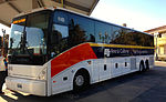
 | The Yosemite Area Regional Transportation System (YARTS) is a public transit bus line based in Merced, California. YARTS provides scheduled fixed route... 9 KB (712 words) - 19:22, 22 January 2024 |
 | connections to Amtrak and Yosemite National Park are available through local bus service and Yosemite Area Regional Transportation System (YARTS). The airport... 17 KB (1,870 words) - 22:15, 18 April 2024 |
 | Amtrak Thruway (category Bus transportation in the United States) Transportation route) Route 15A: Merced – Yosemite (through-ticketed Yosemite Area Regional Transportation System route) Route 15B: Fresno – Yosemite... 19 KB (1,472 words) - 23:30, 20 April 2024 |
 | a transfer point between trains and Yosemite Area Regional Transportation System (YARTS) buses serving Yosemite National Park. Merced station has side... 9 KB (914 words) - 18:38, 11 March 2024 |
 | Ahwahnee Hotel Yosemite Area Regional Transportation System (YARTS) Wikimedia Commons has media related to Yosemite Valley Lodge. "Yosemite Lodge Rooms"... 6 KB (572 words) - 07:09, 19 January 2023 |
is located around five miles north of Merced and sits adjacent to Lake Yosemite. The main campus is around 1,026 acres (415 ha) in size, and total land... 52 KB (4,739 words) - 12:34, 1 April 2024 |
 | Mammoth Lakes, California (category Articles with MusicBrainz area identifiers) Eastern Sierra Transit Authority. Yosemite Area Regional Transportation System provides summer bus connections to Yosemite. Various western films have been... 32 KB (2,955 words) - 12:46, 21 April 2024 |
 | Merced (near Merced) Transportation Merced County Transit Merced Regional Airport Yosemite Area Regional Transportation System Healthcare Mercy Medical... 6 KB (415 words) - 23:15, 1 February 2024 |
Merced County Transit (redirect from Merced Transportation Center) bus service to Sacramento, the Bay Area, and Los Angeles. YARTS and VIA Adventures provide bus service to Yosemite National Park. Situated at the same... 12 KB (679 words) - 05:33, 17 April 2024 |
 | Merced, California (redirect from Gateway to Yosemite) flows nearby. Merced, known as the "Gateway to Yosemite", is less than two hours by automobile from Yosemite National Park to the east and Monterey Bay,... 50 KB (4,373 words) - 10:40, 28 April 2024 |
 | Tuolumne County, California (redirect from Sonora, California micropolitan area) public transportation into or out of Tuolumne County that connects to any of the closest metropolitan areas. Yosemite Area Regional Transportation System (YARTS)... 50 KB (2,127 words) - 15:29, 23 April 2024 |
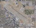 | Fresno Yosemite International Airport (IATA: FAT, ICAO: KFAT, FAA LID: FAT) is a joint military–public airport in Fresno, California, United States. It... 60 KB (4,976 words) - 23:14, 5 April 2024 |
 | Yosemite area includes primarily granitic rocks with some older metamorphic rock. The first rocks were laid down in Precambrian times, when the area around... 18 KB (2,472 words) - 13:18, 25 July 2023 |
Sainyabuli Province, Laos, the Lees, and their interactions with the health care system in Merced, California. In 2005 Robert Entenmann of St. Olaf College wrote... 16 KB (1,785 words) - 00:12, 15 February 2024 |
 | to establish Yosemite Valley and its surrounding areas as a National Park. This helped pave the way for the National Park System. Yosemite draws about... 115 KB (10,841 words) - 08:21, 8 April 2024 |
Merced (near Merced) Transportation Merced County Transit Merced Regional Airport Yosemite Area Regional Transportation System Healthcare Mercy Medical... 9 KB (690 words) - 05:31, 29 November 2023 |
 | Fresno, California (redirect from Fresno, California metropolitan area) provided by Greyhound. The Yosemite Area Regional Transportation System added summer seasonal service between Fresno and Yosemite National Park in May 2015... 99 KB (9,071 words) - 10:30, 28 April 2024 |
Merced (near Merced) Transportation Merced County Transit Merced Regional Airport Yosemite Area Regional Transportation System Healthcare Mercy Medical... 5 KB (417 words) - 22:52, 24 April 2023 |
 | Mammoth Yosemite Airport (IATA: MMH, ICAO: KMMH, FAA LID: MMH) is a town-owned public airport seven miles (11 km; 6.1 nmi) east of Mammoth Lakes, in Mono... 13 KB (1,230 words) - 21:59, 18 April 2024 |
 | Merced County, California (redirect from Merced, CA Metropolitan Statistical Area) operates its own transit system, Cat Tracks. This system connects with Merced County Transit. Yosemite Area Regional Transportation System, or YARTS, connects... 54 KB (2,379 words) - 15:18, 23 April 2024 |
 | Mariposa County, California (category Articles with MusicBrainz area identifiers) fixed route service Yosemite Area Regional Transportation System (YARTS) provides service along State Routes 120 and 140 to Yosemite National Park. Amtrak... 47 KB (2,521 words) - 10:40, 28 April 2024 |
 | about the excessive exploitation of the area. Their efforts helped establish Yosemite National Park in 1890. Yosemite Valley and the Mariposa Grove were added... 78 KB (9,156 words) - 03:03, 10 April 2024 |
 | service to nearby Mammoth Yosemite Airport and also marked the return of scheduled passenger service to Eastern Sierra Regional Airport and Bishop. The... 10 KB (1,000 words) - 04:59, 20 March 2024 |
 | Northern California (category Megapolitan areas of California) Bay Area and Sacramento. The U.S. National Park System controls a large and diverse group of parks in northern California. The best known is Yosemite National... 76 KB (5,568 words) - 22:07, 13 April 2024 |
(Livingston) Merced High School (Merced) Sequoia High School (Merced) Yosemite High School (Merced) The district has its headquarters within the Castle... 6 KB (392 words) - 03:09, 28 May 2022 |
 | Santa Fe Passenger Depot (Fresno, California) (category Transportation in Fresno, California) Coalinga, Orange Cove, Southeast, Westside Greyhound Lines Yosemite Area Regional Transportation System: Highway 41 Route (seasonal, May–September) V-LINE connections... 12 KB (1,012 words) - 00:54, 20 April 2024 |
The intercity transportation system in Visalia serves as a regional hub for passenger and freight traffic in the Sequoia Valley, composed of freeways... 3 KB (208 words) - 04:50, 14 February 2024 |
 | the Modesto Area Express (MAX) and Stanislaus Regional Transit (StaRT) systems. Most routes connect at the downtown Modesto Transportation Center; the... 23 KB (1,068 words) - 02:31, 14 April 2024 |
 | Kern County’s transportation system was quoted as the “unseen industry.” Located at the southern end of the San Joaquin Valley, the county is at a prime... 30 KB (3,538 words) - 00:11, 20 February 2024 |
 | Hetch Hetchy (category Geology of Yosemite National Park) reservoir, and a water system in California in the United States. The glacial Hetch Hetchy Valley lies in the northwestern part of Yosemite National Park and... 62 KB (6,693 words) - 10:32, 28 April 2024 |