
 French
 Deutsch
Datei:China-Heilongjiang.png – Wikipedia
China-Heilongjiang.png (268 × 218 Pixel, Dateigröße: 31 KB, MIME-Typ: image/png)
![]()
Diese Datei und die Informationen unter dem roten Trennstrich werden aus dem zentralen Medienarchiv Wikimedia Commons eingebunden.
![]()
 | File:China Heilongjiang.svg ist eine vektorisierte Version dieses Bildes. Diese sollte an Stelle des Rasterbildes verwendet werden, sofern sie nicht schlechter ist. File:China-Heilongjiang.png → File:China Heilongjiang.svg Für weitere Informationen siehe Help:SVG. |  |
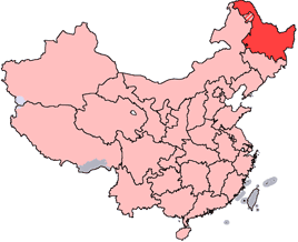
en: Location of Heilongjiang Province in the People's Republic of China. See Locator maps of province-level divisions of the People's Republic of China for more information. The striped area is administered by Daxing'anling Prefecture of Heilongjiang, but it is nominally part of Inner Mongolia Autonomous Region.
zh: 黑龍江省在中華人民共和國的位置。另見Locator maps of province-level divisions of the People's Republic of China。加斜杠的地區由黑龍江省大興安嶺地區所管轄,但在名義上為内蒙古自治區的一部分。
 | Es ist erlaubt, die Datei unter den Bedingungen der GNU-Lizenz für freie Dokumentation, Version 1.2 oder einer späteren Version, veröffentlicht von der Free Software Foundation, zu kopieren, zu verbreiten und/oder zu modifizieren; es gibt keine unveränderlichen Abschnitte, keinen vorderen und keinen hinteren Umschlagtext. Der vollständige Text der Lizenz ist im Kapitel GNU-Lizenz für freie Dokumentation verfügbar. |
| Diese Datei ist unter der Creative-Commons-Lizenz „Namensnennung – Weitergabe unter gleichen Bedingungen 3.0 nicht portiert“ lizenziert. | ||
| ||
| Diese Lizenzmarkierung wurde auf Grund der GFDL-Lizenzaktualisierung hinzugefügt. |
Dateiversionen
Klicke auf einen Zeitpunkt, um diese Version zu laden.
| Version vom | Vorschaubild | Maße | Benutzer | Kommentar | |
|---|---|---|---|---|---|
| aktuell | 16:45, 28. Okt. 2007 | | 268 × 218 (31 KB) | Croquant | transparent background |
| 23:47, 4. Jun. 2005 |  | 268 × 218 (9 KB) | Ran | '''en''': Location of Heilongjiang Province in the People's Republic of China. See Category:Locator maps of province-level divisions of the People's Republic of China for more information. The striped area is administered by Daxing'anling Prefecture |
Dateiverwendung
Die folgenden 15 Seiten verwenden diese Datei:
Globale Dateiverwendung
Die nachfolgenden anderen Wikis verwenden diese Datei:
- Verwendung auf cy.wikipedia.org
- Verwendung auf da.wikipedia.org
- Verwendung auf en.wikipedia.org
- Pingfang, Harbin
- Wikipedia:WikiProject Chinese provinces/Locator maps
- Songjiang Province
- Longjiang County
- Jingpo Lake
- Wanda Mountains
- Mingshui County
- Heitai
- Kedong County
- Bei'an
- Nan'gang, Harbin
- Yabuli Ski Resort
- Ang'angxi District
- Diaoshuilou Falls
- Mudan River
- Zhalong Nature Reserve
- Nenjiang Province
- Gannan County
- Nehe
- Shuangcheng, Harbin
- Tangchi, Heilongjiang
- Tieli
- Mishan
- Baoquan, Heilongjiang
- Heihe Aihui Airport
- Yi'an Town, Heilongjiang
- Laha, Heilongjiang
- Muling
- Template:Heilongjiang-geo-stub
- Daxing'anling Prefecture
- Daoli, Harbin
- HLA-B67
- HLA-B59
- Jiangqiao Mongol Ethnic Town
- Wanjia re-education through labor camp
- Nenjiang City
- Huma River (Heilongjiang)
- Lesser Khingan
- Meilisi Daur District
- Jiagedaqi District
- Nanshan District, Hegang
- Daowai, Harbin
- Xiangfang, Harbin
- Songbei, Harbin
- Hulan District
- Fangzheng County
- Bin County, Heilongjiang
- Bayan County
Weitere globale Verwendungen dieser Datei anschauen.