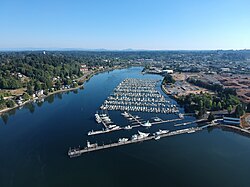
Budd Inlet
| Budd Inlet | |
|---|---|
 View from ISS Expedition 71, June 2024 | |
| Location | Thurston County, Washington |
| Coordinates | 47°5′39″N 122°54′48.7″W / 47.09417°N 122.913528°W |
| Type | Inlet |
| Etymology | Thomas A. Budd |
| Part of | South Puget Sound |
| River sources | Deschutes River |
| Ocean/sea sources | Salish Sea |
| Max. length | 6.84 mi (11.01 km) |
| Max. width | 1.86 mi (2.99 km) |
| Sections/sub-basins | West Bay, East Bay |
| Settlements | Olympia, Washington |
Budd Inlet is an inlet located at the southernmost end of Puget Sound in Thurston County, Washington, surrounded on three sides by the City of Olympia.[1][2]
Etymology
[edit]Budd Inlet was named by Charles Wilkes during the United States Exploring Expedition, to honor Thomas A. Budd, who served as acting master of the Peacock and Vincennes.[3][4] A portion of the coast of Antarctica, Budd Coast, is also named for Thomas Budd.
History
[edit]Historically, the shores surrounding Budd Inlet were occupied by village sites of the Steh-Chass (or Stehchass), Lushootseed-speaking peoples who became part of the post-treaty Squaxin Island Tribe.
Around 1850, American settlers founded the city of Olympia at the southern end of Budd Inlet.[5]
Geography
[edit]Budd Inlet is 6.84 mi (11.01 km) long and has a maximum breadth of 1.86 mi (2.99 km). The southern end of Budd Inlet is divided into two channels – West Bay and East Bay – by a peninsula that was artificially broadened throughout the late 19th and early 20th century. The entrance to Budd Inlet is formed by two peninsulas: Cooper Point, and Boston Harbor, Washington.[6]

The Deschutes River empties into West Bay just north of Tumwater Falls. The mudflats that existed here were dammed and submerged beneath Capitol Lake in 1949.
During c. 1909 – c. 1911, a deepwater shipping channel was dredged in East Bay to provide deep water access to the Port of Olympia, formed on November 7, 1922.[7]
Ecology
[edit]The inlet is contaminated from historical industrial activity (such as sawmills and plywood manufacturing) taking place in the area over the past century.[8] Inlet sediment samples were found to contain dioxins, dioxin-like polychlorinated biphenyls, polycyclic aromatic hydrocarbons, pentachlorophenol, and metals such as mercury, arsenic, cadmium.[9]
On May 15, 2025, as a result of a biotoxin which produces Diarrhetic shellfish poisoning being detected, the inlet was closed to recreational shellfish harvesting.[10]
A significant cleanup and restoration project is currently underway, with construction estimated to begin in 2027.[2]

See also
[edit]References
[edit]- ^ "Deschutes River watershed area: Budd Inlet - Washington State Department of Ecology". ecology.wa.gov. Retrieved 2020-10-01.
- ^ a b "Budd Inlet Cleanup and Restoration". Port of Olympia. Retrieved June 21, 2025.
- ^ Phillips, James W. (1971). Washington State Place Names. University of Washington Press. ISBN 0-295-95158-3.
- ^ Crooks, Drew (2012-12-16). "History Behind The Place Name: Budd Inlet". ThurstonTalk. Retrieved 2025-06-21.
- ^ "History of Olympia, Washington". olympiawa.gov. July 27, 2012. Archived from the original on September 10, 2012. Retrieved September 14, 2012.
- ^ "Google Maps". Google Maps.
- ^ Riddle, Margaret (2011-03-28). "Port of Olympia is formed by public vote on November 7, 1922". www.historylink.org. Retrieved 2025-06-21.
- ^ Branch, Harry (October 15, 2024). "Budd Inlet – You don't know what you've got till it's gone". Works in Progress. 35 (4).
- ^ Smith, Sandy. "Budd Inlet Sediments". Cleanup and Tank Search. Washington State Department of Ecology. Retrieved July 19, 2025.
- ^ "Budd Inlet Closed to Recreational Shellfish Harvesting Due to Biotoxin". Thurston County. May 15, 2025. Retrieved June 21, 2025.
External links
[edit]![]() Media related to Budd Inlet at Wikimedia Commons
Media related to Budd Inlet at Wikimedia Commons


 French
 Deutsch


