
 French
 Deutsch
Chief Joseph Mountain
| Chief Joseph Mountain | |
|---|---|
 Northeast aspect, from Wallowa Lake | |
| Highest point | |
| Elevation | 9,616 ft (2,931 m)[1] |
| Prominence | 776 ft (237 m)[2] |
| Parent peak | Hurwal Divide (9,776 ft)[3] |
| Isolation | 1.83 mi (2.95 km)[3] |
| Coordinates | 45°17′08″N 117°15′42″W / 45.2854779°N 117.2617823°W[4] |
| Naming | |
| Etymology | Chief Joseph |
| Geography | |
 Chief Joseph Mountain Location in Oregon  Chief Joseph Mountain Chief Joseph Mountain (the United States) | |
| Location | Eagle Cap Wilderness |
| Country | United States of America |
| State | Oregon |
| County | Wallowa |
| Parent range | Wallowa Mountains |
| Topo map | USGS Chief Joseph Mountain |
| Geology | |
| Age of rock | Miocene |
| Type of rock | Columbia River basalt |
| Climbing | |
| Easiest route | scrambling[1] |
Chief Joseph Mountain is a 9,616-foot elevation (2,931 m) mountain summit located in Wallowa County, Oregon, US.
Description[edit]
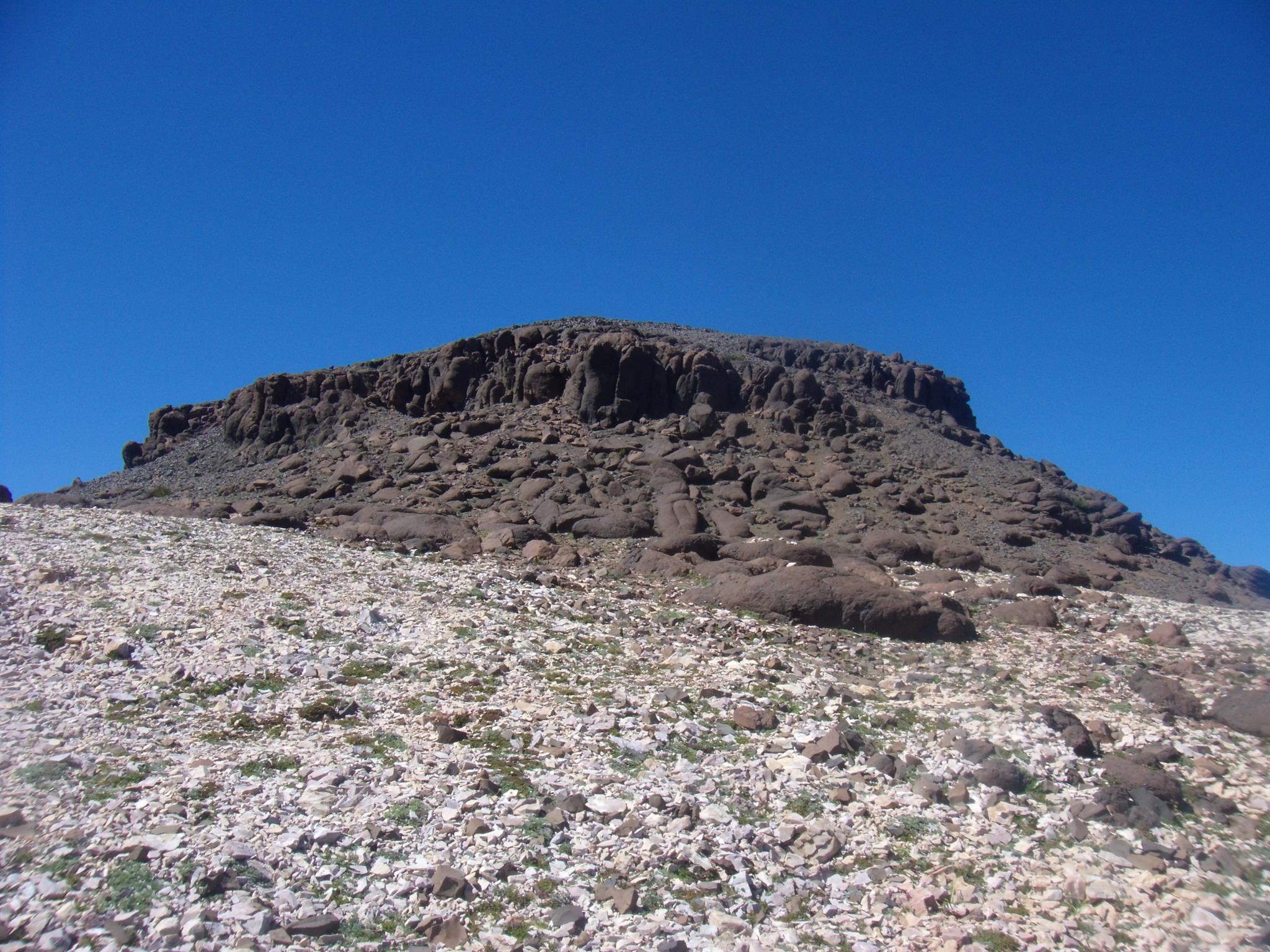
Chief Joseph Mountain is located five miles south of Joseph, Oregon, in the Wallowa Mountains. It is set within the Eagle Cap Wilderness on land managed by Wallowa–Whitman National Forest.[2] The peak ranks as the 14th-highest summit in Oregon,[3] and the 8th-highest of the Wallowa Mountains.[2] The peak is situated southwest of Wallowa Lake and precipitation runoff from the mountain drains into tributaries of the Wallowa River. Topographic relief is significant as the summit rises over 5,200 feet (1,600 meters) above the lake in approximately three miles. The bulk of the mountain is a complex geology of Mesozoic granodiorite of the Wallowa Batholith, limestone, greenstone, and a small relict summit cap composed of Columbia River basalt.[5]
Etymology[edit]

This landform's toponym was officially adopted in 1925 by the United States Board on Geographic Names to honor Chief Joseph (1840–1904), leader of the Wal-lam-wat-kain (Wallowa) band of Nez Perce tribe.[4] Chief Joseph led his band of Nez Perce during the most tumultuous period in their history, when they were forcibly removed by the United States federal government from their ancestral lands in the Wallowa Valley. Ironically, Mount Howard which is immediately across the Wallowa Valley from Chief Joseph Mountain is named after Oliver Otis Howard, the Army officer responsible for evicting Chief Joseph in 1877.[6] "Point Joseph" is an alternate official name for the summit and "Tunnel Mountain" has also been used in the past.[4] The nearby town of Joseph is also named after him.
Climate[edit]
Based on the Köppen climate classification, Chief Joseph Mountain is located in a subarctic climate zone characterized by long, usually very cold winters, and mild summers.[7] Winter temperatures can drop below −10 °F with wind chill factors below −20 °F. Most precipitation in the area is caused by orographic lift.
Gallery[edit]
-
 Northeast aspect
 -
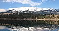 North-northeast aspect of Chief Joseph Mountain reflected in Wallowa Lake
 -
 East-southeast aspect of Chief Joseph Mountain seen from Mount Howard
 -
 Hurwal Divide (left) and Chief Joseph Mountain (right) from Mt. Howard


See also[edit]
References[edit]
- ^ a b Barbara Bond (2005), 75 Scrambles in Oregon, Mountaineers Books, ISBN 9781594852909
- ^ a b c "Chief Joseph Mountain, Oregon". Peakbagger.com. Retrieved October 5, 2022.
- ^ a b c "Chief Joseph Mountain - 9,616' OR". listsofjohn.com. Retrieved October 5, 2022.
- ^ a b c "Chief Joseph Mountain". Geographic Names Information System. United States Geological Survey, United States Department of the Interior. Retrieved October 5, 2022.
- ^ Mineral Resources of the Eagle Cap Wilderness and Adjacent Areas, USGS (1976), p. 45–48
- ^ "Backroads of the Great American West", 2021, Motorbooks, ISBN 9780760369975, p. 151
- ^ Peel, M. C.; Finlayson, B. L.; McMahon, T. A. (2007). "Updated world map of the Köppen−Geiger climate classification". Hydrol. Earth Syst. Sci. 11: 1633–1644. ISSN 1027-5606.
External links[edit]
- Weather forecast: Chief Joseph Mountain
- Basalt summit cap (photo): Peakbagger.com
Places adjacent to Chief Joseph Mountain | ||||||||||||||||
|---|---|---|---|---|---|---|---|---|---|---|---|---|---|---|---|---|
| ||||||||||||||||