
 French
 Deutsch
City of Rocks State Park
| City of Rocks State Park | |
|---|---|
 City of Rocks State Park | |
 Location of City of Rocks State Park in New Mexico | |
| Location | Grant, New Mexico, United States |
| Coordinates | 32°35′24″N 107°58′33″W / 32.59000°N 107.97583°W |
| Area | 1,230 acres (5.0 km2) |
| Elevation | 5,259 ft (1,603 m) |
| Established | 1953 |
| Governing body | New Mexico State Parks Division |
City of Rocks State Park is a state park in New Mexico, consisting of large sculptured rock formations in the shape of pinnacles or boulders rising as high as 40 feet (12 m).
Geology[edit]
The bedrock forming City of Rocks was created 34.9 million years ago by a volcanic eruption. Then over millions of years, erosion sculpted the rock formations seen today.[1] The eruption was from the Emory Caldera, centered near Hillsboro Peak at the southern end of the Black Range. The eruption was estimated to be a VEI 8 eruption,[2] and it emplaced the Kneeling Nun Tuff, a tuff bed covering an area of 314-square-mile (810 km2), which makes up the bedrock of the park.[3] The rocks formed were shaped by the weathering of ash-flow tuff, through a combination of freeze-thaw cycles and plant growth. Water enters the crevices, expands when freezing, which widens the cracks. Plant growth in the cracks also contribute to the expansion of the cracks. [4]
History[edit]

The Mimbreno Indians settled in the area from 750 to 1250 AD. Pottery, arrowheads, and other artifacts show evidence of prehistoric Indians in the area. The pottery they left behind included images of people and animals, along with geometric patterns that exhibited such precision that it hints at the potential involvement of mechanical tools.[5] Indian wells, or conical holes, are found in the rocks where water would be allowed to collect. The area also saw the presence of Spanish conquistadors who, during their time, carved crosses into the rocks. [6]
In the 1800s city of rocks was also used as a landmark for the Butterfield Overland Mail Route, also known as the “Oxbow Route,'' because of the shape it traced on a map. Starting in St. Louis Missouri then carving through the southern states in efforts to avoid the rocky mountains, to end in San Francisco California.[7][8]
Chapter 110 of the 1953 Laws of New Mexico created City of Rocks State Park on March 20, 1953. This legislation provided for the lease of 640 acres (2.6 km2) of land from the Commissioner of Public Lands, New Mexico State Land Office for the purpose of a State Park and recreation area.[9]
Features[edit]

City of Rocks State Park provides opportunities for walks, hiking, camping, rock climbing, picnicking, wildlife viewing, and dark night-sky viewing (including a 14-inch (36 cm) telescope). Other features of the park include hiking trails, picnic areas and a desert botanical garden. There are 41 camping sites, with a $5 day fee, and $8-18 overnight camping fee. Annual passes are also available for $40 day pass and $180-225 for overnight camping. Visitors are allowed to camp at City of Rocks, and any other state parks in New Mexico, for up to 21 days within any given 28 day period.[10]
Wildlife[edit]
The park is home to a wide range of wildlife including many species of snakes, lizards, desert tortoise, and scorpion. Squirrels, chipmunks, mountain lions, coyotes, deer, and black bears can also be spotted here. Additionally there are at least 35 different bird species that can be found here including the New Mexico state bird, the Roadrunner.[11]
The park also features a botanical garden housing cow's tongue, a type of succulent, bunny ear cacti, and Yuccas. The park itself is situated within the Chihuahuan Desert, whose land boasts diverse vegetation, including over 10 species of cacti. Notably, one of the more easily identifiable species is the rotund Fishhook Barrel Cactus, which stands out with its distinctive hooked spines and often showcases an array of yellow, egg-like fruits on its top.[12][13]
Hiking Trails[edit]
The City of Rocks State Park is also home to two main hiking trails: the Hydra trail, the Table Mountain trail, and the newly added Cienega Trail.[14] The Hydra trail is 3.3 miles long with an elevation gain of 164ft.[15] The Table Mountain trail is 3 miles long with an elevation gain of 695 ft. [16] And the Cienega is about 2 miles making it the shortest.
Facilities[edit]
The park is open all year. The state park is about 29 miles away from nearby city Deming, and about 30 miles away from Silver City.[17] Facilities include electrical and water hookups for camping, with restrooms and hot showers. At least 50,000 people visit the park annually.
One mile South from the park entrance is the visitors center. Inside the center there are murals of the wildlife and desert plants found in the state. And one of the otter walls there is a large mural; a result of the combined efforts of the local Youth Mural Program and the Western New Mexico University (WNMU) Outdoor Program. The entire mural was designed and painted by 23 kids in the Youth Mural Program. The mural is a depiction of the City of Rocks, it also showcases some of the native wildlife such as an owl and rattlesnake and the pristine night sky that the park is known for. The mural was finished with the handprints of the artists along the border. [18]
The visitor center was constructed out of stone, as to blend in with its surroundings, and stands at around 20 feet tall. The center also provides books, maps, and other information for visitors.[19]Additionally, the visitor center also sells camping supplies, and firewood, to accommodate the camping grounds.[20]
City of Rocks State Park features the Gene and Elisabeth Simon Observatory, the first observatory constructed within a New Mexico state park. This facility was made possible through a donation from a nearby ranching couple, Gene and Elisabeth Simon, after whom it was named.[21]This facility provides visitors with the opportunity to observe distant galaxies and celestial objects through telescopes or on video monitors after sunset.[22]
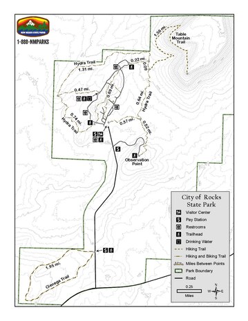
A park map is displayed to the right including the trails and other man made features, such as restrooms and the visitor center. [23]
Recreational Activities[edit]
The City of Rocks State Park has been designated as an International Dark Sky Park. Dark Sky Parks are distinctions awarded to parks that have demonstrated exceptional efforts in preserving and protecting dark skies. This recognition highlights the park's commitment to maintaining high-quality starry nights and offers opportunities to enhance visitor experiences. Additionally, achieving Dark Sky Park certification provides support from the National Park Service for expanding dark sky ranger programs and creates economic opportunities for neighboring communities through astronomy-based tourism, and increases the individuals experience while visiting. Though this certification does not carry any legal or regulatory authority, rather, it showcases the park's commitment to improving the quality of the night skies for its visitors.[24][25]
See also[edit]
References[edit]
- ^ "Gila Wilderness Site".
- ^ Breining, Greg (2007). "Most-Super Volcanoes". Super Volcano: The Ticking Time Bomb Beneath Yellowstone National Park. St. Paul, MN: Voyageur Press. p. 256 pg. ISBN 978-0-7603-2925-2.
- ^ McLemore, V.T. "City of Rocks State Park". New Mexico Bureau of Geology and Mineral Resources. New Mexico Tech. Retrieved November 18, 2020.
- ^ "Geologic Tour: City of Rocks State Park". New Mexico Bureau of Geology & Mineral Resources. Retrieved October 12, 2023.
- ^ "Mimbres Indian Pottery". The Christian Science Monitor. June 30, 1923. p. 8. ProQuest 510789104.
- ^ "City of Rocks State Park - New Mexico Tourism - Travel & Vacation Guide". www.newmexico.org. Retrieved October 3, 2023.
- ^ "City of Rocks State Park, New Mexico". Recreation.gov. Retrieved March 8, 2024.
- ^ "Butterfield Overland Mail Route". Butterfield Overland Mail Route. April 2, 2012. Retrieved March 8, 2024.
- ^ "City of Rock State Park Management Plan" (PDF). New Mexico, Energy, Minerals and Natural Resources Department. Retrieved September 24, 2010.
- ^ Matlock, Staci (April 4, 2006). "Rock lovers delight: Boulders, treasure hunting and a singing chef are all just a short drive away". Santa Fe New Mexican.
- ^ "City of Rocks State Park NM - DesertUSA". www.desertusa.com. Retrieved October 12, 2023.
- ^ "Desert Plants at City of Rocks State Park". Friends of City of Rocks. Retrieved March 7, 2024.
- ^ Walker, T. "City of Rocks State Park". State Parks. Retrieved March 7, 2024.
- ^ "Hiking". Friends of City of Rocks. Retrieved March 8, 2024.
- ^ "Hydra Trail". AllTrails.com. Retrieved October 12, 2023.
- ^ "Table Mountain". AllTrails.com. Retrieved October 12, 2023.
- ^ "Silver City to City of Rocks State Park". Silver City to City of Rocks State Park. Retrieved October 12, 2023.
- ^ Cordova, Christina (August 19, 2021). "State Parks Division works with local partners to create mural at City of Rocks State Park" (PDF). Energy, Minerals and Natural Resources Department.
{{cite news}}: CS1 maint: url-status (link) - ^ Keith, John (May 16, 1999). "New Mexico's City of Rocks Series". St. Petersburg Times. p. 4E. ProQuest 263355541.
- ^ "Visit". Friends of City of Rocks. Retrieved March 7, 2024.
- ^ Pike, David (August 1, 2015). Roadside New Mexico (Expanded ed.). University of New Mexico Press. p. 173. ISBN 9780826355690.
- ^ SOUSSAN, TANIA (May 27, 2018). "Little-knowngems - State parks offer something for everyone — fishing, hiking, more". Albuquerque Journal (NM). p. 40.
- ^ "City of Rocks State Park". State Parks. Retrieved March 8, 2024.
- ^ Driskell, Rachel (November 3, 2023). "Here are 5 places where you should camp in New Mexico". Albuquerque Journal (NM).
- ^ Moab, Mailing Address: PO Box 907; Us, UT 84532 Phone: 435 719-2299 Contact. "International Dark Sky Park FAQs - Arches National Park (U.S. National Park Service)". www.nps.gov. Retrieved March 7, 2024.
{{cite web}}: CS1 maint: numeric names: authors list (link)