
 French
 Deutsch
Cobb Peak (Utah)
| Cobb Peak | |
|---|---|
.jpg) Cobb Peak on the right, Jenkins Peak (left) South aspect, from Bonneville Salt Flats | |
| Highest point | |
| Elevation | 7,021 ft (2,140 m)[1] |
| Prominence | 1,581 ft (482 m)[2] |
| Parent peak | Graham Peak (7,563 ft)[3] |
| Isolation | 3.05 mi (4.91 km)[3] |
| Coordinates | 40°57′35″N 113°43′55″W / 40.959623°N 113.731896°W[2] |
| Naming | |
| Etymology | John Cobb |
| Geography | |
 Cobb Peak Location in Utah  Cobb Peak Cobb Peak (the United States) | |
| Location | Great Salt Lake Desert |
| Country | United States of America |
| State | Utah |
| County | Tooele |
| Parent range | Silver Island Mountains Great Basin Ranges |
| Topo map | USGS Floating Island |
| Geology | |
| Age of rock | Cambrian |
| Mountain type | Fault block |
| Type of rock | Limestone |
Cobb Peak is a 7,021-foot elevation (2,140 m) mountain summit located in Tooele County, Utah, United States.
Description[edit]
Cobb Peak is the fourth-highest summit in the Silver Island Mountains which are a subset of the Great Basin Ranges.[2] It is set on land administered by the Bureau of Land Management. The Bonneville Speedway is 12 miles to the southwest and line parent Graham Peak is three miles to the west. Topographic relief is significant as the summit rises 2,800 feet (850 meters) above the Bonneville Salt Flats in two miles. This landform's toponym was officially adopted in 1960 by the U.S. Board on Geographic Names to honor John Cobb (1899–1952), an English racing driver who set three land speed records at the Bonneville Salt Flats, including a record 394 MPH on September 16, 1947.[4][5][6]
Climate[edit]
Cobb Peak is set in the Great Salt Lake Desert which has hot summers and cold winters.[7] The desert is an example of a cold desert climate as the desert's elevation makes temperatures cooler than lower elevation deserts. Due to the high elevation and aridity, temperatures drop sharply after sunset. Summer nights are comfortably cool. Winter highs are generally above freezing, and winter nights are bitterly cold, with temperatures often dropping well below freezing.
Gallery[edit]
-
 Jenkins Peak (left), Graham Peak (center), and Cobb Peak to the right.
 -
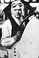 John Cobb
.jpg)
See also[edit]
References[edit]
- ^ United States Geological Survey topographical map - Floating Island
- ^ a b c "Cobb Peak, Utah". Peakbagger.com. Retrieved 2022-08-25.
- ^ a b "Cobb Peak - 7,021' UT". listsofjohn.com. Retrieved 2022-08-25.
- ^ "Cobb Peak". Geographic Names Information System. United States Geological Survey, United States Department of the Interior. Retrieved 2022-08-25.
- ^ United States Board on Geographic Names (1960), Decisions on Names in the United States, Puerto Rico and the Virgin Islands, Decision List 6001, Department of the Interior, p. 51
- ^ Northey, Tom (1974), "Land Speed Record: The Fastest Men on Earth", World of Automobiles, Vol. 10. London: Orbis, p. 1163.
- ^ Peel, M. C.; Finlayson, B. L.; McMahon, T. A. (2007). "Updated world map of the Köppen−Geiger climate classification". Hydrol. Earth Syst. Sci. 11. ISSN 1027-5606.
External links[edit]
- Cobb Peak: weather forecast