
 French
 Deutsch
File:AT0709 map.png

Size of this preview: 659 × 600 pixels. Other resolutions: 264 × 240 pixels | 527 × 480 pixels | 927 × 844 pixels.
Original file (927 × 844 pixels, file size: 29 KB, MIME type: image/png)
| This is a file from the Wikimedia Commons. Information from its description page there is shown below. Commons is a freely licensed media file repository. You can help. |
 | This locator map image could be re-created using vector graphics as an SVG file. This has several advantages; see Commons:Media for cleanup for more information. If an SVG form of this image is available, please upload it and afterwards replace this template with {{vector version available|new image name}}. It is recommended to name the SVG file “AT0709 map.svg”—then the template Vector version available (or Vva) does not need the new image name parameter. |
Summary
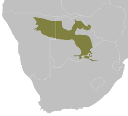
| Description | Afrikaans: Die Akasia-Kiaat sandveld-ekostreek English: Kalahari Acacia-Baikiaea woodlands ecoregion map |
| Date | |
| Source | Own work |
| Author | Altatoron |
Licensing
| I, the copyright holder of this work, release this work into the public domain. This applies worldwide. In some countries this may not be legally possible; if so: I grant anyone the right to use this work for any purpose, without any conditions, unless such conditions are required by law. |
| Annotations | This image is annotated: View the annotations at Commons |
File history
Click on a date/time to view the file as it appeared at that time.
| Date/Time | Thumbnail | Dimensions | User | Comment | |
|---|---|---|---|---|---|
| current | 09:08, 29 February 2008 | | 927 × 844 (29 KB) | Doreano~commonswiki | {{Information |Description=Kalahari Acacia-Baikiaea woodlands ecoregion map |Source=self-made |Date=2008/2/29 |Author= Altatoron |Permission= |other_versions= }} Category:Biomes Category:Biogeography [[Category:Maps of Botswana] |
File usage
The following pages on the English Wikipedia use this file (pages on other projects are not listed):
Global file usage
The following other wikis use this file:
- Usage on af.wikipedia.org
- Usage on ca.wikipedia.org
- Usage on cs.wikipedia.org
- Usage on es.wikipedia.org
- Usage on fr.wikipedia.org
- Usage on it.wikipedia.org
- Usage on ru.wikipedia.org
- Usage on uk.wikipedia.org
- Usage on www.wikidata.org