
 French
 Deutsch
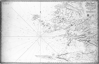
File:Admiralty Chart No 65 Brest and the Ushant Islands RMG B8780, Published 1816.jpg

Size of this preview: 800 × 520 pixels. Other resolutions: 320 × 208 pixels | 640 × 416 pixels | 1,024 × 665 pixels | 1,280 × 831 pixels | 2,560 × 1,663 pixels | 4,800 × 3,118 pixels.
Original file (4,800 × 3,118 pixels, file size: 2.05 MB, MIME type: image/jpeg)
| This is a file from the Wikimedia Commons. Information from its description page there is shown below. Commons is a freely licensed media file repository. You can help. |
Summary
| Description | English: Nautical chart of Brest and the Ushant Islands. Surveyed by Catn. Hurd 1807. Not current - not to be used for navigation! | ||||||||||
| Date | |||||||||||
| Source | A nautical survey of the Bay of Brest and the Ushant Islands by Captn Hurd RN 1807. The interior of the land taken from Cassini's corrected Map of France RMG B8780.tiff | ||||||||||
| Creator |
| ||||||||||
| Georeferencing | |||||||||||
This file was derived from: A nautical survey of the Bay of Brest and the Ushant Islands by Captn Hurd RN 1807. The interior of the land taken from Cassini's corrected Map of France RMG B8780.tiff
Licensing
This work created by the United Kingdom Government is in the public domain. This is because it is one of the following:
HMSO has declared that the expiry of Crown Copyrights applies worldwide (ref: HMSO Email Reply)
|  |
File history
Click on a date/time to view the file as it appeared at that time.
| Date/Time | Thumbnail | Dimensions | User | Comment | |
|---|---|---|---|---|---|
| current | 17:06, 16 November 2021 | | 4,800 × 3,118 (2.05 MB) | Kognos | Uploaded a work by Thomas Hurd from A nautical survey of the Bay of Brest and the Ushant Islands by Captn Hurd RN 1807. The interior of the land taken from Cassini's corrected Map of France RMG B8780.tiff with UploadWizard |
File usage
The following pages on the English Wikipedia use this file (pages on other projects are not listed):