
 French
 Deutsch
File:BENNETT BRIDGE.jpg

Size of this preview: 800 × 532 pixels. Other resolutions: 320 × 213 pixels | 640 × 426 pixels | 1,024 × 681 pixels | 1,280 × 851 pixels | 2,560 × 1,703 pixels | 5,328 × 3,544 pixels.
Original file (5,328 × 3,544 pixels, file size: 1.05 MB, MIME type: image/jpeg)
| This is a file from the Wikimedia Commons. Information from its description page there is shown below. Commons is a freely licensed media file repository. You can help. |
Summary
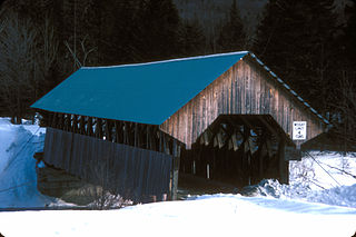
| Description | English: NEAR WILSON’S MILLS; 1901, 80’ PADDLEFORD OVER MAGELLOWAT RIVER
| ||
| Date | |||
| Source | Own work | ||
| Author | JERRYE & ROY KLOTZ MD |
| Object location | | View this and other nearby images on: OpenStreetMap |
|---|
Licensing
I, the copyright holder of this work, hereby publish it under the following license:
This file is licensed under the Creative Commons Attribution-Share Alike 3.0 Unported license.
- You are free:
- to share – to copy, distribute and transmit the work
- to remix – to adapt the work
- Under the following conditions:
- attribution – You must give appropriate credit, provide a link to the license, and indicate if changes were made. You may do so in any reasonable manner, but not in any way that suggests the licensor endorses you or your use.
- share alike – If you remix, transform, or build upon the material, you must distribute your contributions under the same or compatible license as the original.
File history
Click on a date/time to view the file as it appeared at that time.
| Date/Time | Thumbnail | Dimensions | User | Comment | |
|---|---|---|---|---|---|
| current | 02:25, 14 December 2012 | | 5,328 × 3,544 (1.05 MB) | Ras67 | losslessly cropped with Jpegcrop |
| 00:06, 1 December 2012 |  | 5,782 × 3,946 (1.41 MB) | KLOTZ | User created page with UploadWizard |
File usage
The following pages on the English Wikipedia use this file (pages on other projects are not listed):
Global file usage
The following other wikis use this file:
- Usage on www.wikidata.org
- Usage on zh.wikipedia.org