
 French
 Deutsch
File:Clarksville-TN-KY MSA.jpg
Clarksville-TN-KY_MSA.jpg (475 × 461 pixels, file size: 36 KB, MIME type: image/jpeg)
Summary[edit]
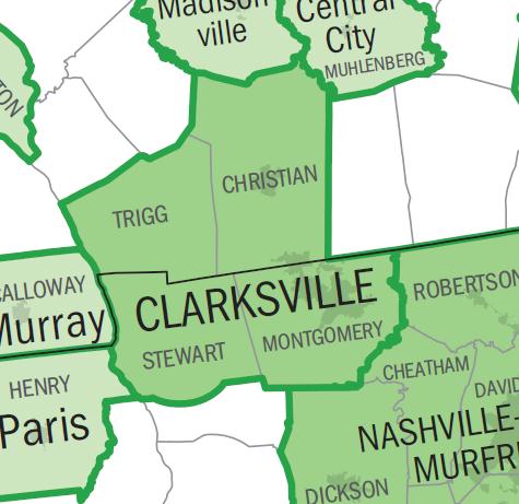
| Description | This is a representation of the Clarksville metropolitan area. | ||
|---|---|---|---|
| Source | Uploader created this image using a U.S. Census Bureau map image from Metropolitan and Micropolitan Statistical Areas Wall Maps: November 2004. As this image was originally generated by the U.S. federal government, it is considered to be public domain. | ||
| Date | |||
| Author |
| ||
| Permission (Reusing this file) | See below.
|
Licensing:[edit]
| This image is a work of a United States Census Bureau employee, taken or made as part of that person's official duties. As a work of the U.S. federal government, the image is in the public domain in the United States. |  |
 | This file is a candidate to be copied to Wikimedia Commons. Any user may perform this transfer; refer to Wikipedia:Moving files to Commons for details. If this file has problems with attribution, copyright, or is otherwise ineligible for Commons, then remove this tag and DO NOT transfer it; repeat violators may be blocked from editing. Other Instructions
| ||
| |||
| This media file is either in the public domain or published under a free license, and contains no inbound file links. If this media file is useful, then it should be transferred to the Wikimedia Commons. If this media is not useful, then please propose it for deletion or list it at files for discussion. |
File history
Click on a date/time to view the file as it appeared at that time.
| Date/Time | Thumbnail | Dimensions | User | Comment | |
|---|---|---|---|---|---|
| current | 21:28, 19 February 2011 | | 475 × 461 (36 KB) | Riffsyphon1024 (talk | contribs) | == Summary == This is a representation of the Clarksville metropolitan area. I created this image using a U.S. Census Bureau map image from [http://www.census.gov/geo/www/maps/msa_maps2004/us_wall_1104.htm Metropolitan and Micropolitan Statistical A |
You cannot overwrite this file.