
 French
 Deutsch
File:Comparison azimuthal projections.svg

Size of this PNG preview of this SVG file: 512 × 171 pixels. Other resolutions: 320 × 107 pixels | 640 × 214 pixels | 1,024 × 342 pixels | 1,280 × 428 pixels | 2,560 × 855 pixels.
Original file (SVG file, nominally 512 × 171 pixels, file size: 113 KB)
| This is a file from the Wikimedia Commons. Information from its description page there is shown below. Commons is a freely licensed media file repository. You can help. |
Summary
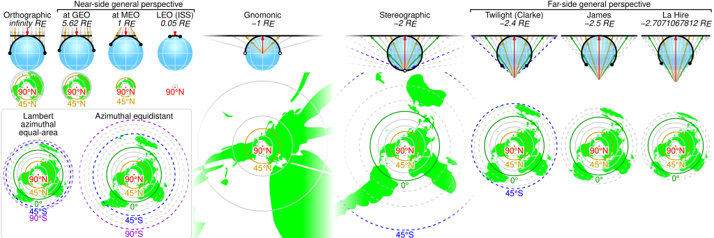
| Description | English: Comparison of some azimuthal projections of the world map based on information on http://www.progonos.com/furuti/MapProj/Normal/ProjAz/projAz.html . Values indicated are mean altitudes in terms of Earth radii. Circles denote latitudes of multiples of 15-degrees (dashed lines represent the southern hemisphere). In the SVG file, hover over a circle to show its latitude in a tooltip. |
| Source | Own work |
| Author | Cmglee |
| SVG development | This vector image was created with Python. |
Licensing
I, the copyright holder of this work, hereby publish it under the following licenses:
This file is licensed under the Creative Commons Attribution-Share Alike 3.0 Unported license.
- You are free:
- to share – to copy, distribute and transmit the work
- to remix – to adapt the work
- Under the following conditions:
- attribution – You must give appropriate credit, provide a link to the license, and indicate if changes were made. You may do so in any reasonable manner, but not in any way that suggests the licensor endorses you or your use.
- share alike – If you remix, transform, or build upon the material, you must distribute your contributions under the same or compatible license as the original.
 | Permission is granted to copy, distribute and/or modify this document under the terms of the GNU Free Documentation License, Version 1.2 or any later version published by the Free Software Foundation; with no Invariant Sections, no Front-Cover Texts, and no Back-Cover Texts. A copy of the license is included in the section entitled GNU Free Documentation License. |
You may select the license of your choice.
File history
Click on a date/time to view the file as it appeared at that time.
| Date/Time | Thumbnail | Dimensions | User | Comment | |
|---|---|---|---|---|---|
| current | 00:42, 3 June 2019 | 512 × 171 (113 KB) | Cmglee | Put a box around equal-area and equidistant projections. | |
| 09:09, 6 November 2017 | 512 × 171 (113 KB) | Cmglee | Use <?xml version="1.0" encoding="utf-8"?> instead of <!DOCTYPE svg PUBLIC "-//W3C//DTD SVG 1.1//EN" "http://www.w3.org/Graphics/SVG/1.1/DTD/svg11.dtd"> . | ||
| 09:42, 5 November 2017 | 512 × 171 (113 KB) | Cmglee | Change primary font to Helvetica and restore minus signs as thumbnail generation is broken (degrees appear as "?"). | ||
| 09:40, 5 November 2017 | 512 × 171 (113 KB) | Cmglee | Use plain "-" as en dashes don't appear in thumbnail. | ||
| 09:37, 5 November 2017 | 512 × 171 (113 KB) | Cmglee | Replace minus signs with en dashes as they don't appear in thumbnails. | ||
| 09:32, 5 November 2017 | 512 × 171 (113 KB) | Cmglee | Add map and tooltips. | ||
| 01:25, 27 February 2015 | 512 × 171 (56 KB) | Cmglee | Fix azimuthal equidistant scale and tweak globe and labels. | ||
| 01:06, 25 February 2015 | 512 × 171 (52 KB) | Cmglee | Further increase font size. | ||
| 00:17, 25 February 2015 | 512 × 171 (52 KB) | Cmglee | Fix font size and line width. | ||
| 00:15, 25 February 2015 | 512 × 171 (52 KB) | Cmglee | {{Information |Description ={{en|1=Comparison of some azimuthal projections of the world map based on information on http://www.progonos.com/furuti/MapProj/Normal/ProjAz/projAz.html . Values indicated are mean altitudes in terms of Earth radii. Circ... |
File usage
The following 10 pages use this file:
Global file usage
The following other wikis use this file:
- Usage on de.wikipedia.org
- Usage on es.wikipedia.org
- Usage on fi.wikipedia.org
- Usage on ja.wikipedia.org
- Usage on zh.wikipedia.org