
 French
 Deutsch
File:Fort-lyon-alexandria-virginia-vhs00032-1-.jpg
Size of this preview: 447 × 600 pixels. Other resolutions: 179 × 240 pixels | 358 × 480 pixels | 572 × 768 pixels | 763 × 1,024 pixels | 1,609 × 2,158 pixels.
Original file (1,609 × 2,158 pixels, file size: 1.17 MB, MIME type: image/jpeg)
| This is a file from the Wikimedia Commons. Information from its description page there is shown below. Commons is a freely licensed media file repository. You can help. |
Summary
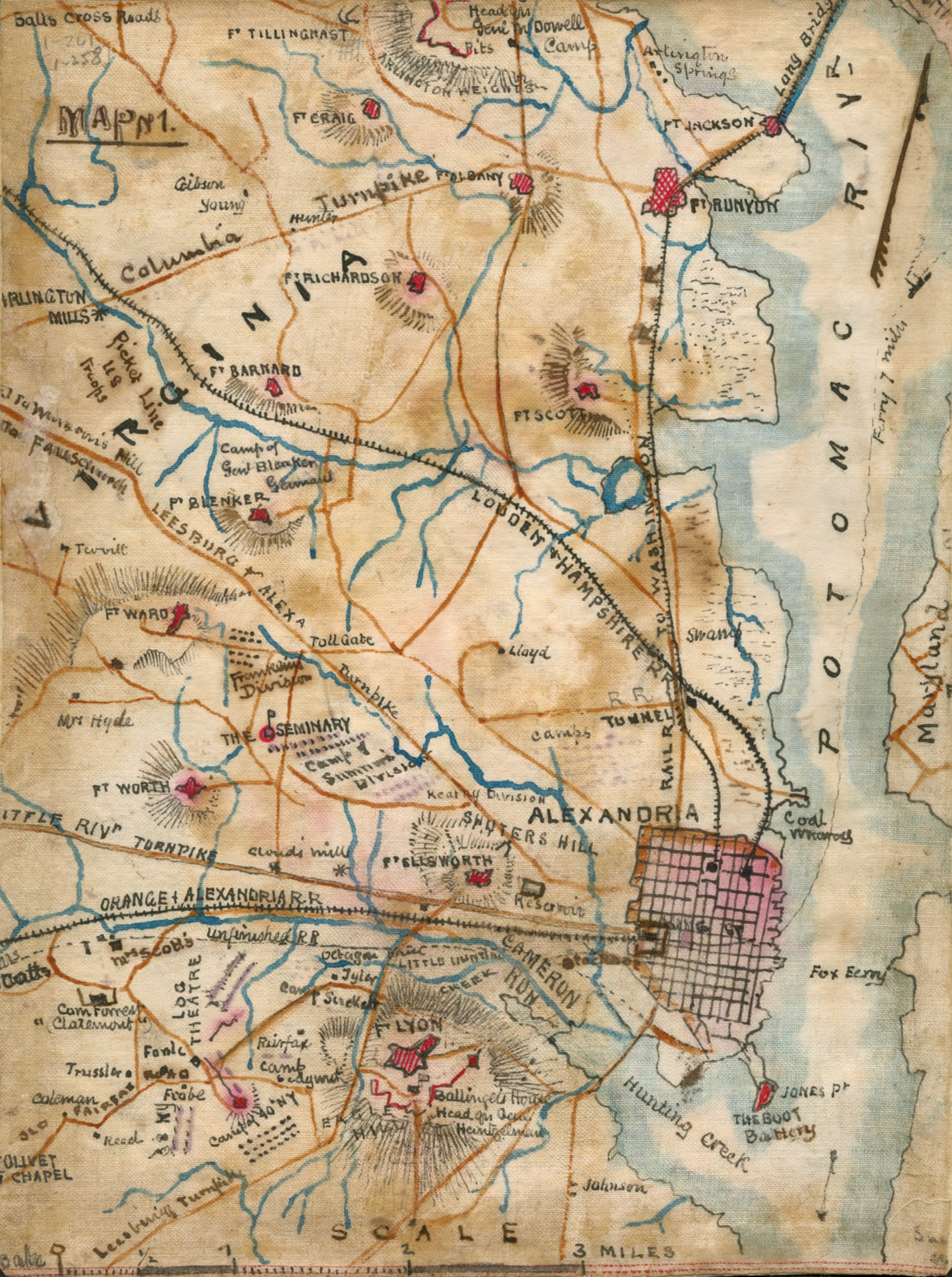
| Description | English: Illustrates Alexandria's central position in the defense of Washington, where at least 12 outlying forts surrounded the city. Military camps of various Union officers such as Samuel Peter Heintzelman are indicated on this ca. September 1861 map. | ||
| Source |
| ||
| Author | {Creator:Robert Knox Sneden |

|Date=1862-05 |Permission=
This image is a work of a U.S. military or Department of Defense employee, taken or made as part of that person's official duties. As a work of the U.S. federal government, the image is in the public domain in the United States.
|  |
|other_versions= }}
Licensing
The author died in 1918, so this work is in the public domain in its country of origin and other countries and areas where the copyright term is the author's life plus 100 years or fewer. | |
| This file has been identified as being free of known restrictions under copyright law, including all related and neighboring rights. | |
File history
Click on a date/time to view the file as it appeared at that time.
| Date/Time | Thumbnail | Dimensions | User | Comment | |
|---|---|---|---|---|---|
| current | 14:40, 15 June 2012 | | 1,609 × 2,158 (1.17 MB) | Ras67 | slightly rotated and cropped from the jp2 source |
| 04:43, 29 February 2012 |  | 1,696 × 2,208 (128 KB) | Kramer Associates | Losslessly cropped | |
| 20:44, 21 December 2008 |  | 1,748 × 2,238 (106 KB) | Pohick2 | {{Information |Description= |Source= |Date= |Author= |Permission= |other_versions= }} | |
| 01:43, 11 December 2008 |  | 1,748 × 2,238 (95 KB) | Pohick2 | {{Information |Description={{en|1=Illustrates Alexandria's central position in the defense of Washington, where at least 12 outlying forts surrounded the city. Military camps of various Union officers such as Samuel Peter Heintzelman are indicated on this |
File usage
The following pages on the English Wikipedia use this file (pages on other projects are not listed):
Global file usage
The following other wikis use this file:
- Usage on fr.wikipedia.org