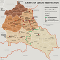
File:General Government camps of Lublin Reservation.png

Size of this preview: 605 × 600 pixels. Other resolutions: 242 × 240 pixels | 484 × 480 pixels | 774 × 768 pixels | 1,033 × 1,024 pixels | 2,299 × 2,280 pixels.
Original file (2,299 × 2,280 pixels, file size: 636 KB, MIME type: image/png)
File history
Click on a date/time to view the file as it appeared at that time.
| Date/Time | Thumbnail | Dimensions | User | Comment | |
|---|---|---|---|---|---|
| current | 17:14, 3 May 2018 |  | 2,299 × 2,280 (636 KB) | Poeticbent | added location of Kulmhof to map & legend |
| 17:10, 17 April 2016 |  | 2,299 × 2,280 (620 KB) | Poeticbent | added missing locations | |
| 04:35, 15 April 2016 |  | 2,299 × 2,280 (609 KB) | Poeticbent | =={{int:filedesc}}== {{Information |description={{en|1=Map of the administrative areas of the General Government}} |date=2012-05-26 |source={{own}} by {{u|XrysD}}, edited by {{u|Poeticbent}} with superimposed camps of Lublin Reservation before and afte... |
File usage
The following pages on the English Wikipedia use this file (pages on other projects are not listed):
Global file usage
The following other wikis use this file:
- Usage on de.wikipedia.org
- Usage on el.wikipedia.org
- Usage on es.wikipedia.org
- Usage on fr.wikipedia.org
- Usage on it.wikipedia.org
- Usage on no.wikipedia.org
- Usage on pl.wikipedia.org
- Usage on zh.wikipedia.org


 French
 Deutsch