
 French
 Deutsch
File:Great Basin map.gif

Size of this preview: 537 × 600 pixels. Other resolutions: 215 × 240 pixels | 430 × 480 pixels | 687 × 768 pixels | 1,074 × 1,200 pixels.
Original file (1,074 × 1,200 pixels, file size: 342 KB, MIME type: image/gif, 0.1 s)
| This is a file from the Wikimedia Commons. Information from its description page there is shown below. Commons is a freely licensed media file repository. You can help. |
Summary
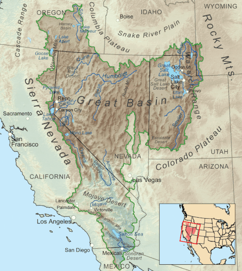
| Description | Map showing the Great Basin drainage basin as defined hydrologically. |
| Date | (UTC) |
| Source | This file was derived from: Greatbasinmap.png:  |
| Author |
|
Licensing
Kmusser at Wikimedia Commons, the copyright holder of this work, hereby publishes it under the following license:
This file is licensed under the Creative Commons Attribution-Share Alike 3.0 Unported license.
Attribution: Kmusser at Wikimedia Commons
- You are free:
- to share – to copy, distribute and transmit the work
- to remix – to adapt the work
- Under the following conditions:
- attribution – You must give appropriate credit, provide a link to the license, and indicate if changes were made. You may do so in any reasonable manner, but not in any way that suggests the licensor endorses you or your use.
- share alike – If you remix, transform, or build upon the material, you must distribute your contributions under the same or compatible license as the original.
Original upload log
This image is a derivative work of the following images:
- File:Greatbasinmap.png licensed with Cc-by-sa-3.0
- 2020-09-04T22:25:15Z Nwbeeson 1500x1676 (7565343 Bytes) Added boundary map. Second attempt to upload the image.
- 2020-09-04T22:21:06Z Nwbeeson 1500x1676 (7564895 Bytes) Added boundary line.
- 2010-12-11T16:58:55Z Kmusser 1500x1676 (3820728 Bytes) Added Goose Lake
- 2010-11-17T20:37:07Z Kmusser 1500x1676 (3382394 Bytes) == Summary == {{Information |Description=Map showing the [[:w:Great Basin|Great Basin]] drainage basin as defined hydrologically. |Source={{own}}, Elevation data from [[:w:Shuttle Radar Topography Mission|SRTM]], all other fe
Uploaded with derivativeFX
File history
Click on a date/time to view the file as it appeared at that time.
| Date/Time | Thumbnail | Dimensions | User | Comment | |
|---|---|---|---|---|---|
| current | 22:05, 7 May 2022 | | 1,074 × 1,200 (342 KB) | Hike395 | == {{int:filedesc}} == {{Information |Description=Map showing the Great Basin drainage basin as defined hydrologically. |Source={{Derived from|Greatbasinmap.png|display=50}} |Date=2022-05-07 22:03 (UTC) |Author=* File:Greatbasinmap.png: Kmusser * conversion to gif: [[User:{{subst:REVISIONUSER}}|{{subst:REVISIONUSER}}]] |Permission= |other_versions= }} == {{int:license-header}} == {{self|author={{user at project|Kmusser|c}}|Cc-by... |
File usage
The following 21 pages use this file:
- Antelope Valley (Eureka County)
- Antelope Valley (southwest Millard County, Utah)
- Bear River (Great Salt Lake)
- Dixie Valley
- Fish Lake Valley
- Geology of the United States
- Great Basin
- Great Basin Divide
- Indian Springs Pass
- List of Great Basin watersheds
- List of deserts by area
- List of rivers of the Americas
- List of rivers of the Great Basin
- Numaga
- Rain shadow
- Weber River
- Talk:Great Basin
- User:Mmcannis/sandbox/Indian Springs Pass
- User:Mmcannis/sandbox/McCullough Range south Triple Point (water divide)
- User:Mmcannis/sandbox/Original-New York Mountains north divide
- Template:Great Basin watersheds
Global file usage
The following other wikis use this file:
- Usage on fi.wikipedia.org
- Usage on hy.wikipedia.org
- Usage on ro.wikipedia.org
- Usage on sd.wikipedia.org
- Usage on si.wikipedia.org
- Usage on www.wikidata.org