
 French
 Deutsch
File:Historic American Buildings Survey Robert W. Kerrigan, Photographer Original- May 1936 VIEW FROM NORTHWEST - Francisco Sanchez Adobe, Linda Mar Boulevard and Adobe Drive, Pacifica HABS CAL,41- ,1-3.tif

Size of this JPG preview of this TIF file: 800 × 580 pixels. Other resolutions: 320 × 232 pixels | 640 × 464 pixels | 1,024 × 742 pixels | 1,280 × 928 pixels | 2,560 × 1,855 pixels | 5,000 × 3,624 pixels.
Original file (5,000 × 3,624 pixels, file size: 17.28 MB, MIME type: image/tiff)
| This is a file from the Wikimedia Commons. Information from its description page there is shown below. Commons is a freely licensed media file repository. You can help. |
Summary
| Historic American Buildings Survey Robert W. Kerrigan, Photographer Original- May 1936 VIEW FROM NORTHWEST - Francisco Sanchez Adobe, Linda Mar Boulevard and Adobe Drive, Pacifica, San Mateo County, CA | ||||
|---|---|---|---|---|
| Title | Historic American Buildings Survey Robert W. Kerrigan, Photographer Original- May 1936 VIEW FROM NORTHWEST - Francisco Sanchez Adobe, Linda Mar Boulevard and Adobe Drive, Pacifica, San Mateo County, CA | |||
| Depicted place | California; San Mateo County; Pacifica | |||
| Date | Documentation compiled after 1933 | |||
| Dimensions | 5 x 7 in. | |||
| Current location | Library of Congress Prints and Photographs Division Washington, D.C. 20540 USA http://hdl.loc.gov/loc.pnp/pp.print | |||
| Accession number | HABS CAL,41-____,1-3 | |||
| Credit line |
| |||
| Notes |
| |||
| Source | https://www.loc.gov/pictures/item/ca0852.photos.017839p | |||
| Permission (Reusing this file) |
| |||

| Camera location | | View this and other nearby images on: OpenStreetMap |
|---|
File history
Click on a date/time to view the file as it appeared at that time.
| Date/Time | Thumbnail | Dimensions | User | Comment | |
|---|---|---|---|---|---|
| current | 05:32, 4 July 2014 | 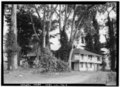 | 5,000 × 3,624 (17.28 MB) | Fæ | GWToolset: Creating mediafile for Fæ. HABS 3 July 2014 (201:300) |
File usage
The following pages on the English Wikipedia use this file (pages on other projects are not listed):