
 French
 Deutsch
File:Land loss in coastal Louisiana since 1932 NOAA2013.jpg
Size of this preview: 462 × 599 pixels. Other resolutions: 185 × 240 pixels | 370 × 480 pixels | 776 × 1,006 pixels.
Original file (776 × 1,006 pixels, file size: 289 KB, MIME type: image/jpeg)
| This is a file from the Wikimedia Commons. Information from its description page there is shown below. Commons is a freely licensed media file repository. You can help. |
Summary
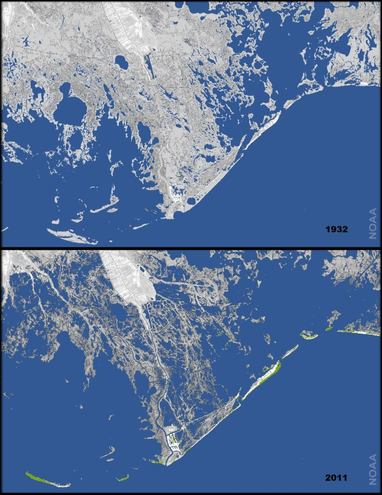
| Description | Français : Perte de sols marécageux en Lousiane en 80 ans, de 1932 à 2011 dans le Delta du Mississippi en raison de l'augmentation du niveau relatif de la mer, par effets combinés de la montée de la mer et de l'affaissement des sols, notamment du aux pompage du gaz et du pétrole sous-jacents et à l'endiguement du Mississippi et aux nombreux canaux de drainage ou de circulation creusés dans les marais depuis un siècle. 25 à 35 miles au carré de surface ont été perdus chaque année durant 80 ans. source : Underwater: Land loss in coastal Louisiana since 1932 (click under the picture to see the two maps), on line 2013-04-04 English: Every year, 25-35 square miles of land off the coast of Louisiana—an area larger than Manhattan–disappears into the water due to a combination of subsidence (soil settling) and global sea level rise. The maps at right show how much land has been lost to the Gulf of Mexico in the past 80 year. The second image shows the state of the coast in 1932. The image combines the 2011 satellite image with a U.S. Geological Survey map in which land areas that were present in 1932 are light gray. Since the 1930s, (source : NOAA ; Underwater: Land loss in coastal Louisiana since 1932 (click under the picture to see the two maps), on line 2013-04-04 |
| Date | |
| Source | NOAA : Underwater: Land loss in coastal Louisiana since 1932 (click under the picture to see the two maps), on line 2013-04-04 |
| Author | NOAA |
seel also : Underwater: Land loss in coastal Louisiana since 1932 (2013-04-04)
Licensing
This image is in the public domain because it contains materials that originally came from the U.S. National Oceanic and Atmospheric Administration, taken or made as part of an employee's official duties.
|
File history
Click on a date/time to view the file as it appeared at that time.
| Date/Time | Thumbnail | Dimensions | User | Comment | |
|---|---|---|---|---|---|
| current | 10:30, 30 August 2014 | | 776 × 1,006 (289 KB) | Lamiot | User created page with UploadWizard |
File usage
The following pages on the English Wikipedia use this file (pages on other projects are not listed):
Global file usage
The following other wikis use this file:
- Usage on de.wikipedia.org
- Usage on fr.wikipedia.org
- Usage on it.wikipedia.org
- Usage on pt.wikipedia.org
- Usage on ru.wikipedia.org
- Usage on scn.wikipedia.org
- Usage on tr.wikipedia.org
- Usage on www.wikidata.org