
 French
 Deutsch
File:Mahabharata BharatVarsh.jpg

Original file (4,581 × 5,476 pixels, file size: 4.05 MB, MIME type: image/jpeg)
| This is a file from the Wikimedia Commons. Information from its description page there is shown below. Commons is a freely licensed media file repository. You can help. |
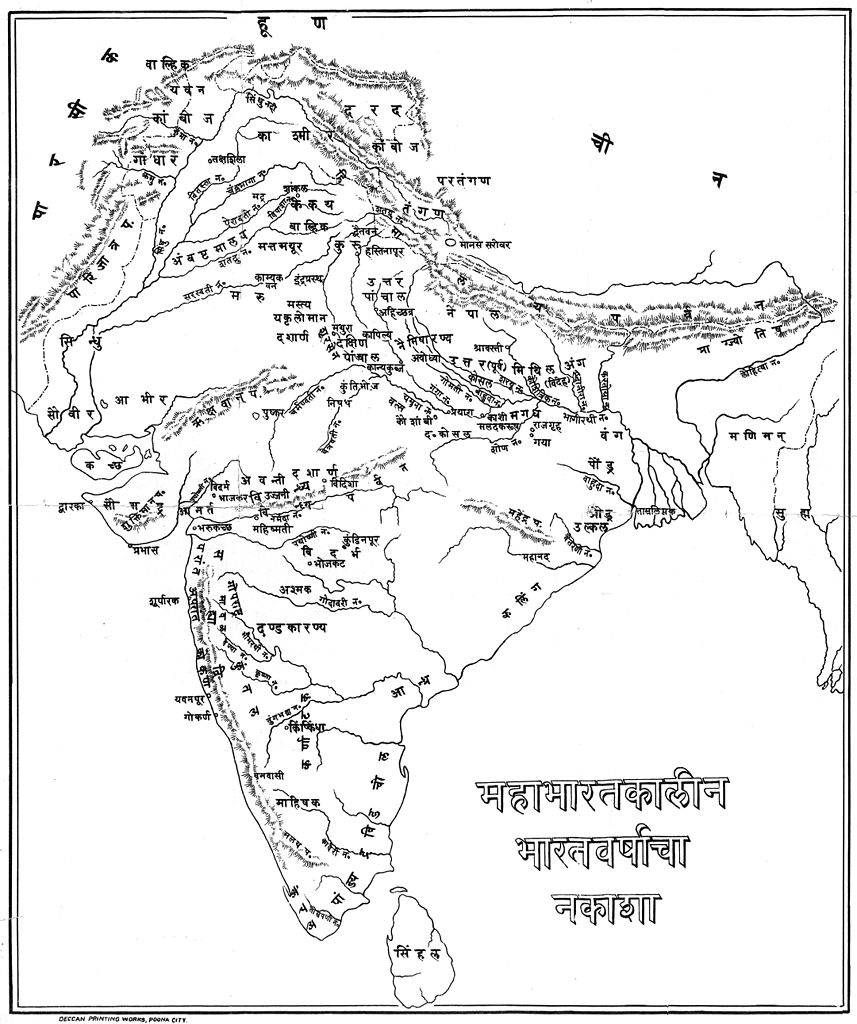
Summary
| Description | English: Shows place names in India associated with the Mahābhārāta (an important source for a knowledge of Hinduism as it evolved during the period ca. 400 B.C. to 200 A.D.). Relief shown by hachures. Language: Publication origin of the map is Pune, India. Map title is in Marathi language. Name of the locations are in Sanskrit. Mounted on cloth backing ; 45 x 38 cm. | ||
| Source |
| ||
| Author | Deccan Printing Works, Poona City. |

Licensing
This work is in the public domain in India because its term of copyright has expired. The Indian Copyright Act applies in India to works first published in India. According to the Indian Copyright Act, 1957, as amended up to Act No. 27 of 2012 (Chapter V, Section 25):
|  |
This work is in the public domain in the United States because it meets three requirements:
For background information, see the explanation on Non-U.S. copyrights. This template applies to works first published in India. For anonymous works, photographs, cinematographic works, government works, works of corporate authorship or of international organizations, and posthumous works (other than those above), this template applies to works published before January 1, 1941, and for any other kind of work, this template applies if the author died before January 1, 1941. Please also note that this template should not be used for sound recordings.
|
| date/time | username | edit summary |
|---|---|---|
| 15:00, 20 December 2005 | en:User:Miljoshi | (<span class="autocomment"><a href="Image:Mahabharata_BharatVarsh.jpg#Summary" title="Image:Mahabharata BharatVarsh.jpg">→</a>Summary -</span> added title details) |
| 14:50, 20 December 2005 | en:User:Miljoshi | (<span class="autocomment"><a href="Image:Mahabharata_BharatVarsh.jpg#Summary" title="Image:Mahabharata BharatVarsh.jpg">→</a>Summary -</span> - removed link that is not working) |
| 14:48, 20 December 2005 | en:User:Miljoshi | (<span class="autocomment"><a href="Image:Mahabharata_BharatVarsh.jpg#Summary" title="Image:Mahabharata BharatVarsh.jpg">→</a>Summary</span>) |
| 14:48, 20 December 2005 | en:User:Miljoshi | (Credit Line: Library of Congress, Geography and Map Division Notice: http://memory.loc.gov/ammem/gmdhtml/gmdres.html Source: http://memory.loc.gov/cgi-bin/query/D?gmd:39:./temp/~ammem_Gi7n:: I have resized the image for better visibility.) |
Original upload log
Legend: (cur) = this is the current file, (del) = delete this old version, (rev) = revert to this old version.
Click on date to download the file or see the image uploaded on that date.
- (del) (cur) 14:48, 20 December 2005 . . en:User:Miljoshi Miljoshi ( en:User_talk:Miljoshi Talk) . . 934x1155 (433997 bytes) (Credit Line: Library of Congress, Geography and Map Division Notice: http://memory.loc.gov/ammem/gmdhtml/gmdres.html Source: http://memory.loc.gov/cgi-bin/query/D?gmd:39:./temp/~ammem_Gi7n:: I have resized the image for better visibility.)
File history
Click on a date/time to view the file as it appeared at that time.
| Date/Time | Thumbnail | Dimensions | User | Comment | |
|---|---|---|---|---|---|
| current | 04:55, 23 January 2017 | | 4,581 × 5,476 (4.05 MB) | Shyamal | Clean a better version without cropping out the right edge |
| 15:16, 11 September 2012 |  | 934 × 1,155 (688 KB) | Yann | color balance, contrast, color corrections | |
| 10:20, 12 March 2006 |  | 934 × 1,155 (424 KB) | Maksim | La bildo estas kopiita de wikipedia:en. La originala priskribo estas: == Summary == Credit Line: Library of Congress, Geography and Map Division Notice: http://memory.loc.gov/ammem/gmdhtml/gmdres.html Language: Publication origin of the map is Pune |
File usage
Global file usage
The following other wikis use this file:
- Usage on bs.wikipedia.org
- Usage on gu.wikipedia.org
- Usage on hi.wikipedia.org
- Usage on hr.wikipedia.org
- Usage on id.wikipedia.org
- Usage on mai.wikipedia.org
- Usage on mr.wikipedia.org
- Usage on ne.wikipedia.org
- Usage on pl.wikipedia.org
- Usage on ro.wikipedia.org
- Usage on ru.wikipedia.org
- Usage on sa.wikipedia.org
- Usage on sa.wikisource.org
- Usage on sh.wikipedia.org
- Usage on sr.wikipedia.org
- Usage on ta.wikipedia.org
- Usage on te.wikipedia.org