
 French
 Deutsch
File:Map of Rhode Island NA.png
Size of this preview: 776 × 600 pixels. Other resolutions: 311 × 240 pixels | 621 × 480 pixels | 994 × 768 pixels | 1,280 × 989 pixels | 2,122 × 1,640 pixels.
Original file (2,122 × 1,640 pixels, file size: 822 KB, MIME type: image/png)
| This is a file from the Wikimedia Commons. Information from its description page there is shown below. Commons is a freely licensed media file repository. You can help. |
Summary
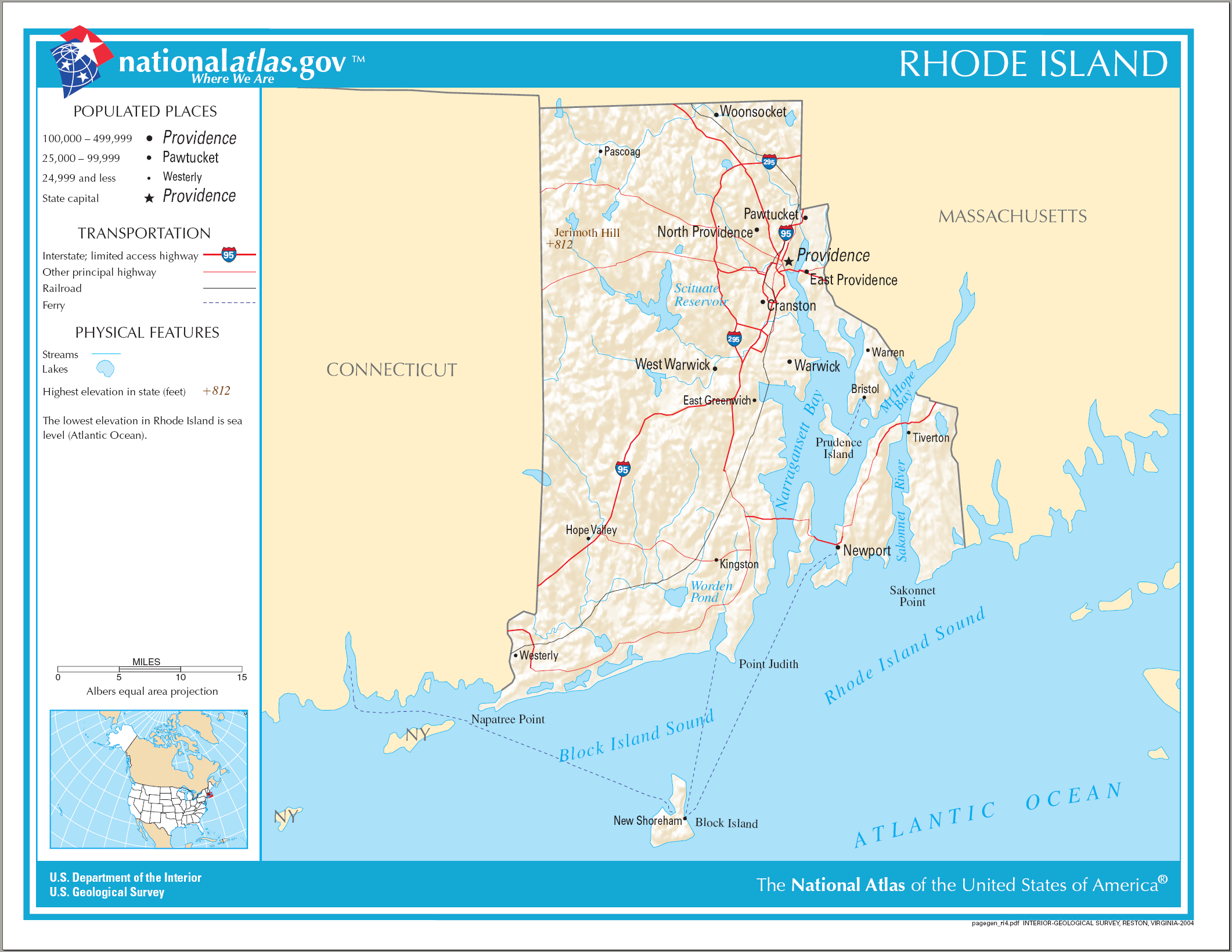
| Description | English: National Atlas map of Rhode Island. |
| Date | |
| Source | National Atlas |
| Author |
Licensing
This map was obtained from an edition of the National Atlas of the United States. Like almost all works of the U.S. federal government, works from the National Atlas are in the public domain in the United States. Online access: NationalAtlas.gov | 1970 print edition: Library of Congress, Perry-Castañeda Library
|
File history
Click on a date/time to view the file as it appeared at that time.
| Date/Time | Thumbnail | Dimensions | User | Comment | |
|---|---|---|---|---|---|
| current | 14:16, 17 April 2015 | | 2,122 × 1,640 (822 KB) | RokerHRO | optipng -o7 -i0 → 18.34% decrease |
| 08:22, 15 August 2006 |  | 2,122 × 1,640 (1,007 KB) | Huebi~commonswiki | {{Information| |Description=Map of Rhode Island |Source=[http://www.nationalatlas.gov National Atlas] }} Category:Maps of the United States Category:Maps of Rhode Island {{PD-USGov-Atlas}} |
File usage
The following pages on the English Wikipedia use this file (pages on other projects are not listed):
Global file usage
The following other wikis use this file:
- Usage on ang.wikipedia.org
- Usage on be.wikipedia.org
- Usage on ca.wikipedia.org
- Usage on de.wikipedia.org
- Usage on fi.wikipedia.org
- Usage on ga.wikipedia.org
- Usage on gl.wikipedia.org
- Usage on hu.wikipedia.org
- Usage on hy.wikipedia.org
- Usage on ja.wikipedia.org
- Usage on ko.wikipedia.org
- Usage on lt.wikipedia.org
- Usage on mhr.wikipedia.org
- Usage on mr.wikipedia.org
- Usage on os.wikipedia.org
- Usage on sw.wikipedia.org
- Usage on tg.wikipedia.org
- Usage on tt.wikipedia.org
- Usage on www.wikidata.org
- Usage on zea.wikipedia.org