
 French
 Deutsch
File:Map of the Kingdom of Galicia, 1914.jpg
No higher resolution available.
Map_of_the_Kingdom_of_Galicia,_1914.jpg (598 × 450 pixels, file size: 157 KB, MIME type: image/jpeg)
| This is a file from the Wikimedia Commons. Information from its description page there is shown below. Commons is a freely licensed media file repository. You can help. |
{{DVG|== Summary ==
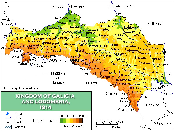
| Description | English: Map of the Kingdom of Galicia, 1914/Mapa fizyczna Galicji 1846-1918 |
| Date | |
| Source | Own work |
| Author | Mariusz Paździora |
| Other versions | image:Galicia physical1914-de.png German |
 | This historical map image could be re-created using vector graphics as an SVG file. This has several advantages; see Commons:Media for cleanup for more information. If an SVG form of this image is available, please upload it and afterwards replace this template with {{vector version available|new image name}}. It is recommended to name the SVG file “Map of the Kingdom of Galicia, 1914.svg”—then the template Vector version available (or Vva) does not need the new image name parameter. |


Licensing
I, the copyright holder of this work, hereby publish it under the following license:
This file is licensed under the Creative Commons Attribution 3.0 Unported license.
- You are free:
- to share – to copy, distribute and transmit the work
- to remix – to adapt the work
- Under the following conditions:
- attribution – You must give appropriate credit, provide a link to the license, and indicate if changes were made. You may do so in any reasonable manner, but not in any way that suggests the licensor endorses you or your use.
File history
Click on a date/time to view the file as it appeared at that time.
| Date/Time | Thumbnail | Dimensions | User | Comment | |
|---|---|---|---|---|---|
| current | 07:13, 9 November 2021 | | 598 × 450 (157 KB) | Alphathon | Corrected Bukovinan and Romanian borders |
| 09:02, 10 March 2020 |  | 598 × 450 (310 KB) | Claude Zygiel | Kingdom of Poland was a part of the Russian Empire, kingdom of Hungary was a part of Austria-Hungary, and Galicia, Bucovina and Austrian Silesia were lands of the Austrian part. | |
| 18:40, 18 May 2011 |  | 598 × 450 (193 KB) | VT | - Slovakia was not present then - Austria-Hungary was changed to Kingdom of Hungary: as the map shows several parts of Austro-Hungarian Monarchy, even Galicia, Bukovina and Austrian Silesia were the parts of it, not just Hungary. | |
| 18:01, 2 April 2008 |  | 598 × 450 (343 KB) | Kiejstut9 | {{Information |Description=Map of the Kingdom of Galicia, 1914 |Source=self-made |Date=2008 |Author= Kiejstut9 |Permission= |other_versions= }} |
File usage
The following pages on the English Wikipedia use this file (pages on other projects are not listed):
Global file usage
The following other wikis use this file:
- Usage on bg.wikipedia.org
- Usage on ca.wikipedia.org
- Usage on da.wikipedia.org
- Usage on de.wikipedia.org
- Usage on el.wikipedia.org
- Usage on es.wikipedia.org
- Usage on et.wikipedia.org
- Usage on eu.wiktionary.org
- Usage on fa.wikipedia.org
- Usage on fr.wikipedia.org
- Usage on gl.wikipedia.org
- Usage on he.wikipedia.org
- Usage on hu.wikipedia.org
- Usage on it.wikipedia.org
- Usage on ja.wikipedia.org
- Usage on la.wikipedia.org
- Usage on mk.wikipedia.org
- Usage on nl.wikipedia.org
- Usage on nn.wikipedia.org
- Usage on no.wikipedia.org
- Usage on pl.wikipedia.org
- Usage on pl.wiktionary.org
- Usage on pt.wikipedia.org
- Usage on ro.wikipedia.org
- Usage on scn.wikipedia.org
- Usage on sh.wikipedia.org
- Usage on sl.wikipedia.org
- Usage on sr.wikipedia.org
- Usage on sv.wikipedia.org
- Usage on yi.wikipedia.org
- Usage on zh.wikipedia.org