
 French
 Deutsch
File:MetroWest ma highlight.png
No higher resolution available.
MetroWest_ma_highlight.png (788 × 466 pixels, file size: 59 KB, MIME type: image/png)
| This is a file from the Wikimedia Commons. Information from its description page there is shown below. Commons is a freely licensed media file repository. You can help. |
Summary
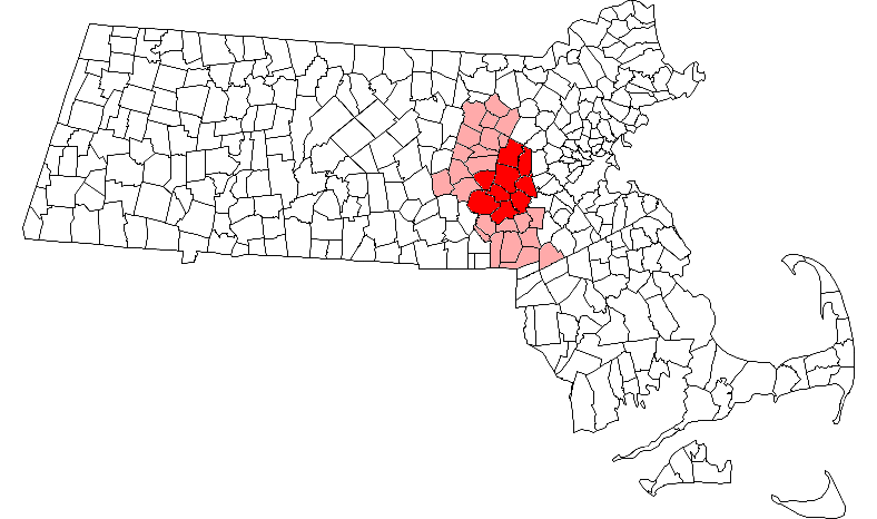
| Description | English: Map of Massachusetts towns with the 9 MetroWest towns (defined by the MetroWest Economic Research Center at Framingham State College) highlighted in red, and the 23 other municipalities included in the 495/MetroWest Corridor (as defined by the 495/MetroWest Corridor Partnership) highlighted in pink |
| Date | |
| Source | This file was derived from: Framingham ma highlight.png |
| Author | Justin H. Petrosek, modified by Scott D. Mainwaring (ScottMainwaring at English Wikipedia) |
Licensing
| This file is licensed under the Creative Commons Attribution-Share Alike 3.0 Unported license. Subject to disclaimers. | ||
| ||
| This licensing tag was added to this file as part of the GFDL licensing update. |
 | Permission is granted to copy, distribute and/or modify this document under the terms of the GNU Free Documentation License, Version 1.2 or any later version published by the Free Software Foundation; with no Invariant Sections, no Front-Cover Texts, and no Back-Cover Texts. A copy of the license is included in the section entitled GNU Free Documentation License. Subject to disclaimers. |
This file is licensed under the Creative Commons Attribution-Share Alike 2.0 Generic license.
- You are free:
- to share – to copy, distribute and transmit the work
- to remix – to adapt the work
- Under the following conditions:
- attribution – You must give appropriate credit, provide a link to the license, and indicate if changes were made. You may do so in any reasonable manner, but not in any way that suggests the licensor endorses you or your use.
- share alike – If you remix, transform, or build upon the material, you must distribute your contributions under the same or compatible license as the original.
Original upload log
The original description page was here. All following user names refer to en.wikipedia.
| Date/Time | Dimensions | User | Comment |
|---|---|---|---|
| 2007-03-03 07:29 | 788×466× (60611 bytes) | ScottMainwaring | Map of Massachusetts towns with the 9 MetroWest towns (defined by the MetroWest Economic Research Center at Framingham State College) highlighted in red, and the 23 other municipalities included in the 495/MetroWest Corridor (as defined by the 495/MetroWe |
| 2006-01-25 06:22 | 788×466× (50185 bytes) | ScottMainwaring | Map of Massachusetts towns with the 9 MetroWest towns highlighted Source: Justin H. Petrosek, modified by Scott D. Mainwaring |
File history
Click on a date/time to view the file as it appeared at that time.
| Date/Time | Thumbnail | Dimensions | User | Comment | |
|---|---|---|---|---|---|
| current | 14:07, 9 April 2016 | | 788 × 466 (59 KB) | OgreBot | (BOT): Reverting to most recent version before archival |
| 14:07, 9 April 2016 |  | 788 × 466 (49 KB) | OgreBot | (BOT): Uploading old version of file from en.wikipedia; originally uploaded on 2006-01-25 06:22:03 by ScottMainwaring | |
| 23:14, 4 April 2016 |  | 788 × 466 (59 KB) | Pi1415926535 | Transferred from en.wikipedia |
File usage
The following pages on the English Wikipedia use this file (pages on other projects are not listed):
Global file usage
The following other wikis use this file:
- Usage on tr.wikipedia.org