
 French
 Deutsch
File:OCP07 Fig-6.jpg
No higher resolution available.
OCP07_Fig-6.jpg (600 × 473 pixels, file size: 168 KB, MIME type: image/jpeg)
| This is a file from the Wikimedia Commons. Information from its description page there is shown below. Commons is a freely licensed media file repository. You can help. |
Summary
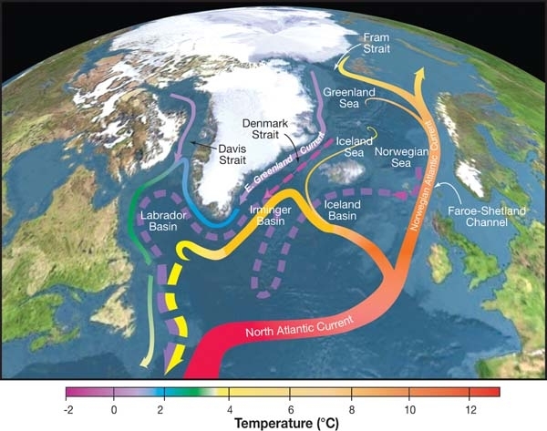
| Description | English: Topographic map of the Nordic Seas and subpolar basins with schematic circulation of surface currents (solid curves) and deep currents (dashed curves) that form a portion of the Atlantic meridional overturning circulation. Colors of curves indicate approximate temperatures. |
| Date | |
| Source | http://editors.eol.org/eoearth/wiki/File:OCP07_Fig-6.jpg |
| Author | R. Curry, Woods Hole Oceanographic Institution/Science/USGCRP. |
Licensing
This file is licensed under the Creative Commons Attribution 3.0 Unported license.
- You are free:
- to share – to copy, distribute and transmit the work
- to remix – to adapt the work
- Under the following conditions:
- attribution – You must give appropriate credit, provide a link to the license, and indicate if changes were made. You may do so in any reasonable manner, but not in any way that suggests the licensor endorses you or your use.
File history
Click on a date/time to view the file as it appeared at that time.
| Date/Time | Thumbnail | Dimensions | User | Comment | |
|---|---|---|---|---|---|
| current | 06:56, 24 July 2017 | | 600 × 473 (168 KB) | My name is not dave | User created page with UploadWizard |
File usage
The following pages on the English Wikipedia use this file (pages on other projects are not listed):
Global file usage
The following other wikis use this file:
- Usage on ca.wikipedia.org
- Usage on cs.wikipedia.org
- Usage on de.wiktionary.org
- Usage on es.wikipedia.org
- Usage on fr.wikipedia.org
- Usage on hr.wikipedia.org
- Usage on it.wikipedia.org
- Usage on pt.wikipedia.org
- Usage on zh.wikipedia.org