
 French
 Deutsch
File:Persian Empire Abraham Ortelius.jpg

Size of this preview: 461 × 599 pixels. Other resolutions: 184 × 240 pixels | 610 × 793 pixels.
Original file (610 × 793 pixels, file size: 340 KB, MIME type: image/jpeg)
| This is a file from the Wikimedia Commons. Information from its description page there is shown below. Commons is a freely licensed media file repository. You can help. |
Summary
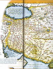
| Description | English: The Kingdom of Persian, this map was created by Dutch cartographer Abraham Ortelius, the first modern Atlas, and was printed from 1570 to 1624 فارسی: پادشاهی ایران، این نقشه توسط کارتوگرافر بلژیکی «آبراهام ارتلیوس» ساخته شده که در نخستین اطلس نوین در میان سالهای ۱۵۷۰ تا ۱۶۲۴ چاپ شدهاست | |||||||||||||||||||||||
| Date | to 1624. | |||||||||||||||||||||||
| Source | Fred Ramen, A historical atlas of Iran, published in 2003 | |||||||||||||||||||||||
| Author |
| |||||||||||||||||||||||

Licensing
| This is a faithful photographic reproduction of a two-dimensional, public domain work of art. The work of art itself is in the public domain for the following reason:
The official position taken by the Wikimedia Foundation is that "faithful reproductions of two-dimensional public domain works of art are public domain". This photographic reproduction is therefore also considered to be in the public domain in the United States. In other jurisdictions, re-use of this content may be restricted; see Reuse of PD-Art photographs for details. | ||||
File history
Click on a date/time to view the file as it appeared at that time.
| Date/Time | Thumbnail | Dimensions | User | Comment | |
|---|---|---|---|---|---|
| current | 12:20, 8 October 2008 | | 610 × 793 (340 KB) | Wayiran | {{Information |Description={{en|1=The Kingdom of Persian, this map was created by Dutch cartographer Abraham Ortelius, the first modern Atlas, and was printed from 1570 to 1624}} {{fa|1=پادشاهی ایران، این نقشه توسط کارتوگرا |
File usage
The following pages on the English Wikipedia use this file (pages on other projects are not listed):
Global file usage
The following other wikis use this file:
- Usage on azb.wikipedia.org
- Usage on cs.wikipedia.org
- Usage on eo.wikipedia.org
- Usage on fa.wikipedia.org
- Usage on he.wikipedia.org
- Usage on hi.wikipedia.org
- Usage on ja.wikipedia.org
- Usage on kn.wikipedia.org
- Usage on ko.wikipedia.org
- Usage on la.wikipedia.org
- Usage on pnb.wikipedia.org
- Usage on pt.wikipedia.org
- Usage on ro.wikipedia.org
- Usage on ru.wikipedia.org
- Usage on sl.wikipedia.org
- Usage on tr.wikipedia.org
- Usage on ur.wikipedia.org