
 French
 Deutsch
File:Purna river near Ghodasgaon.jpg

Size of this preview: 800 × 486 pixels. Other resolutions: 320 × 194 pixels | 640 × 389 pixels | 1,040 × 632 pixels.
Original file (1,040 × 632 pixels, file size: 296 KB, MIME type: image/jpeg)
| This is a file from the Wikimedia Commons. Information from its description page there is shown below. Commons is a freely licensed media file repository. You can help. |
Summary
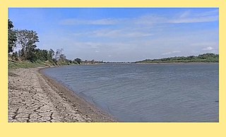
| Description | English: This file have photograph of Purna river, which is taken near Ghodasgaon in Muktainagar taluka of Jalgaon district in Maharashtra, India. Purna river flows through Muktainagar taluka it empties into Tapi river near Changdeva village. |
| Date | |
| Source | Own work |
| Author | Huge Earth |
| Camera location | | View this and other nearby images on: OpenStreetMap |
|---|
This image is taken in summer.
Licensing
I, the copyright holder of this work, hereby publish it under the following license:
This file is licensed under the Creative Commons Attribution-Share Alike 4.0 International license.
- You are free:
- to share – to copy, distribute and transmit the work
- to remix – to adapt the work
- Under the following conditions:
- attribution – You must give appropriate credit, provide a link to the license, and indicate if changes were made. You may do so in any reasonable manner, but not in any way that suggests the licensor endorses you or your use.
- share alike – If you remix, transform, or build upon the material, you must distribute your contributions under the same or compatible license as the original.
File history
Click on a date/time to view the file as it appeared at that time.
| Date/Time | Thumbnail | Dimensions | User | Comment | |
|---|---|---|---|---|---|
| current | 12:43, 16 May 2021 | | 1,040 × 632 (296 KB) | Huge Earth | Uploaded own work with UploadWizard |
File usage
The following pages on the English Wikipedia use this file (pages on other projects are not listed):
Global file usage
The following other wikis use this file:
- Usage on mr.wikipedia.org