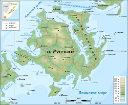
File:Russky island topographic map-en.svg

Size of this PNG preview of this SVG file: 733 × 600 pixels. Other resolutions: 293 × 240 pixels | 587 × 480 pixels | 939 × 768 pixels | 1,252 × 1,024 pixels | 2,503 × 2,048 pixels | 1,100 × 900 pixels.
Original file (SVG file, nominally 1,100 × 900 pixels, file size: 296 KB)
File history
Click on a date/time to view the file as it appeared at that time.
| Date/Time | Thumbnail | Dimensions | User | Comment | |
|---|---|---|---|---|---|
| current | 09:41, 20 February 2009 |  | 1,100 × 900 (296 KB) | Chakat Rimm | {{Information |Description={{en|1=Topographic map of Russky Island, Primorsky kray, Russia.}} {{ru|1=Топографическая карта острова Русский Приморского края на английском языке.}} |Source=Ow |
File usage
The following 2 pages use this file:
Global file usage
The following other wikis use this file:
- Usage on az.wikipedia.org
- Usage on ceb.wikipedia.org
- Usage on de.wikipedia.org
- Usage on de.wikivoyage.org
- Usage on fi.wikipedia.org
- Usage on fr.wikipedia.org
- Usage on fr.wikinews.org
- Usage on it.wikipedia.org
- Usage on ja.wikipedia.org
- Usage on pl.wikipedia.org
- Usage on pt.wikipedia.org
- Usage on vi.wikipedia.org
- Usage on zh.wikipedia.org


 French
 Deutsch
