
 French
 Deutsch
File:Spring and Mary streets, Newport, RI edit.jpg

Size of this preview: 799 × 599 pixels. Other resolutions: 320 × 240 pixels | 640 × 480 pixels | 1,024 × 768 pixels | 1,280 × 960 pixels | 2,130 × 1,598 pixels.
Original file (2,130 × 1,598 pixels, file size: 2.62 MB, MIME type: image/jpeg)
| This is a file from the Wikimedia Commons. Information from its description page there is shown below. Commons is a freely licensed media file repository. You can help. |
| This is an image of a place or building that is listed on the National Register of Historic Places in the United States of America. Its reference number is 68000001. |
| This is a retouched picture, which means that it has been digitally altered from its original version. Modifications: Edit to correct perspective distortion and replace blown sky by Mfield.
|
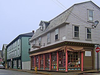
| Description | Historic, Colonial-era buildings along Spring Street just north of Mary Street in the Newport, RI, USA, historic district | ||||||||
| Date | |||||||||
| Source | Own work | ||||||||
| Author | Daniel Case | ||||||||
| Permission (Reusing this file) | Daniel Case at the English-language Wikipedia, the copyright holder of this work, hereby publishes it under the following license:
| ||||||||
| Other versions |  |

| Object location | | View this and other nearby images on: OpenStreetMap |
|---|
File history
Click on a date/time to view the file as it appeared at that time.
| Date/Time | Thumbnail | Dimensions | User | Comment | |
|---|---|---|---|---|---|
| current | 07:40, 1 May 2008 | | 2,130 × 1,598 (2.62 MB) | Mfield | {{RetouchedPicture|Edit to correct perspective distortion and replace blown sky by Mfield}} {{Information |Description=Historic, Colonial-era buildings along Spring Street just north of Mary Street in the [[w:Newport |
File usage
The following pages on the English Wikipedia use this file (pages on other projects are not listed):
Global file usage
The following other wikis use this file:
- Usage on de.wikipedia.org
- Usage on fr.wikipedia.org
- Usage on ja.wikipedia.org
- Usage on www.wikidata.org